 view gallery view gallery N5.8 km N5.8 km
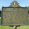
|   Naming of the Cumberland River Historical Marker - Pineville, KY Naming of the Cumberland River Historical Marker - Pineville, KY
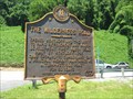
in Kentucky Historical Markers This historical marker is located along US-25E about a mile south of Pineville, KY. It describes how the Cumberland River was named. posted by:  onfire4jesus onfire4jesus location: Kentucky date approved: 05/30/2008 last visited: 09/22/2017 |
 view gallery view galleryN5.8 km |  Wilderness Road Heritage Highway - Naming of the Cumberland River Historical Marker - Pineville, KY Wilderness Road Heritage Highway - Naming of the Cumberland River Historical Marker - Pineville, KY
in National Scenic Byways The Wilderness Road Heritage Highway was the route that many late-18th century settlers traveled into Kentucky, one of the most famous being Daniel Boone. Much of the route follows the Cumberland River. This marker tells how it was named. posted by: onfire4jesus location: Kentucky date approved: 05/29/2008 last visited: 05/24/2008 |
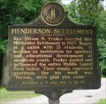 view gallery view galleryN5.8 km | Henderson Settlement in Kentucky Historical Markers Marker noting the formation of a Methodist settlement in 1925 posted by:  PersonsMD PersonsMD location: Kentucky date approved: 08/16/2009 last visited: 07/01/2010 |
 view gallery view galleryN5.8 km |  Wilderness Road Cemetery ~ Pineville, Kentucky. Wilderness Road Cemetery ~ Pineville, Kentucky.
in Worldwide Cemeteries This cemetery was established by pioneers following the Daniel Boone Wilderness trail in the late 1700's. posted by: Manville Possum location: Kentucky date approved: 04/24/2018 last visited: 04/25/2018 |
 view gallery view galleryN5.8 km | Wilderness Road Cemetery ~ Pineville, Kentucky in Kentucky Historical Markers This marker is for a cemetery was established by pioneers traveling along Boone's Wilderness Road during the late 1700's and early 1800's. posted by: Manville Possum location: Kentucky date approved: 11/25/2020 last visited: 11/25/2020 |
 view gallery view gallery SE6.4 km SE6.4 km
|  Q 274 (GA2756) - Near Middlesboro, Bell County KY Q 274 (GA2756) - Near Middlesboro, Bell County KY
in U.S. Benchmarks A USC&G benchmark disk mounted vertically in a rock outcrop on State Hwy 988 (Sugar Run Overlook Rd) NE of Middlesboro KY. posted by: Team Geologynut location: Kentucky date approved: 05/05/2023 last visited: never |
 view gallery view gallerySE6.4 km | R 274 RESET (GA3232) - Near Middlesboro, Bell County KY in U.S. Benchmarks An NGS vertical control disk on a bridge on State Hwy 988 NE of Middlesboro, KY. Safe parking around 150ft west of the bridge. posted by: Team Geologynut location: Kentucky date approved: 05/05/2023 last visited: never |
 view gallery view galleryN6.6 km | Invasion and Retreat in Kentucky Historical Markers Kentucky Historical Marker number 683 placed by the Kentucky Historical Society and Kentucky Department of Highways in 2008. posted by: Manville Possum location: Kentucky date approved: 04/16/2018 last visited: 04/17/2018 |
 view gallery view gallerySE6.8 km | S 274 (GA2758) - Near Middlesboro, Bell County KY in U.S. Benchmarks A USC&G benchmark disk mounted vertically in a rock outcrop on KY-217 NE of Middlesboro KY. Narrow parking across road from it. posted by: Team Geologynut location: Kentucky date approved: 05/05/2023 last visited: never |
 view gallery view gallery S6.9 km S6.9 km
|  Subway - 12th Street (US 25E) - Middlesboro, KY Subway - 12th Street (US 25E) - Middlesboro, KY
in Subway Restaurants Subway located in a small strip mall on 12th Street (US 25E) in Middlesboro, KY. Covenant to the Cumberland Gap national park posted by: Lat34North location: Kentucky date approved: 10/22/2011 last visited: 10/22/2011 |
 view gallery view galleryN6.9 km | Chained Rock ~ Pineville, Kentucky in Kentucky Historical Markers Chained Rock is a boulder formation on Pine Mountain held in place by a chain. posted by: Manville Possum location: Kentucky date approved: 11/25/2020 last visited: 11/25/2020 |
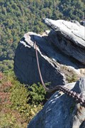 view gallery view galleryN6.9 km |  Chained Rock - Pineville, KY Chained Rock - Pineville, KY
in Urban Legends and Superstitions A 101 ft. long chain, traditionally said to protect the town of Pineville Ky by holding a large rock in place on a bluff above the town. posted by: walkerm location: Kentucky date approved: 05/07/2016 last visited: 04/13/2018 |
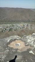 view gallery view galleryN7.2 km | GA3577 LOOKOUT ROCK REFERENCE MARK NO.2 Bell Co, Kentucky in U.S. Benchmarks REFERENCE MARK NO.2 IS SET IN LARGE BOULDER OVERLOOKING PINEVILLE.
IT IS 1.35 FEET NORTH OF OCCIDENT (USGS). THE DISK IS SET FLUSH AND IS STAMPED LOOKOUT ROCK NO 2 1950. posted by: NCDaywalker location: Kentucky date approved: 06/14/2018 last visited: 06/02/2018 |
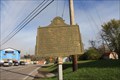
 view gallery view galleryN7.2 km | The Wilderness Road - Pineville, KY in Kentucky Historical Markers The Wilderness Road was the first wagon highway built by Kentucky posted by: vhasler location: Kentucky date approved: 07/03/2010 last visited: never |
 view gallery view galleryS7.2 km |  Cumberland Gap Trail Marker Tree South Cumberland Gap Trail Marker Tree South
in Native American Trail Trees located of Kentucky State Hwy 988 South East of Wilderness Road. This tree is visable from the State Hwy and is pointing South towards the Cumberland Gap. posted by: pine45 location: Kentucky date approved: 08/30/2012 last visited: never |
 view gallery view galleryS7.7 km | Watts Furnaces/Iron Made in Kentucky in Kentucky Historical Markers On US 25E at KY 441 in Middlesboro. posted by: Markerman62 location: Kentucky date approved: 04/08/2015 last visited: 04/08/2015 |
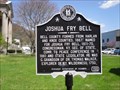 view gallery view galleryN7.7 km | Joshua Fry Bell - Pineville, Kentucky 198 in Kentucky Historical Markers Marker honoring Political leader, Joshua Fry Bell located on the Courthouse lawn in the city of Pineville, Kentucky posted by: PersonsMD location: Kentucky date approved: 04/14/2009 last visited: 05/17/2016 |
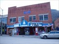 view gallery view galleryN7.7 km |  Bell Theater Bell Theater
in Vintage Movie Theaters Bell Theater, Pineville, Kentucky posted by: Wallyum location: Kentucky date approved: 03/28/2021 last visited: never |
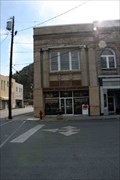 view gallery view galleryN7.7 km |  Bell National Bank - Pineville, KY Bell National Bank - Pineville, KY
in Converted Bank Buildings Bell National Bank located on Kentucky Ave, across the street from the old Bell County Courthouse. Now a law office. posted by: Lat34North location: Kentucky date approved: 11/01/2011 last visited: 10/23/2011 |
 view gallery view galleryN7.7 km | Subway - Kentucky Ave - Pineville, KY in Subway Restaurants Subway located on Kentucky Ave in downtown Pineville, KY. posted by: Lat34North location: Kentucky date approved: 11/01/2011 last visited: 10/23/2011 |
 view gallery view galleryN7.9 km |  Pineville Courthouse Square Historic District - Pineville, KY Pineville Courthouse Square Historic District - Pineville, KY
in U.S. National Register of Historic Places The Pineville Courthouse Square district was added to the National Register of Historic Places in 1990. The old courthouse stands in the Square formed by Kentucky Ave., Pine St., Virginia Ave., and Walnut St. posted by: Lat34North location: Kentucky date approved: 11/01/2011 last visited: 10/23/2011 |
 view gallery view galleryS7.9 km | Oldest House - Middlesboro, KY in Kentucky Historical Markers Located at 1003 North 19th Street, Middlesborough, KY. posted by: Lat34North location: Kentucky date approved: 10/23/2011 last visited: 10/21/2011 |
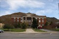
 view gallery view galleryN7.9 km |  Bell County Courthouse - Pineville, KY Bell County Courthouse - Pineville, KY
in Courthouses Bell County Courthouse in Pineville, KY posted by: Team Geologynut location: Kentucky date approved: 05/09/2023 last visited: never |
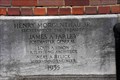 view gallery view galleryN7.9 km |  1935 - Post Office - Pineville, KY 1935 - Post Office - Pineville, KY
in Dated Buildings and Cornerstones This dated stone is located on the SW corner of the Pineville, KY, Post Office on South Walnut Street. posted by: Lat34North location: Kentucky date approved: 11/01/2011 last visited: 10/23/2011 |
 view gallery view galleryN7.9 km |  Bell Masonic Lodge No. 691 F&AM, Pineville, Kentucky Bell Masonic Lodge No. 691 F&AM, Pineville, Kentucky
in Masonic Temples Masonic lodge located in Pineville, Kentucky. posted by: PersonsMD location: Kentucky date approved: 04/11/2009 last visited: 04/08/2009 |
|