 view gallery view gallery NW19.2 km NW19.2 km
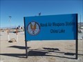
|   China Lake Naval Air Station Ridgecrest CA China Lake Naval Air Station Ridgecrest CA
in Military Installations An active base since WWII. One of the largest fields at 200,000 acres. Kern County. Mojave Desert. posted by:  sbcamper sbcamper location: California date approved: 08/13/2022 last visited: never |
 view gallery view gallery SW20.8 km SW20.8 km
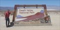
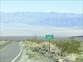
|  Death Valley National Park - California, US Death Valley National Park - California, US
in Civilian Conservation Corps Death Valley was established as a national monument in Feb 1933. CCC helped improve the visitor experience by building campgrounds, restrooms and picnic facilities. The park could not have accommodated visitors in its first years without the CCC. posted by: T-Team! location: California date approved: 04/06/2023 last visited: never |
 view gallery view gallery S24.8 km S24.8 km
|  Darwin Falls Darwin Falls
in Waterfalls While on expedition with OffroadPassport.com we found out about this waterfall near Panamint Springs Resort in Panamint Valley, CA posted by: dzjeepchic location: California date approved: 09/05/2009 last visited: 10/03/2017 |
 view gallery view gallery SE26.6 km SE26.6 km
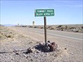
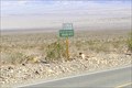
|  Townes Pass, 4956 Feet Townes Pass, 4956 Feet
in Elevation Signs Sign for Townes Pass on Highway 190. posted by:  Six Little Spookies Six Little Spookies location: California date approved: 03/26/2008 last visited: 09/20/2009 |
 view gallery view gallery E26.7 km E26.7 km
| 3000 Feet, Death Valley in Elevation Signs 3000 Feet elevation sign on Highway 190 in Death Valley. posted by: Six Little Spookies location: California date approved: 03/26/2008 last visited: 04/22/2022 |
 view gallery view galleryE28.3 km | 1000 Feet, Death Valley in Elevation Signs 1000 Foot elevation sign on Highway 190 inside Death Valley. posted by: Six Little Spookies location: California date approved: 03/26/2008 last visited: 04/22/2022 |
 view gallery view gallerySE28.8 km | 4000 Feet, Highway 190 in Elevation Signs 4000 feet elevation sign on Highway 190 leading into Death Valley. posted by: Six Little Spookies location: California date approved: 03/26/2008 last visited: 03/23/2015 |
 view gallery view gallery W30.7 km W30.7 km
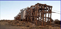
|  Inyo Mountain Salt Tram Inyo Mountain Salt Tram
in Mines Historic Salt Tram posted by: JustRuns location: California date approved: 02/27/2010 last visited: 04/21/2010 |
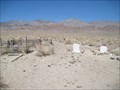 view gallery view galleryW31.5 km |  Keeler Cemetery - Keeler, CA Keeler Cemetery - Keeler, CA
in Abandoned Cemeteries This cemetery is just outside the town of Keeler on the north side of Owens Lake, N of State Highway 136, SE of the town of Keeler, between two historic marker signs. Take care when pulling off the highway, the ground may be soft and/or rocky. posted by: dspeer location: California date approved: 08/22/2011 last visited: 08/03/2012 |
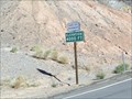
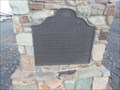 view gallery view galleryE34 km |  Eichbaum Toll Road - Stovepipe Wells, CA Eichbaum Toll Road - Stovepipe Wells, CA
in California Historical Markers Historic Marker recounting the establishment of the first tourist toll road into Death Valley. posted by: jiggs11 location: California date approved: 05/09/2017 last visited: never |
 view gallery view galleryE34.1 km |  Stovepipe Wells - Death Valley National Park, CA Stovepipe Wells - Death Valley National Park, CA
in Dog Friendly Hotels Stovepipe Wells has the only dog-friendly motel in Death Valley National Park. Dawg has stayed here several times. Dogs...beware of the resident coyotes! Once they stalked Dawg while she was peeing near the bushes outside of her room! posted by: Team Min Dawg location: California date approved: 04/26/2010 last visited: 04/02/2011 |
 view gallery view galleryE34.1 km |  Stovepipe Wells, Death Valley, CA Stovepipe Wells, Death Valley, CA
in Payphones The payphone in the motel at Stovepipe Wells Village. We love that Death Valley and San Diego have the same area code! You'll need to use this one, too, as cell phone service is pretty much zero. posted by: Team Taskmaster location: California date approved: 04/05/2006 last visited: 12/30/2011 |
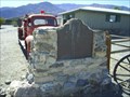 view gallery view galleryE34.1 km | Burned Wagons Point - Stovepipe Wells, CA in California Historical Markers Historical marker number 441 located in Stovepipe Wells, CA, inside Death Valley. posted by: Six Little Spookies location: California date approved: 04/03/2008 last visited: 04/07/2022 |
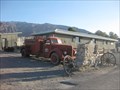
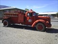 view gallery view galleryE34.1 km |  Fire Truck, Stovepipe Wells, CA Fire Truck, Stovepipe Wells, CA
in Fire Fighting Vehicles Old fire truck in Stovepipe Wells, CA, in Death Valley. posted by: Six Little Spookies location: California date approved: 03/29/2008 last visited: 04/07/2022 |
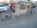 view gallery view galleryE34.1 km |  Wagon Wheels - Burned Wagons Point Historic Marker - Stovepipe Wells, CA Wagon Wheels - Burned Wagons Point Historic Marker - Stovepipe Wells, CA
in Wagon Wheels A pair of old wagon wheels complementing the "Burned Wagons Point" historic Marker in Stovepipe Wells. posted by: jiggs11 location: California date approved: 05/09/2017 last visited: 04/07/2022 |
 view gallery view galleryE34.1 km |  Stovepipe Wells, California Stovepipe Wells, California
in Wikipedia Entries Stovepipe Wells is a small way-station in the northern part of Death Valley, in unincorporated Inyo County, California. posted by: ChapterhouseInc location: California date approved: 02/24/2011 last visited: 04/07/2022 |
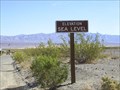 view gallery view galleryE34.1 km | Death Valley Sea Level #1 in Elevation Signs Sea Level sign at Stovepipe Wells in Death Valley. posted by: Six Little Spookies location: California date approved: 03/26/2008 last visited: 05/28/2012 |
 view gallery view galleryE34.3 km | Sea Level - Stovepipe Wells Ranger Station - Death Valley National Park, CA in Elevation Signs The sign at the Stovepipe Wells Ranger Station gives the elevation as "Sea Level" - in Death Valley National Park, California. posted by: The Snowdog location: California date approved: 01/04/2023 last visited: 04/07/2022 |
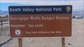 view gallery view galleryE34.3 km |  Stovepipe Wells Ranger Station - Death Valley National Park, CA Stovepipe Wells Ranger Station - Death Valley National Park, CA
in Ranger Stations The Stovepipe Wells Ranger Station offers a place to pay your park entrance fee, stamp your National Park Passport, and pick up a map - in Death Valley National Park, California. posted by: The Snowdog location: California date approved: 01/06/2023 last visited: never |
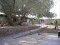
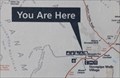 view gallery view galleryE34.3 km |  You Are Here - Stovepipe Wells, CA You Are Here - Stovepipe Wells, CA
in 'You Are Here' Maps This "You Are Here" map indicates that your current location is Stovepipe Wells - in Death Valley National Park, California. posted by: The Snowdog location: California date approved: 01/04/2023 last visited: never |
 view gallery view galleryE34.3 km |  Death Valley National Park - Stovepipe Wells NPS Stamp Death Valley National Park - Stovepipe Wells NPS Stamp
in NPS Passport Cancellation Stations The Stovepipe Wells NPS Passport Cancellation Station is inside the Stovepipe Wells Ranger Station near the west entrance to Death Valley National Park on Highway 190. posted by: shell1fish location: California date approved: 03/26/2013 last visited: 01/04/2023 |
 view gallery view galleryE36.7 km |  Star Wars Filming of Tatooine Episode 4 - Death Valley National Park, CA Star Wars Filming of Tatooine Episode 4 - Death Valley National Park, CA
in All Things Star Wars In the Mesquite Sand Dunes of Death Valley National Park, Star Wars Episode 4 was filmed here! posted by: bluesnote location: California date approved: 02/23/2012 last visited: 04/07/2022 |
 view gallery view galleryE36.7 km |  Star Wars Filming of Tatooine Episode 4 - Death Valley National Park, CA Star Wars Filming of Tatooine Episode 4 - Death Valley National Park, CA
in Movie Locations In the Mesquite Sand Dunes of Death Valley National Park, Star Wars Episode 4 was filmed here! posted by: bluesnote location: California date approved: 03/01/2012 last visited: 04/07/2022 |
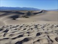
 view gallery view galleryE36.7 km |  Mesquite Flat Sand Dunes - Death Valley National Park, CA Mesquite Flat Sand Dunes - Death Valley National Park, CA
in Metal Detecting The Mesquite flat San Dunes of Death Valley National Park offer over 14 square miles of sand, and this means, you can go treasure hunting! posted by: bluesnote location: California date approved: 02/26/2012 last visited: 01/03/2024 |
 view gallery view galleryE36.7 km |  Mesquite Flat Sand Dunes - Death Valley Scenic Byway - Death Valley National Park, CA Mesquite Flat Sand Dunes - Death Valley Scenic Byway - Death Valley National Park, CA
in National Scenic Byways In the Mesquite Sand Dunes of Death Valley National Park, Star Wars Episode 5 was filmed here! posted by: bluesnote location: California date approved: 03/29/2016 last visited: 01/04/2023 |
|