 view gallery view gallery SE0.5 km SE0.5 km
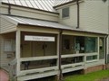
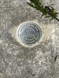
|   U 197 (GB0948) - Oneida, Scott County, TN U 197 (GB0948) - Oneida, Scott County, TN
in U.S. Benchmarks An easy to find USG&C Benchmark Disk mounted vertically in a building in Oneida, TN. Plenty of parking at building. posted by:  Team Geologynut Team Geologynut location: Tennessee date approved: 09/07/2023 last visited: never |
 view gallery view gallery S10.3 km S10.3 km
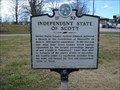
|  Independent State of Scott - 1F32 - Huntsville, TN Independent State of Scott - 1F32 - Huntsville, TN
in Tennessee Historical Markers This historical marker is located along Highway 63 in Huntsville, Tennessee. posted by: Marine Biologist location: Tennessee date approved: 12/28/2008 last visited: 12/28/2008 |
 view gallery view gallery NE12.4 km NE12.4 km
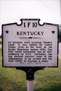
| Kentucky/Tennessee-1F10-Scott County in Tennessee Historical Markers At the state line in Scott County on US 27 with ample room to pull off. posted by: Markerman62 location: Tennessee date approved: 04/08/2015 last visited: 04/08/2015 |
 view gallery view gallery W12.6 km W12.6 km
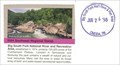
|  Big South Fork National River and Recreation Area - Oneida TN Big South Fork National River and Recreation Area - Oneida TN
in Wikipedia Entries Encompassing 125,000 acres of the Cumberland Plateau, Big South Fork National River and Recreation Area protects the free-flowing Big South Fork of the Cumberland River and its tributaries. posted by:  Don.Morfe Don.Morfe location: Tennessee date approved: 09/09/2023 last visited: 09/09/2023 |
 view gallery view galleryW12.6 km |  Big South Fork National River and Recreation Area - Oneida, TN Big South Fork National River and Recreation Area - Oneida, TN
in NPS Passport Cancellation Stations A NPS Cancellation stamp may be obtained inside the Visitor Center at the Big South Fork National River and Recreation Area located at 4564 Leatherwood Road, Oneida, TN 37841 posted by: Don.Morfe location: Tennessee date approved: 10/08/2023 last visited: 10/08/2023 |
 view gallery view galleryW12.6 km | ") Big South Fork National River and Recreation Area - Oneida, TN Big South Fork National River and Recreation Area - Oneida, TN
in National Parks (U.S.) Encompassing 125,000 acres of the Cumberland Plateau, Big South Fork National River and Recreation Area protects the free-flowing Big South Fork of the Cumberland River and its tributaries. posted by: Don.Morfe location: Tennessee date approved: 12/12/2019 last visited: 10/28/2021 |
 view gallery view galleryW12.6 km |  Big South Fork National River and Recreation Area - Oneida TN Big South Fork National River and Recreation Area - Oneida TN
in National Parks of the World Encompassing 125,000 acres of the Cumberland Plateau, Big South Fork National River and Recreation Area protects the free-flowing Big South Fork of the Cumberland River and its tributaries. posted by: Don.Morfe location: Tennessee date approved: 09/09/2023 last visited: 09/09/2023 |
 view gallery view galleryW12.6 km |  Big South Fork National River and Recreation Area - Oneida, TN Big South Fork National River and Recreation Area - Oneida, TN
in Official Local Tourism Attractions Encompassing 125,000 acres of the Cumberland Plateau, Big South Fork National River and Recreation Area protects the free-flowing Big South Fork of the Cumberland River and its tributaries. posted by: Don.Morfe location: Tennessee date approved: 09/09/2023 last visited: 09/09/2023 |
 view gallery view galleryW12.6 km |  Ranger Station at Big South Fork National River and Recreation Area - Oneida, TN Ranger Station at Big South Fork National River and Recreation Area - Oneida, TN
in Ranger Stations A Ranger Station is inside the visitor center at the Big South Fork National River and Recreation Area located at 4564 Leatherwood Road, Oneida, TN 37841 posted by: Don.Morfe location: Tennessee date approved: 09/15/2023 last visited: 09/15/2023 |
 view gallery view galleryW12.6 km |  Big South Fork National River and Recreation Area - Oneida, TN Big South Fork National River and Recreation Area - Oneida, TN
in Satellite Imagery Oddities Encompassing 125,000 acres of the Cumberland Plateau, Big South Fork National River and Recreation Area protects the free-flowing Big South Fork of the Cumberland River and its tributaries. posted by: Don.Morfe location: Tennessee date approved: 09/09/2023 last visited: 09/09/2023 |
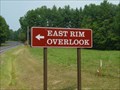 view gallery view galleryW13.7 km |  Big South Fork East Rim Overlook Big South Fork East Rim Overlook
in Scenic Overlooks An overlook on the east side of the Big South Fork National River & Recreation Area. posted by: ggmorton location: Tennessee date approved: 09/12/2007 last visited: 10/18/2012 |
 view gallery view galleryW18 km | Big South Fork National River and Recreation Area Bandy Creek Visitor Center - Oneida, TN in NPS Passport Cancellation Stations A NPS station at this visitor center in north central TN. posted by: ggmorton location: Tennessee date approved: 09/14/2007 last visited: 10/19/2012 |
 view gallery view gallery NW18.8 km NW18.8 km
|  Object Lesson Trail - Cumberland Gap NP Object Lesson Trail - Cumberland Gap NP
in Hiking and walking trailheads The Object Lesson Trail is a short (0.6 mils) trail that provides access to the “saddle” of the Cumberland Gap from the “Thomas Walker” parking lot on Pinnacle Road. Several trails intersect at the saddle. posted by: Lat34North location: Kentucky date approved: 11/16/2011 last visited: 10/22/2011 |
 view gallery view gallery N19.2 km N19.2 km
|  Edward "Eddie" Ward #2300 - Pine Knot, KY Edward "Eddie" Ward #2300 - Pine Knot, KY
in Kentucky Historical Markers Edward "Eddie" Ward #2300 is located on the southbound side of Hwy 27 in Pine Knot, KY. The text on this marker is different on each side. posted by: Team Geologynut location: Kentucky date approved: 04/18/2023 last visited: never |
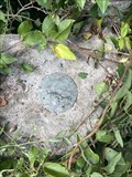 view gallery view galleryNE21.2 km | K 195 (GB0183) - McCreary County,KY in U.S. Benchmarks An easy to find USG&C Benchmark Disk in a culvert headwall. The road is now a dead end and doesn't connect to highway so you can park right next to it...literally! posted by: Team Geologynut location: Kentucky date approved: 09/07/2023 last visited: never |
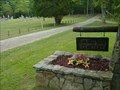 view gallery view gallery SW22 km SW22 km
|  Laurel Dale Cemetery - Rugby, TN Laurel Dale Cemetery - Rugby, TN
in Worldwide Cemeteries Rugby's Laurel Dale Cemetery is just off the main road in Rugby, TN. posted by: ggmorton location: Tennessee date approved: 06/16/2021 last visited: 09/03/2007 |
 view gallery view galleryN22.2 km | STEARNS MUNICIPAL TANK (GB2515) - Sterns, KY in U.S. Benchmarks An elevated water tank benchmark in Sterns, KY. posted by: Team Geologynut location: Kentucky date approved: 04/20/2023 last visited: never |
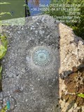
 view gallery view gallerySW22.7 km | T 096 (GB0906) - Scott County, TN in U.S. Benchmarks An easy to spot but not so easy to get to USC& G Benchmark Disk right off Hwy 27 in Scott County. Plenty of parking next to it but it's a scramble up some loose RR gravel to get to it! posted by: Team Geologynut location: Tennessee date approved: 09/07/2023 last visited: never |
 view gallery view galleryNE22.9 km | D 50 Reset (AD9238) McCreary County, KY in U.S. Benchmarks An easy to find NGS Vertical Control Disk on a bridge abutment on what I think is Old Hwy 92. I parked at a pull off on the east side of the bridge and walked across since there was little if any traffic. posted by: Team Geologynut location: Kentucky date approved: 09/07/2023 last visited: never |
 view gallery view gallerySW22.9 km |  Christ Church Episcopal - Rugby, TN Christ Church Episcopal - Rugby, TN
in Anglican and Episcopal Churches Christ Church Episcopal was built in 1887 in Rugby, TN and been in use since that time. posted by: ggmorton location: Tennessee date approved: 06/14/2021 last visited: 09/03/2007 |
 view gallery view gallerySW22.9 km |  Memorial Window - Christ Church Episcopal, Rugby, TN - USA Memorial Window - Christ Church Episcopal, Rugby, TN - USA
in Stained Glass Windows A memorial stained glass window in the the apse of the Christ Church Episcopal in historic Rugby, TN. posted by: ggmorton location: Tennessee date approved: 06/14/2021 last visited: 09/03/2007 |
 view gallery view gallerySW22.9 km |  Christ Church Episcopal - Rugby Colony Historic District - Rugby, TN Christ Church Episcopal - Rugby Colony Historic District - Rugby, TN
in NRHP Historic Districts - Contributing Buildings Christ Church Episcopal is on the guided tour of Historic Rugby, and is IMHO one of the highlights of the contributing buildings in this historic district. posted by: ggmorton location: Tennessee date approved: 06/14/2021 last visited: 09/03/2007 |
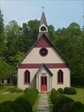 view gallery view gallerySW22.9 km |  Christ Church Episcopal - Rugby, TN Christ Church Episcopal - Rugby, TN
in This Old Church This historic Episcopal church in Rugby, TN is still in use to this day and has been in use since 1887. posted by: ggmorton location: Tennessee date approved: 06/14/2021 last visited: 09/03/2007 |
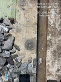
 view gallery view gallerySW23.3 km | S 196 (GB0905) - Scott County, TN in U.S. Benchmarks An easy to find USC&G Benchmark Disk in a bridge abutment just off Hwy 27 in Scott County. PLenty of parking a few feet from the bridge. posted by: Team Geologynut location: Tennessee date approved: 09/07/2023 last visited: never |
 view gallery view galleryN24.5 km |  Lick Creek Falls Lick Creek Falls
in Waterfalls Lick Creek Falls. posted by: mtthomas99 location: Kentucky date approved: 02/20/2012 last visited: 04/22/2013 |
|