 view gallery view gallery NE4.7 km NE4.7 km
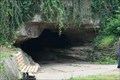
|  ") Bluff Dwellers Cave Bluff Dwellers Cave
in Cave Entrances (Natural) Commercial cave near Noel, MO offering tours. posted by:  wardnkathy wardnkathy location: Missouri date approved: 03/20/2016 last visited: 03/26/2005 |
 view gallery view gallery E6 km E6 km
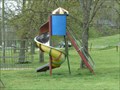
|  City Park Playground - Sulphur Springs, AR City Park Playground - Sulphur Springs, AR
in Public Playgrounds This historic 65-acre park is located on Route 59 in the small town of Sulphur Springs, Benton County, Arkansas. posted by:  silverquill silverquill location: Arkansas date approved: 04/23/2013 last visited: never |
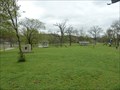
 view gallery view galleryE6 km |  Sulphur Springs Park Reserve - Sulphur Springs. AR Sulphur Springs Park Reserve - Sulphur Springs. AR
in U.S. National Register of Historic Places This historic 65-acre park is located along Butler Creek in the small town of Sulphur Springs, Benton County, Arkansas. posted by: silverquill location: Arkansas date approved: 04/22/2013 last visited: never |
 view gallery view galleryE6 km |  City Park - Sulphur Springs, AR City Park - Sulphur Springs, AR
in Municipal Parks and Plazas This historic 65-acre park is located on Route 59 in the small town of Sulphur Springs, Benton County, Arkansas. posted by: silverquill location: Arkansas date approved: 04/22/2013 last visited: never |
 view gallery view galleryNE7.1 km |  Noel,MO 64854 Noel,MO 64854
in U.S. Post Offices Noel,Nissouri Post Office-64854
318 Main Street posted by: GEO*Trailblazer 1 location: Missouri date approved: 12/04/2006 last visited: 12/03/2013 |
 view gallery view galleryE7.4 km |  M. Waldo Hatler, Sulphur Springs, AR M. Waldo Hatler, Sulphur Springs, AR
in Medal Of Honor Resting Places World War I Medal of Honor Recipient for action near Pouilly, France on November 8, 1918. He is buried in GAR Cemetery, Sulphur Springs, AR. posted by: Don.Morfe location: Arkansas date approved: 09/26/2017 last visited: 12/20/2021 |
 view gallery view galleryNE7.7 km |  HWY. 59 Mural HWY. 59 Mural
in Murals Highway 59 Mural at Conoco,Noel,Missouri posted by: GEO*Trailblazer 1 location: Missouri date approved: 12/04/2006 last visited: 12/04/2006 |
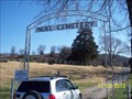 view gallery view galleryNE8.2 km |  Noel Cemetery - Noel, MO Noel Cemetery - Noel, MO
in Worldwide Cemeteries A well-kept cemetery in the town of Noel, Missouri posted by: MountainWoods location: Missouri date approved: 12/04/2013 last visited: 12/03/2013 |
 view gallery view galleryNE8.4 km |  Mill Creek Baptist Church near Noel, MO Mill Creek Baptist Church near Noel, MO
in Country Churches A newly rebuilt Baptist Church in rural McDonald County, Missouri posted by: MountainWoods location: Missouri date approved: 06/05/2014 last visited: 06/04/2014 |
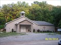 view gallery view galleryNE8.4 km |  Mill Creek Baptist Church - Noel, MO Mill Creek Baptist Church - Noel, MO
in Baptist Churches A newly rebuilt Baptist Church in rural McDonald County, Missouri posted by: MountainWoods location: Missouri date approved: 06/05/2014 last visited: 06/04/2014 |
 view gallery view gallery SE8.4 km SE8.4 km
| Old Spanish Treasure Cave in Cave Entrances (Natural) Cavern open for tours. posted by: wardnkathy location: Arkansas date approved: 06/04/2014 last visited: never |
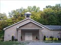 view gallery view galleryNE8.4 km |  Bell Tower at Mill Creek Baptist Church - Noel, MO Bell Tower at Mill Creek Baptist Church - Noel, MO
in Bell Towers A nice bell tower in a newly rebuilt Baptist Church in rural McDonald County, Missouri posted by: MountainWoods location: Missouri date approved: 06/05/2014 last visited: 06/04/2014 |
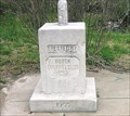
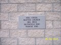 view gallery view galleryNE8.4 km |  2010 - Mill Creek Baptist Church, Noel, MO 2010 - Mill Creek Baptist Church, Noel, MO
in Dated Buildings and Cornerstones A marble block mortared into the front of the newly rebuilt Mill Creek Baptist Church in rural McDonald County, Missouri posted by: MountainWoods location: Missouri date approved: 06/05/2014 last visited: 06/04/2014 |
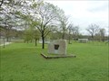
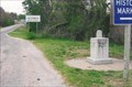
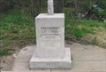 view gallery view gallery W8.5 km W8.5 km
|  Tri-State Boundary Marker - Southwest City, MO Tri-State Boundary Marker - Southwest City, MO
in Lions Clubs International Markers Actually the state is Arkansas - Missouri - & Oklahoma since it sits on the point where all three meet. posted by: YoSam. location: Missouri date approved: 01/15/2015 last visited: 07/17/2020 |
 view gallery view galleryW8.5 km |  Tri-State Identification Marker - 1915 & 1955 - Southwest City, MO & AR & OK Tri-State Identification Marker - 1915 & 1955 - Southwest City, MO & AR & OK
in Dated Architectural Structures Multifarious Original marker, the upgraded, then improved again, without removing the old...point where Arkansas, Missouri and Oklahoma meet. posted by: YoSam. location: Arkansas date approved: 04/14/2019 last visited: 07/17/2020 |
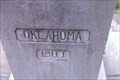 view gallery view galleryW8.5 km |  Tri-State Monument - Delaware County, OK Tri-State Monument - Delaware County, OK
in Oklahoma Historical Markers Where three states meet, southern limits of Southwest City, MO and northwest of Maryville, AR. posted by: YoSam. location: Oklahoma date approved: 11/06/2008 last visited: 07/17/2020 |
 view gallery view galleryW8.5 km |  Border Stone - Tri-State ~ MO, OK, AR Border Stone - Tri-State ~ MO, OK, AR
in Public Land Survey Marks Just S. of Southwest City in Missouri. posted by: YoSam. location: Missouri date approved: 11/11/2009 last visited: 07/17/2020 |
 view gallery view galleryW8.5 km |  Tri-State Marker - Southwest City, MO and AR and OK Tri-State Marker - Southwest City, MO and AR and OK
in Roadside Attractions Original marker, the upgraded, then improved again, without removing the old...point where Arkansas, Missouri and Oklahoma meet. posted by: YoSam. location: Arkansas date approved: 04/14/2019 last visited: 07/17/2020 |
 view gallery view galleryW8.5 km |  OKARMO Corner OKARMO Corner
in Wikipedia Entries Original marker, the upgraded, then improved again, without removing the old...point where Arkansas, Missouri and Oklahoma meet. posted by: YoSam. location: Arkansas date approved: 04/14/2019 last visited: 07/17/2020 |
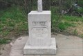
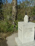
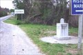 view gallery view galleryW8.5 km |  Tri-State Marker - Southwest City, MO Tri-State Marker - Southwest City, MO
in Missouri Historical Markers The exact spot where three states meet and the western end to the Mason-Dixon Line. posted by: YoSam. location: Missouri date approved: 11/06/2008 last visited: 07/17/2020 |
 view gallery view galleryW8.5 km |  Tr-State Marker - Benton County, AR Tr-State Marker - Benton County, AR
in Arkansas Historical Markers The point where three states meet, NW of Maysville, AR. posted by: YoSam. location: Arkansas date approved: 11/08/2008 last visited: 07/17/2020 |
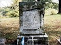
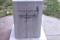
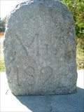 view gallery view galleryW8.5 km |  BONDARY MONUMENT MO ARK OK BONDARY MONUMENT MO ARK OK
in U.S. Historic Survey Stones and Monuments ANOTHER TRI STATE BOUNDARY STONE.
MISSOURI ARKANSAS AND OKLAHOMA.
posted by: GEO*Trailblazer 1 location: Missouri date approved: 10/29/2006 last visited: 07/17/2020 |
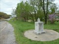 view gallery view galleryW8.5 km |  Oklahoma - Missouri - Arkansas Tripoint Oklahoma - Missouri - Arkansas Tripoint
in Tripoints and Multipoints This marker designates the point where the U.S. states of Oklahoma, Arkansas and Missouri meet. posted by: silverquill location: Oklahoma date approved: 04/22/2013 last visited: 07/17/2020 |
 view gallery view galleryW8.5 km |  BORDER CROSSING MO AR OK BORDER CROSSING MO AR OK
in Border Crossings This Monument marks the SW corner of Missouri The NE corner of Oklahoma and the NW corner of Arkansas posted by: GEO*Trailblazer 1 location: Missouri date approved: 12/02/2007 last visited: 07/17/2020 |
 view gallery view gallery SW9.7 km SW9.7 km
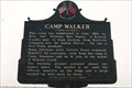
|  Camp Walker - Maysville, AR Camp Walker - Maysville, AR
in American Civil War Monuments and Memorials A huge fort use to stand here. A Confederate camp to recruit Indians and westerners. Raised ground in background is a remnant. posted by: YoSam. location: Arkansas date approved: 01/08/2015 last visited: 07/17/2020 |
|