 view gallery view gallery S24.5 km S24.5 km
|   Pyatt AR 72672 Pyatt AR 72672
in U.S. Post Offices Pyatt is a town in Marion County, Arkansas, United States. The population was 253 at the 2000 census. This rural post office is located at Foster Avenue and Forsyth Street. posted by:  Where's George Where's George location: Arkansas date approved: 12/08/2012 last visited: never |
 view gallery view galleryS24.9 km |  Crooked Creek Bridge - Pyatt AR Crooked Creek Bridge - Pyatt AR
in U.S. National Register of Historic Places The Crooked Creek Bridge, built in 1923, is a one-lane arched bridge that carries a short spur of US Highway 62 from the main highway into the business center of Pyatt. posted by: Where's George location: Arkansas date approved: 01/14/2013 last visited: never |
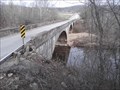 view gallery view galleryS24.9 km |  Crooked Creek Bridge - Pyatt AR Crooked Creek Bridge - Pyatt AR
in Arch Bridges Crooked Creek Bridge is a three-span closed-spandrel arch bridge over Crooked Creek on Spur US 62 at Pyatt. posted by: Where's George location: Arkansas date approved: 12/17/2012 last visited: never |
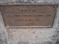 view gallery view galleryS24.9 km |  Crooked Creek Bridge - 1923 - Pyatt AR Crooked Creek Bridge - 1923 - Pyatt AR
in Bridge Date Stones and Plaques Crooked Creek Bridge is a cute little one-lane bridge that connects Highway 62 with the tiny town of Pyatt. posted by: Where's George location: Arkansas date approved: 12/20/2012 last visited: never |
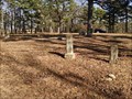 view gallery view gallery W25.6 km W25.6 km
|  Pine Top Cemetery - Pine Top (Mincy), MO USA Pine Top Cemetery - Pine Top (Mincy), MO USA
in Worldwide Cemeteries A small, reactivated cemetery in rural Taney County, Missouri posted by: MountainWoods location: Missouri date approved: 02/05/2016 last visited: 02/05/2016 |
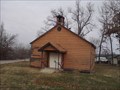
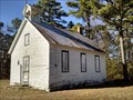 view gallery view galleryW25.9 km |  Pine Top One-Room School - Mincy (Kirbyville), MO USA Pine Top One-Room School - Mincy (Kirbyville), MO USA
in One-Room Schoolhouses An abandoned former one-room school on Pine Top Ridge in the area of the ghost town of Mincy south of Kirbyville in Taney County, Missouri posted by: MountainWoods location: Missouri date approved: 02/05/2016 last visited: 02/05/2016 |
 view gallery view galleryW25.9 km |  Pine Top School - Mincy (Kirbyville), MO USA Pine Top School - Mincy (Kirbyville), MO USA
in Former Schools An abandoned former one-room school on Pine Top Ridge in the area of the ghost town of Mincy south of Kirbyville in Taney County, Missouri posted by: MountainWoods location: Missouri date approved: 02/14/2016 last visited: 01/24/2016 |
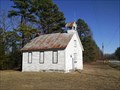
 view gallery view galleryS28.6 km |  Unknown Country Church - Harmon AR Unknown Country Church - Harmon AR
in Country Churches This quaint little country church resides just off US Highway 62 on the way from Harrison to Yellville. It is unnamed, with no signs to identify either its name or affiliation, or even service times, but it is a beautiful example of a country church. posted by: Where's George location: Arkansas date approved: 02/28/2014 last visited: never |
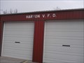 view gallery view galleryS28.8 km |  Harmon V.F.D. Harmon V.F.D.
in Firehouses This 4-bay rural fire station is a few miles east of Harrison on U.S. Hwy 62. It is an all-volunteer department, with 18 volunteers available to respond to emergencies. posted by: Where's George location: Arkansas date approved: 12/19/2012 last visited: never |
  SE29.1 km SE29.1 km
|  Golfer in the Rough Golfer in the Rough
in Figurative Public Sculpture Statue of a golfer about to swing at a ball in the rough. posted by: [DELETED_USER] location: Arkansas date approved: 06/21/2011 last visited: 06/21/2011 |
SE29.1 km |  Forrest and Nina Wood State Park Access Forrest and Nina Wood State Park Access
in Arkansas Historical Markers Site where Nina Wood's ancestors homesteaded and farmed prior to the Bull Shoals Dam construction. posted by: [DELETED_USER] location: Arkansas date approved: 06/22/2011 last visited: 06/08/2017 |
SE29.3 km |  Rivercliff Golf Course Rivercliff Golf Course
in Public and Private Golf Courses Beautiful golf course along side the White River below the Bull Shoals Dam. posted by: [DELETED_USER] location: Arkansas date approved: 06/21/2011 last visited: 06/21/2011 |
SE29.5 km |  Big Spring - Bull Shoals-White River State Park Big Spring - Bull Shoals-White River State Park
in Natural Springs A second magnitude spring flowing into the White River. posted by: [DELETED_USER] location: Arkansas date approved: 06/23/2011 last visited: 11/30/2013 |
SE29.6 km |  Bull Shoals-White River State Park - Arkansas Bull Shoals-White River State Park - Arkansas
in State/Provincial Parks A beautiful park with camping and activities built around a lake and river environment. posted by: [DELETED_USER] location: Arkansas date approved: 07/08/2011 last visited: 08/12/2012 |
 E29.6 km E29.6 km
|  James A Gaston Visitor Center Penny Smasher James A Gaston Visitor Center Penny Smasher
in Penny Smashers A four design penny smasher inside the front door of the visitor center. posted by: [DELETED_USER] location: Arkansas date approved: 06/25/2011 last visited: 06/25/2011 |
E29.6 km |  James A. Gaston Visitor Center Fountain James A. Gaston Visitor Center Fountain
in Fountains A Fountain in front of the beautiful new visitor center for the Bull Shoals-White River State Park. posted by: [DELETED_USER] location: Arkansas date approved: 06/21/2011 last visited: 06/21/2011 |
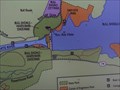 view gallery view galleryE29.6 km |  Bull Shoals-White River State Park - Bull Shoals, AR USA Bull Shoals-White River State Park - Bull Shoals, AR USA
in 'You Are Here' Maps You Are Here map at a Visitors Center at the Bull Shoals Dam in Marion County, Arkansas posted by: MountainWoods location: Arkansas date approved: 06/08/2017 last visited: 06/08/2017 |
E29.6 km |  James A. Gaston Visitor Center James A. Gaston Visitor Center
in Wi-Fi Hotspots The Bull Shoals - White River State Park Visitor Center where there are many fine exhibits and free Wi-Fi access. posted by: [DELETED_USER] location: Arkansas date approved: 06/23/2011 last visited: 06/23/2011 |
E29.8 km |  Bull Shoals Dam - Bull Shoals Arkansas Bull Shoals Dam - Bull Shoals Arkansas
in Water Dams A Dam on the White River at Bull Shoals, Arkansas posted by: [DELETED_USER] location: Arkansas date approved: 06/21/2011 last visited: 06/21/2011 |
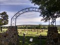 view gallery view gallerySE30.4 km | Mountain View Cemetery - Flippin, AR USA in Worldwide Cemeteries A medium-sized cemetery in rural Marion County, Arkansas posted by: MountainWoods location: Arkansas date approved: 06/08/2017 last visited: 06/08/2017 |
 view gallery view gallerySE30.4 km | Noe (Mtn. View) Cemetery - Flippin, AR USA in Arkansas Historical Markers Marker giving the history of the Noe (now known as Mountain View) Cemetery near Flippin, Arkansas posted by: MountainWoods location: Arkansas date approved: 06/08/2017 last visited: 06/08/2017 |
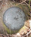 view gallery view galleryE31.4 km |  USGS ERA 2009 USGS ERA 2009
in U.S. Benchmarks USGS Benchmark posted by: jimp180 location: Missouri date approved: 05/27/2008 last visited: never |
 view gallery view gallery SW32 km SW32 km
|  Wal*Mart Supercenter #0002 - Harrison AR Wal*Mart Supercenter #0002 - Harrison AR
in WAL*MART Stores This large Wal*Mart, only the 2nd in the retail giant's chain, seems to be the center of retail commerce in the growing town of Harrison. posted by: Where's George location: Arkansas date approved: 12/08/2012 last visited: never |
 view gallery view gallerySW32 km |  EXTREME SPORTS - Neon EXTREME SPORTS - Neon
in Neon Signs Extreme Sports Neon Harrison Arkansas posted by: GEO*Trailblazer 1 location: Arkansas date approved: 11/18/2007 last visited: 11/18/2007 |
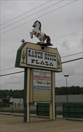 view gallery view gallerySW32 km |  Sassy and Splashy Fiberglass Horse, Harrison AR Sassy and Splashy Fiberglass Horse, Harrison AR
in Fiberglass Horses This spunky horse advertises the Ranch House Business Plaza in Harrison, Arkansas. posted by:  Queens Blessing Queens Blessing location: Arkansas date approved: 06/11/2009 last visited: 06/13/2009 |
|