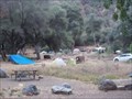
 view gallery view gallery NW18.5 km NW18.5 km
|   Marble fork, Kaweah River - Rio del Morte - Tulare CA Marble fork, Kaweah River - Rio del Morte - Tulare CA
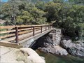
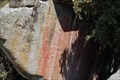
in Hiking Path Footbridges About 35 feet long and 4 feet wide. The bridge crosses about 20 -25 feet above the river. Visitors are warned regarding steep access and the possibility of hypothermia that this river is to be respected. posted by:  sbcamper sbcamper location: California date approved: 05/20/2015 last visited: never |
 view gallery view galleryNW18.8 km |  Buckeye Flat - Sequoia National Park CA Buckeye Flat - Sequoia National Park CA
in Campgrounds 14 day limit. no showers. Shady at 2,820 ft. elev. 860 meters.
29 spaces posted by: sbcamper location: California date approved: 05/21/2015 last visited: never |
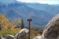 view gallery view galleryNW18.8 km |  Eagle View High Sierra Trail - Sequoia National Park, California Eagle View High Sierra Trail - Sequoia National Park, California
in Scenic Overlooks The High Sierra trail is a beautiful trail that spans the Sierra mountains and runs for many miles. This view is just a mile or so from Crescent meadow in Sequoia National Park. posted by:  teeoff2 teeoff2 location: California date approved: 11/06/2008 last visited: 11/06/2008 |
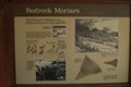 view gallery view galleryNW19.3 km |  Indian Acorn Grinding Mortars- Sequoia National Park, California Indian Acorn Grinding Mortars- Sequoia National Park, California
in New World Ancient Evidence These bedrock grinding mortars are located near Hospital Rock in Sequoia National Park posted by: teeoff2 location: California date approved: 11/04/2008 last visited: 09/23/2016 |
 view gallery view galleryNW19.3 km |  Hospital Rock Pictographs - Sequoia National Park, California Hospital Rock Pictographs - Sequoia National Park, California
in Pictographs Very nice pictographs located at this site in Sequoia National park. posted by: teeoff2 location: California date approved: 10/29/2008 last visited: 09/23/2016 |
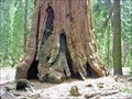
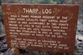 view gallery view galleryNW19.6 km |  Tharp's Log - Sequoia National Park, California Tharp's Log - Sequoia National Park, California
in Treehouses A giant red wood log used as a home for Hale Tharp, the first European settler to homestead in the Sequoia Giant Forest.
This house is on a nice trail that starts at the Cresent Meadow Picnic area in Sequoia National park. posted by: teeoff2 location: California date approved: 10/30/2008 last visited: 10/18/2009 |
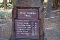 view gallery view galleryNW19.6 km |  High Sierra Trail, Crescent Meadow - Sequoia National Park, Ca. High Sierra Trail, Crescent Meadow - Sequoia National Park, Ca.
in Hiking and walking trailheads A 72.2 mile trail that crosses the Sierra's to Mount Whitney. posted by: teeoff2 location: California date approved: 03/06/2009 last visited: 03/06/2009 |
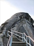 view gallery view galleryNW20.1 km |  Moro Rock Stairway - Sequoia National Park, CA Moro Rock Stairway - Sequoia National Park, CA
in Outdoor Stairways The Moro Rock Stairway is an almost 400 step climb to the summit of Moro Rock in Sequoia National Park. posted by: Merlin-N-Mim location: California date approved: 10/24/2009 last visited: 01/14/2024 |
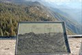 view gallery view galleryNW20.1 km |  Morro Rock - Sequoia National Park, California Morro Rock - Sequoia National Park, California
in Orientation Tables At elevation 6738, these tables show the great features of the surrounding mountains. posted by: teeoff2 location: California date approved: 11/04/2008 last visited: 08/08/2018 |
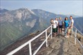 view gallery view galleryNW20.1 km |  Moro Rock, California Moro Rock, California
in Mountain Summits Quick, steep climb up a rock staircase from the parking lot to Moro Rock, Sequoia National Park. posted by: guesszoo location: California date approved: 09/09/2005 last visited: 01/14/2024 |
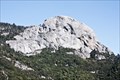 view gallery view galleryNW20.3 km |  Moro Rock - Sequoia National Park, California, USA Moro Rock - Sequoia National Park, California, USA
in Places of Geologic Significance A trail including a historic stairway lead up to the top this granite monolith. posted by: netdust location: California date approved: 06/22/2015 last visited: 08/08/2018 |
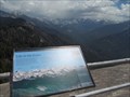 view gallery view galleryNW20.3 km | Moro Rock Orientation - Sequoia Nat'l Park, CA USA in Orientation Tables Some time and effort to get here but inspirational. Really brings home the correlation between our mountains and our water. posted by: sbcamper location: California date approved: 07/08/2015 last visited: 07/31/2023 |
 view gallery view galleryNW20.4 km |  Moro Rock Dept'Inter - Sequoia Nat'l Park - CA Moro Rock Dept'Inter - Sequoia Nat'l Park - CA
in U.S. Benchmarks Probably not where one might think. It is at the base of the steps, near the bathrooms. posted by: sbcamper location: California date approved: 07/15/2015 last visited: 08/08/2018 |
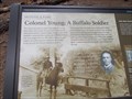 view gallery view galleryNW21.1 km |  First Superintendent of Sequoia N. Park - Col. Charles Young - First Superintendent of Sequoia N. Park - Col. Charles Young -
in First of its Kind First commanded a calvary unit here as a Capt. in 1903.
His unit was primarily Buffalo soldiers. posted by: sbcamper location: California date approved: 05/27/2015 last visited: never |
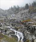 view gallery view galleryNW21.2 km |  Tokopah Falls - Sequoia National Park, CA Tokopah Falls - Sequoia National Park, CA
in Waterfalls The Tokopah Falls is located at the end of the 1.7 mile Tokopah Valley Trail, which begins at the Lodgepole Campground in Sequoia National Park, CA. posted by: Merlin-N-Mim location: California date approved: 10/25/2009 last visited: 06/14/2014 |
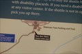
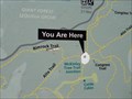 view gallery view galleryNW21.2 km |  You Are Here - McKinley Tree Trail Junction, CA You Are Here - McKinley Tree Trail Junction, CA
in 'You Are Here' Maps You Are Here - McKinley Tree Trail Junction posted by: ToRo61 location: California date approved: 11/12/2017 last visited: never |
 view gallery view gallery W21.6 km W21.6 km
| Potwisha - Sequoia National Park - CA in Campgrounds 42 sites. one reserved for host. Oaks and wild grass. 2500 elev.
Southern park entrance. posted by: sbcamper location: California date approved: 07/15/2015 last visited: 09/12/2017 |
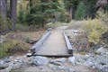 view gallery view galleryNW21.7 km | Tokopah Valley Trail Bridge - Sequoia National Park, California in Hiking Path Footbridges This is a beautiful moderate 1.7 mile hiking trail to Tokopah Falls. The bridge crosses a small stream that cuts the trail. posted by: teeoff2 location: California date approved: 11/06/2008 last visited: 11/07/2010 |
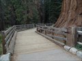 view gallery view galleryNW21.7 km |  General Sherman boardwalk - Sequoia National Park CA General Sherman boardwalk - Sequoia National Park CA
in Non-Coastal Boardwalks Protecting a meadow. Part of the walkway to the giant sequoia. posted by: sbcamper location: California date approved: 05/28/2015 last visited: 07/31/2023 |
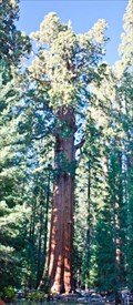 view gallery view galleryNW21.7 km |  General Sherman Tree - Sequoia National Park, California, USA General Sherman Tree - Sequoia National Park, California, USA
in American Guide Series "General Sherman Tree, the largest living thing" posted by: netdust location: California date approved: 05/31/2015 last visited: 07/31/2023 |
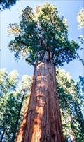 view gallery view galleryNW21.7 km |  General Sherman: World's Largest (not Tallest) Tree - Sequoia N.P., California, USA General Sherman: World's Largest (not Tallest) Tree - Sequoia N.P., California, USA
in Roadside Attractions The largest known living single stem tree on earth, named after a Civil War General. posted by: netdust location: California date approved: 05/31/2015 last visited: 01/14/2024 |
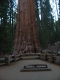 view gallery view galleryNW21.7 km |  General Sherman General Sherman
in Exceptional Trees The General Sherman Giant Sequoia is located in Sequuoia National park, California. posted by: Jagman714 location: California date approved: 12/12/2006 last visited: 07/31/2023 |
 view gallery view galleryNW21.7 km | ") Sequoia National Park Sequoia National Park
in National Parks (U.S.) The world's largest trees posted by: Bernd das Brot Team location: California date approved: 05/17/2008 last visited: 07/31/2023 |
 view gallery view gallery N21.9 km N21.9 km
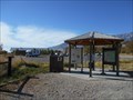
|  Eastern Sierra Visitor Center, Inyo N. F. - Long Pine CA Eastern Sierra Visitor Center, Inyo N. F. - Long Pine CA
in Tourist Information Centers - Visitor Centers Thirteen of the peaks over 14,000 feet are in Inyo County. Permits are required for Wilderness access and trails.
There is a picnic area, bookstore and gift shop, area maps. posted by: sbcamper location: California date approved: 08/14/2022 last visited: never |
 view gallery view galleryNW21.9 km | General Sherman Tree - Sequoia National Park, California in 'You Are Here' Maps The short hike to the General Sherman tree starts with this You are Here sign posted by: teeoff2 location: California date approved: 11/03/2008 last visited: 08/08/2018 |
|