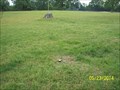
 view gallery view gallery SW2.7 km SW2.7 km
|   Highest Point in Benton Couny, Arkansas Highest Point in Benton Couny, Arkansas
in Geographic High Points The highest point in the northwest-most county in Arkansas posted by:  MountainWoods MountainWoods location: Arkansas date approved: 05/27/2014 last visited: 05/26/2014 |
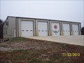 view gallery view gallery W3.1 km W3.1 km
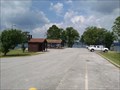
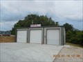
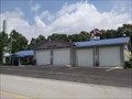
|  NEBCO Fire-EMS Station 2 NEBCO Fire-EMS Station 2
in Firehouses One of 5 fire stations under the same administration in rural Benton County, Arkansas posted by: MountainWoods location: Arkansas date approved: 11/25/2013 last visited: 11/22/2013 |
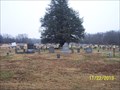
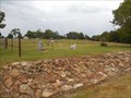
 view gallery view galleryW4.3 km |  Ruddick Cemetery - Garfield, AR Ruddick Cemetery - Garfield, AR
in Churchyard Cemeteries A large, well-kept churchyard cemetery in rural Benton County, Arkansas posted by: MountainWoods location: Arkansas date approved: 11/22/2013 last visited: 11/22/2013 |
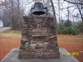 view gallery view galleryW4.3 km |  Bell at Ruddick Cemetery, near Garfield, AR Bell at Ruddick Cemetery, near Garfield, AR
in Bells Unusual to find a bell at a cemetery, but here is one at Ruddick Cemetery in rural Benton County, Arkanas posted by: MountainWoods location: Arkansas date approved: 11/23/2013 last visited: 11/22/2013 |
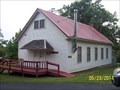
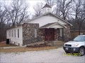 view gallery view galleryW4.3 km |  Reddick Assembly of God Church near Garfield, AR Reddick Assembly of God Church near Garfield, AR
in Country Churches An Assembly of God Church with churchyard cemetery in rural Benton County, Arkansas posted by: MountainWoods location: Arkansas date approved: 11/23/2013 last visited: 11/22/2013 |
 view gallery view galleryW4.3 km |  Ruddick Cemetery near Garfield, AR Ruddick Cemetery near Garfield, AR
in Worldwide Cemeteries A large, well-kept cemetery in rural Benton County, Arkansas posted by: MountainWoods location: Arkansas date approved: 11/25/2013 last visited: 11/22/2013 |
 view gallery view galleryW4.5 km |  Ruddick One-Room School near Garfield, AR Ruddick One-Room School near Garfield, AR
in One-Room Schoolhouses A former one-room school in rural Benton County, Arkansas posted by: MountainWoods location: Arkansas date approved: 11/23/2013 last visited: 11/22/2013 |
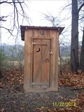 view gallery view galleryW4.5 km |  Ruddick School Outhouse, near Garfield, AR Ruddick School Outhouse, near Garfield, AR
in Outhouses A well-built outhouse behind the former one-room Ruddick School near Garfield, Arkansas posted by: MountainWoods location: Arkansas date approved: 11/23/2013 last visited: 11/22/2013 |
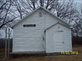 view gallery view galleryW4.5 km |  Ruddick School - Garfield, AR Ruddick School - Garfield, AR
in Former Schools A former one-room school in rural Benton County, Arkansas posted by: MountainWoods location: Arkansas date approved: 11/23/2013 last visited: 11/22/2013 |
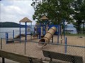 view gallery view gallery E5 km E5 km
|  Playground at Dam Site Park - Eureka Springs, AR Playground at Dam Site Park - Eureka Springs, AR
in Public Playgrounds A small playground at the public Dam Site Park in Carroll County, Arkansas posted by: MountainWoods location: Arkansas date approved: 06/13/2015 last visited: 06/12/2015 |
 view gallery view galleryE5 km |  Dam Site Park - Eureka Springs, AR Dam Site Park - Eureka Springs, AR
in Public Access Lands A park at the Beaver Lake Dam in Carroll County, Arkansas posted by: MountainWoods location: Arkansas date approved: 06/16/2015 last visited: 06/12/2015 |
 view gallery view galleryE5.1 km |  BEAVER DAM - River Gauge BEAVER DAM - River Gauge
in River Gauges Beaver Dam River Gauge,Beaver Lake,Arkansas posted by: GEO*Trailblazer 1 location: Arkansas date approved: 01/02/2007 last visited: 03/18/2009 |
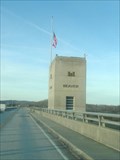
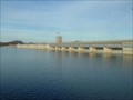 view gallery view galleryE5.1 km |  BEAVER DAM - Dam and Resevior BEAVER DAM - Dam and Resevior
in Water Dams Beaver Lake and Dam Arkansas posted by: GEO*Trailblazer 1 location: Arkansas date approved: 01/13/2007 last visited: 06/12/2015 |
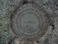
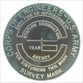 view gallery view galleryE5.1 km |  ARMY CORPS OF ENGINEERS (BEAVER DAM) ARMY CORPS OF ENGINEERS (BEAVER DAM)
in U.S. Benchmarks ARMY CORPS OF ENGINEERS, BEAVER DAM,ARKANSAS posted by: GEO*Trailblazer 1 location: Arkansas date approved: 01/02/2007 last visited: 03/18/2009 |
 view gallery view gallery SE6 km SE6 km
|  MUNDELL - AZIMUTH ARKANSAS MUNDELL - AZIMUTH ARKANSAS
in Azimuth Benchmarks MUNDELL AZIMUTH MARK BEAVER LAKE ARKANSAS posted by: GEO*Trailblazer 1 location: Arkansas date approved: 11/27/2007 last visited: 11/27/2007 |
 view gallery view gallery NW6.1 km NW6.1 km
| GF 0968 X-309 1989 Benton County Arkansas in U.S. Benchmarks Nat'l Geodetic Survey Vertical Control Mark posted by: rainwolf420 location: Arkansas date approved: 11/01/2008 last visited: 01/01/2013 |
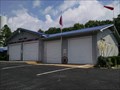
 view gallery view gallery N6.1 km N6.1 km
| NEBCO No. 4 in Firehouses One of 5 fire stations under the same administration in rural Benton County, Arkansas posted by: MountainWoods location: Arkansas date approved: 07/17/2013 last visited: 07/16/2013 |
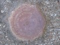 view gallery view gallerySE6.3 km | MUNDELL - TRIANGULATION STATION in U.S. Benchmarks Designation: MUNDELL
Marker Type: Triangulation Station Disk
Setting: Set into the top of a round concrete monument posted by: GEO*Trailblazer 1 location: Arkansas date approved: 11/30/2007 last visited: 11/30/2007 |
 view gallery view galleryN6.4 km | Clantonville Cemetery near Garfield, Arkansas in Worldwide Cemeteries A small, well-kept cemetery along US-62 in rural Benton County, Arkansas posted by: MountainWoods location: Arkansas date approved: 07/19/2013 last visited: 07/16/2013 |
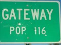 view gallery view galleryNW6.6 km |  Gateway,Arkansas/USA Gateway,Arkansas/USA
in Population Signs Welcome to Gateway Arkansas Gateway to the Ozarks.
Elevation: 1581 posted by: GEO*Trailblazer 1 location: Arkansas date approved: 11/25/2007 last visited: 02/05/2013 |
 view gallery view galleryE6.6 km |  Grassy Knob Volunteer Fire Association & Community Center - Eureka Springs, AR Grassy Knob Volunteer Fire Association & Community Center - Eureka Springs, AR
in Municipal Community Centers A community center building that serves two purposes in rural Carroll County, Arkansas posted by: MountainWoods location: Arkansas date approved: 06/13/2015 last visited: 06/12/2015 |
 view gallery view galleryE6.6 km | Grassy Knob Volunteer Fire Association & Community Center in Firehouses A rural Arkansas fire station that also serves as the community center in Carroll County, Arkansas posted by: MountainWoods location: Arkansas date approved: 06/12/2015 last visited: 06/12/2015 |
 view gallery view gallery S6.8 km S6.8 km
| Coal Gap School - LaRue, AR in One-Room Schoolhouses A beautifully-maintained former one-room school in Benton County, Arkansas posted by: MountainWoods location: Arkansas date approved: 05/27/2014 last visited: 05/23/2014 |
 view gallery view galleryS6.8 km |  Coal Gap School in LaRue, AR Coal Gap School in LaRue, AR
in Wikipedia Entries A beautifully-maintained former one-room school in Benton County, Arkansas posted by: MountainWoods location: Arkansas date approved: 05/23/2014 last visited: 05/23/2014 |
 view gallery view galleryS6.8 km |  Coal Gap School - LaRue, Arkansas Coal Gap School - LaRue, Arkansas
in U.S. National Register of Historic Places A beautifully-maintained former one-room school in Benton County, Arkansas posted by: MountainWoods location: Arkansas date approved: 05/23/2014 last visited: 05/23/2014 |
|