 view gallery view gallery N3.2 km N3.2 km
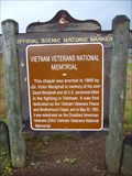
|   Vietnam Veterans National Memorial Vietnam Veterans National Memorial
in New Mexico Historical Markers A New Mexico OSHM on US-64 at milepost 277. posted by:  leadhiker leadhiker location: New Mexico date approved: 10/27/2011 last visited: 04/08/2007 |
 view gallery view galleryN3.4 km |  Vietnam War Memorial, State Park, Angel Fire, NM, USA Vietnam War Memorial, State Park, Angel Fire, NM, USA
in Vietnam War Memorials Vietnam Veterans Memorial State Park, Angel Fire, New Mexico. posted by: HANSENNI location: New Mexico date approved: 05/13/2009 last visited: 04/08/2007 |
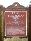 view gallery view gallery W4.2 km W4.2 km
| Palo Flechado Pass in New Mexico Historical Markers A New Mexico OSHM along US-64 at milepost 272. posted by: leadhiker location: New Mexico date approved: 10/27/2011 last visited: never |
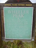 view gallery view galleryN10.8 km | Wheeler Peak in New Mexico Historical Markers A New Mexico OSHM on US-64 at milepost 282. posted by: leadhiker location: New Mexico date approved: 10/27/2011 last visited: 08/09/2014 |
 view gallery view gallery NE13.8 km NE13.8 km
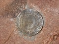
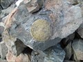
|  CLEAR NO 2 - Colfax County, New Mexico CLEAR NO 2 - Colfax County, New Mexico
in U.S. Benchmarks A reference mark for triangulation station CLEAR on the summit of Mt. Phillips. posted by:  Tom.dog Tom.dog location: New Mexico date approved: 11/04/2022 last visited: never |
 view gallery view galleryNE13.8 km |  Mount Phillips - Philmont Scout Ranch Mount Phillips - Philmont Scout Ranch
in Mountain Summits Summit of Mt. Phillips in the South Country of Philmont Scout Ranch. It is named for oil baron Waite Phillips. posted by: SSG Scout location: New Mexico date approved: 10/17/2008 last visited: 07/30/2012 |
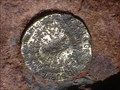 view gallery view galleryNE13.8 km | CLEAR (GM0792) - Colfax County , NM in U.S. Benchmarks Located on Top of Mt. Phillips posted by: DayTrekkers location: New Mexico date approved: 05/07/2008 last visited: 07/30/2012 |
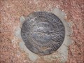 view gallery view galleryNE13.8 km | CLEAR NO 1 - Colfax County, New Mexico in U.S. Benchmarks A reference mark for triangulation station CLEAR on the summit of Mt. Phillips. posted by: Tom.dog location: New Mexico date approved: 11/04/2022 last visited: never |
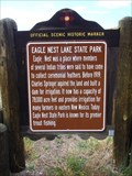 view gallery view galleryN15.6 km | Eagle Nest Lake State Park in New Mexico Historical Markers A New Mexico OSHM on US-64 at milepost 287. posted by: leadhiker location: New Mexico date approved: 10/27/2011 last visited: 07/28/2020 |
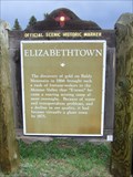 view gallery view galleryN15.9 km | Elizabethtown in New Mexico Historical Markers A New Mexico OSHM on the northeast corner of US-64 and NM-38. posted by: leadhiker location: New Mexico date approved: 10/27/2011 last visited: never |
 view gallery view galleryN16.1 km |  Eagle Nest, NM 87718 Eagle Nest, NM 87718
in U.S. Post Offices Caught this one while geocaching on day off from Philmont Training Center. posted by: SM741 location: New Mexico date approved: 12/13/2008 last visited: 07/20/2015 |
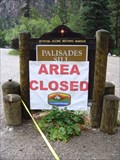 view gallery view galleryNE18.7 km | Palisades Sill in New Mexico Historical Markers A New Mexico OSHM on US-64 at milepost 294. posted by: leadhiker location: New Mexico date approved: 10/27/2011 last visited: 07/08/2023 |
 view gallery view gallery E19.3 km E19.3 km
| Black Mountain, Philmont Scout Ranch, New Mexico in Mountain Summits Located on Philmont Scout Ranch, Cimmeron, New Mexico
posted by:  Web-ling Web-ling location: New Mexico date approved: 10/14/2006 last visited: 06/25/2005 |
 view gallery view gallery NW19.8 km NW19.8 km
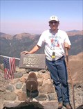
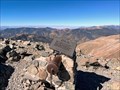
|  Wheeler Peak - Highest in New Mexico Wheeler Peak - Highest in New Mexico
in Summit Registers The highest point in New Mexico! posted by: Web-ling location: New Mexico date approved: 04/03/2006 last visited: 07/16/2019 |
 view gallery view galleryNW19.8 km |  Wheeler Peak (New Mexico) Wheeler Peak (New Mexico)
in Wikipedia Entries Wheeler Peak is the highest peak in New Mexico posted by: Web-ling location: New Mexico date approved: 12/04/2009 last visited: 07/16/2023 |
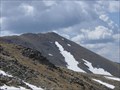
 view gallery view galleryNW19.8 km |  Highest Point in New Mexico (Wheeler Peak) Highest Point in New Mexico (Wheeler Peak)
in Geographic High Points At an elevation of 13,161 ft., the summit of Wheeler Peak, in the Sangre de Cristo Mountains, is the highest point in the state of New Mexico. posted by: hykesj location: New Mexico date approved: 10/22/2023 last visited: 07/16/2019 |
 view gallery view galleryNW19.8 km | WHEELER Reference Mark - Taos County, New Mexico in U.S. Benchmarks This is one of the reference marks for USGS benchmark WHEELER, located atop Wheeler Peak. posted by: Tom.dog location: New Mexico date approved: 11/16/2022 last visited: 07/16/2019 |
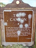 view gallery view galleryW21.1 km | Taos Canyon in New Mexico Historical Markers A New Mexico OSHM along US-64 at milepost 258. posted by: leadhiker location: New Mexico date approved: 10/27/2011 last visited: never |
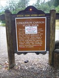 view gallery view galleryNE21.6 km | Cimarron Canyon State Park in New Mexico Historical Markers A New Mexico OSHM on US-64 at milepost 296. posted by: leadhiker location: New Mexico date approved: 10/27/2011 last visited: never |
 view gallery view galleryNW21.7 km | Kachina Peak in Mountain Summits Kachina Peak posted by: rybozz location: New Mexico date approved: 07/20/2009 last visited: never |
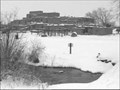 view gallery view galleryW22.9 km |  Taos Pueblo Taos Pueblo
in World Heritage Sites Taos Pueblo (or Pueblo de Taos), continuously inhabited for more than 1000 years, is the ancient town of the Northern Tiwa speaking tribe of the Pueblo people, Native Americans. posted by: RakeInTheCache location: New Mexico date approved: 11/05/2006 last visited: 10/29/2019 |
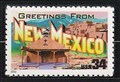 view gallery view galleryW23 km |  Taos Pueblo, New Mexico Taos Pueblo, New Mexico
in Philatelic Photographs A view of Taos Pueblo against a backdrop of the Sangre de Cristo Mountains is featured on this 2002 “Greetings from New Mexico” stamp. posted by: hykesj location: New Mexico date approved: 04/08/2019 last visited: 10/29/2019 |
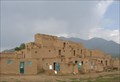 view gallery view galleryW23 km |  Taos Pueblo Taos Pueblo
in U.S. National Register of Historic Places A World Heritage Site and a National Historic Landmark posted by: heringermr location: New Mexico date approved: 08/29/2007 last visited: 10/29/2019 |
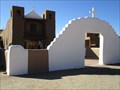
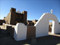 view gallery view galleryW23 km |  San Geronimo Church (from the left side) - Taos, NM San Geronimo Church (from the left side) - Taos, NM
in Picture Perfect Postcards A postcard with the San Geronimo Church at the Taos Pueblo. posted by: saopaulo1 location: New Mexico date approved: 01/06/2017 last visited: 10/29/2019 |
 view gallery view galleryW23 km |  Taos Church - Taos, NM Taos Church - Taos, NM
in Ansel Adams Photo Hunt The Taos Church photo at the Taos Pueblo. posted by: saopaulo1 location: New Mexico date approved: 01/13/2017 last visited: 10/29/2019 |
|