 view gallery view gallery NW6.4 km NW6.4 km
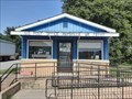
|   Maysville, AR 72747 Maysville, AR 72747
in U.S. Post Offices A small post office in a small town; Maysville, Arkansas posted by:  The Snowdog The Snowdog location: Arkansas date approved: 07/18/2020 last visited: never |
 view gallery view gallery N6.4 km N6.4 km
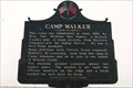
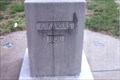
|  Camp Walker - Maysville, AR Camp Walker - Maysville, AR
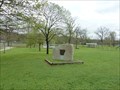
in American Civil War Monuments and Memorials A huge fort use to stand here. A Confederate camp to recruit Indians and westerners. Raised ground in background is a remnant. posted by: YoSam. location: Arkansas date approved: 01/08/2015 last visited: 07/17/2020 |
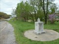
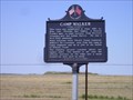 view gallery view galleryN6.4 km |  Camp Walker Camp Walker
in Arkansas Historical Markers Enjoy a country drive and pick up a cache and a waymark. posted by:  *TnT* *TnT* location: Arkansas date approved: 04/28/2007 last visited: 06/12/2021 |
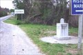
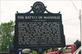 view gallery view galleryNW6.4 km | The Battle of Maysville - Maysville, AR in American Civil War Monuments and Memorials A second conflict in the area of Pea Ridge, months after the major battle posted by: YoSam. location: Arkansas date approved: 01/08/2015 last visited: never |
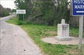
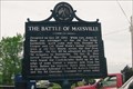 view gallery view galleryNW6.4 km |  The Battle of Maysville - Maysville, AR The Battle of Maysville - Maysville, AR
in Battlefields A second conflict in the area of Pea Ridge, months after the major battle posted by: YoSam. location: Arkansas date approved: 06/14/2023 last visited: never |
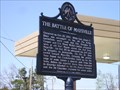 view gallery view galleryNW6.4 km | The Battle of Maysville in Arkansas Historical Markers A country drive will net you another Arkansas Historical Marker Waymark. posted by: *TnT* location: Arkansas date approved: 04/28/2007 last visited: 05/15/2007 |
 view gallery view gallery E10 km E10 km
|  Decatur Cemetery - Decatur, AR - USA Decatur Cemetery - Decatur, AR - USA
in Worldwide Cemeteries Decatur Cemetery is on the north side of Roller Ave. in far northwest Arkansas. posted by: Max and 99 location: Arkansas date approved: 09/30/2020 last visited: never |
 view gallery view gallery SE12.6 km SE12.6 km
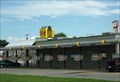
|  Sonic - S. Gentry Blvd - Gentry, AR Sonic - S. Gentry Blvd - Gentry, AR
in Sonic Drive In Restaurants This is the Sonic Drive In location in Gentry, AR. posted by: retail96 location: Arkansas date approved: 10/31/2018 last visited: never |
 view gallery view gallery NE13.2 km NE13.2 km
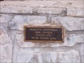
|  Gravette Centennial Time Capsule Gravette Centennial Time Capsule
in Time Capsules Placed in 1993. To be opened in 2043. It just appears to be in honor of the Gravette Centennial. Behind the capsule is a plane and plaque in honor of Captin Field Kindley, a WW1 "Ace". posted by: maddlove location: Arkansas date approved: 01/23/2006 last visited: 04/21/2007 |
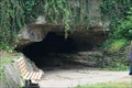 view gallery view galleryNE15 km | ") Old Spanish Treasure Cave Old Spanish Treasure Cave
in Cave Entrances (Natural) Cavern open for tours. posted by: wardnkathy location: Arkansas date approved: 06/04/2014 last visited: never |
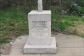
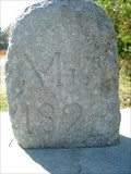 view gallery view galleryN16.9 km |  BONDARY MONUMENT MO ARK OK BONDARY MONUMENT MO ARK OK
in U.S. Historic Survey Stones and Monuments ANOTHER TRI STATE BOUNDARY STONE.
MISSOURI ARKANSAS AND OKLAHOMA.
posted by: GEO*Trailblazer 1 location: Missouri date approved: 10/29/2006 last visited: 07/17/2020 |
 view gallery view galleryN16.9 km |  BORDER CROSSING MO AR OK BORDER CROSSING MO AR OK
in Border Crossings This Monument marks the SW corner of Missouri The NE corner of Oklahoma and the NW corner of Arkansas posted by: GEO*Trailblazer 1 location: Missouri date approved: 12/02/2007 last visited: 07/17/2020 |
 view gallery view galleryN16.9 km |  Oklahoma - Missouri - Arkansas Tripoint Oklahoma - Missouri - Arkansas Tripoint
in Tripoints and Multipoints This marker designates the point where the U.S. states of Oklahoma, Arkansas and Missouri meet. posted by: silverquill location: Oklahoma date approved: 04/22/2013 last visited: 07/17/2020 |
 view gallery view galleryN16.9 km |  OKARMO Corner OKARMO Corner
in Wikipedia Entries Original marker, the upgraded, then improved again, without removing the old...point where Arkansas, Missouri and Oklahoma meet. posted by: YoSam. location: Arkansas date approved: 04/14/2019 last visited: 07/17/2020 |
 view gallery view galleryN16.9 km |  Tri-State Marker - Southwest City, MO and AR and OK Tri-State Marker - Southwest City, MO and AR and OK
in Roadside Attractions Original marker, the upgraded, then improved again, without removing the old...point where Arkansas, Missouri and Oklahoma meet. posted by: YoSam. location: Arkansas date approved: 04/14/2019 last visited: 07/17/2020 |
 view gallery view galleryN16.9 km |  Tri-State Marker - Southwest City, MO Tri-State Marker - Southwest City, MO
in Missouri Historical Markers The exact spot where three states meet and the western end to the Mason-Dixon Line. posted by: YoSam. location: Missouri date approved: 11/06/2008 last visited: 07/17/2020 |
 view gallery view galleryN16.9 km | Tr-State Marker - Benton County, AR in Arkansas Historical Markers The point where three states meet, NW of Maysville, AR. posted by: YoSam. location: Arkansas date approved: 11/08/2008 last visited: 07/17/2020 |
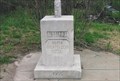
 view gallery view galleryN16.9 km |  Tri-State Boundary Marker - Southwest City, MO Tri-State Boundary Marker - Southwest City, MO
in Lions Clubs International Markers Actually the state is Arkansas - Missouri - & Oklahoma since it sits on the point where all three meet. posted by: YoSam. location: Missouri date approved: 01/15/2015 last visited: 07/17/2020 |
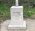
 view gallery view galleryN16.9 km |  Tri-State Identification Marker - 1915 & 1955 - Southwest City, MO & AR & OK Tri-State Identification Marker - 1915 & 1955 - Southwest City, MO & AR & OK
in Dated Architectural Structures Multifarious Original marker, the upgraded, then improved again, without removing the old...point where Arkansas, Missouri and Oklahoma meet. posted by: YoSam. location: Arkansas date approved: 04/14/2019 last visited: 07/17/2020 |
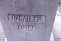 view gallery view galleryN16.9 km |  Tri-State Monument - Delaware County, OK Tri-State Monument - Delaware County, OK
in Oklahoma Historical Markers Where three states meet, southern limits of Southwest City, MO and northwest of Maryville, AR. posted by: YoSam. location: Oklahoma date approved: 11/06/2008 last visited: 07/17/2020 |
 view gallery view galleryN16.9 km |  Border Stone - Tri-State ~ MO, OK, AR Border Stone - Tri-State ~ MO, OK, AR
in Public Land Survey Marks Just S. of Southwest City in Missouri. posted by: YoSam. location: Missouri date approved: 11/11/2009 last visited: 07/17/2020 |
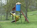 view gallery view galleryNE17.4 km |  City Park Playground - Sulphur Springs, AR City Park Playground - Sulphur Springs, AR
in Public Playgrounds This historic 65-acre park is located on Route 59 in the small town of Sulphur Springs, Benton County, Arkansas. posted by: silverquill location: Arkansas date approved: 04/23/2013 last visited: never |
 view gallery view galleryNE17.4 km |  Sulphur Springs Park Reserve - Sulphur Springs. AR Sulphur Springs Park Reserve - Sulphur Springs. AR
in U.S. National Register of Historic Places This historic 65-acre park is located along Butler Creek in the small town of Sulphur Springs, Benton County, Arkansas. posted by: silverquill location: Arkansas date approved: 04/22/2013 last visited: never |
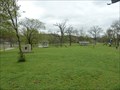 view gallery view galleryNE17.4 km |  City Park - Sulphur Springs, AR City Park - Sulphur Springs, AR
in Municipal Parks and Plazas This historic 65-acre park is located on Route 59 in the small town of Sulphur Springs, Benton County, Arkansas. posted by: silverquill location: Arkansas date approved: 04/22/2013 last visited: never |
 view gallery view gallery S18 km S18 km
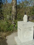
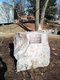
|  Dr. Dorothy J. Woodland and Dr. Irvin A. Wills Dr. Dorothy J. Woodland and Dr. Irvin A. Wills
in Citizen Memorials This large boulder honors two past JBU science professors. It stands outside the main entrance to the Bell Science Hall on the beautiful John Brown University campus. posted by: Where's George location: Arkansas date approved: 02/23/2018 last visited: never |
|