 view gallery view gallery SW21.1 km SW21.1 km
|   Balch Park Campground Balch Park Campground
in Campgrounds A Tulare County Campground, situated within Mountain Home State Demonstration Forest. Sequoia Redwoods, two fishing ponds, nice camping areas and wildlife abound. Watch out for bears at night! posted by:  senoritafish senoritafish location: California date approved: 08/06/2013 last visited: never |
 view gallery view gallery W25.7 km W25.7 km
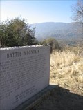
|  Battle Mountain - Tulare County, CA Battle Mountain - Tulare County, CA
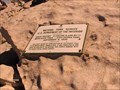
in E Clampus Vitus Historical Markers Dr. Samuel Gregg George Chapter 1855
E Clampus Vitus posted by: fishingwishing location: California date approved: 12/28/2007 last visited: never |
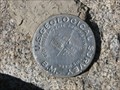 view gallery view gallery E28.5 km E28.5 km
|  Trail Peak Benchmark Trail Peak Benchmark
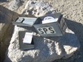
in U.S. Benchmarks U. S. Geological Survey Benchmark at summit of Trail Peak in Golden Trout Wilderness of Inyo National Forest. posted by:  CoachDave45 CoachDave45 location: California date approved: 08/11/2010 last visited: never |
 view gallery view gallery NE30.4 km NE30.4 km
| Mount Langley - California in U.S. Benchmarks A benchmark located on the summit of Mount Langley in the Sierra mountain range of California. posted by: Touchstone location: California date approved: 09/01/2009 last visited: 09/07/2016 |
 view gallery view galleryNE30.4 km |  Mount Langley Mount Langley
in Mountain Summits The lowest of the 14'ers in California, as well as technically the easiest to reach and ascend. posted by: Touchstone location: California date approved: 08/31/2009 last visited: never |
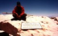
 view gallery view galleryNE30.4 km |  Mount Langley - California Mount Langley - California
in Summit Registers Located on the summit of Mount Langley (14,022 feet) in the Southern Sierra of California. posted by: Touchstone location: California date approved: 08/30/2009 last visited: never |
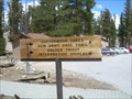 view gallery view galleryNE31.2 km |  Golden Trout Wilderness, Horshoe Meadow Trailhead - California Golden Trout Wilderness, Horshoe Meadow Trailhead - California
in Hiking and walking trailheads Horseshoe Meadow Trailhead offers a relatively easy access point to Golden Trout Wilderness, but also the Southern portion of John Muir Wilderness. posted by: Touchstone location: California date approved: 09/02/2009 last visited: never |
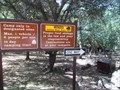
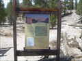 view gallery view galleryNE31.2 km |  Horshoe Meadow Trailhead - Lone Pine, California Horshoe Meadow Trailhead - Lone Pine, California
in 'You Are Here' Maps A large map at the Horshoe Meadow Trailhead that gives would-be backpackers and hikers some idea of where they are. posted by: Touchstone location: California date approved: 09/02/2009 last visited: never |
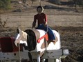 view gallery view galleryW31.4 km |  Cowboy Mailbox - Springville, CA Cowboy Mailbox - Springville, CA
in Themed Homemade Mailboxes Cowboy riding his horse mailbox on Balch Park Road above Springville, CA posted by: fishingwishing location: California date approved: 12/16/2007 last visited: 12/19/2007 |
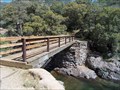 view gallery view gallery NW32.2 km NW32.2 km
|  Marble fork, Kaweah River - Rio del Morte - Tulare CA Marble fork, Kaweah River - Rio del Morte - Tulare CA
in Hiking Path Footbridges About 35 feet long and 4 feet wide. The bridge crosses about 20 -25 feet above the river. Visitors are warned regarding steep access and the possibility of hypothermia that this river is to be respected. posted by: sbcamper location: California date approved: 05/20/2015 last visited: never |
 view gallery view galleryNE32.2 km | Mt. Whitney in Mountain Summits Mt Whitney is the highest point in the contiguous United States. posted by: wilsonjw location: California date approved: 09/08/2005 last visited: 08/01/2013 |
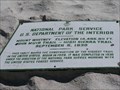
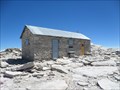 view gallery view galleryNE32.2 km |  Smithsonian Institution Shelter - Mt. Whitney, CA Smithsonian Institution Shelter - Mt. Whitney, CA
in U.S. National Register of Historic Places Mt. Whitney Smithsonian Research Facility
Sequoia National Park, CA posted by: fresgo location: California date approved: 08/06/2013 last visited: 08/05/2013 |
 view gallery view galleryNE32.2 km |  Highest Point in California (Mt Whitney) Highest Point in California (Mt Whitney)
in Geographic High Points Mt Whitney at 14,505 feet is the highest point in California, as well as the lower 48 states and both Tulare and Inyo counties. posted by: Rumpled location: California date approved: 10/20/2008 last visited: 08/04/2013 |
 view gallery view galleryNE32.2 km | Highest Point in Tulare County (Mt Whitney) in Geographic High Points Mt Whitney at 14,505 feet is the highest point in Tulare County, as well as the lower 48 states, the state of California and Inyo County. posted by: Rumpled location: California date approved: 10/20/2008 last visited: 08/04/2013 |
 view gallery view galleryNE32.2 km | Highest Point in Inyo County (Mt Whitney) in Geographic High Points Mt Whitney at 14,505 feet is the highest point in Inyo County, as well as the lower 48 states, the state of California and Tulare County.
posted by: Rumpled location: California date approved: 10/20/2008 last visited: 08/01/2013 |
 view gallery view galleryNW32.5 km | Buckeye Flat - Sequoia National Park CA in Campgrounds 14 day limit. no showers. Shady at 2,820 ft. elev. 860 meters.
29 spaces posted by: sbcamper location: California date approved: 05/21/2015 last visited: never |
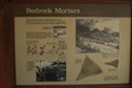 view gallery view galleryNW32.8 km |  Indian Acorn Grinding Mortars- Sequoia National Park, California Indian Acorn Grinding Mortars- Sequoia National Park, California
in New World Ancient Evidence These bedrock grinding mortars are located near Hospital Rock in Sequoia National Park posted by: teeoff2 location: California date approved: 11/04/2008 last visited: 09/23/2016 |
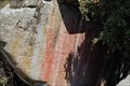 view gallery view galleryNW32.8 km |  Hospital Rock Pictographs - Sequoia National Park, California Hospital Rock Pictographs - Sequoia National Park, California
in Pictographs Very nice pictographs located at this site in Sequoia National park. posted by: teeoff2 location: California date approved: 10/29/2008 last visited: 09/23/2016 |
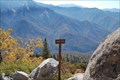 view gallery view galleryNW33.2 km |  Eagle View High Sierra Trail - Sequoia National Park, California Eagle View High Sierra Trail - Sequoia National Park, California
in Scenic Overlooks The High Sierra trail is a beautiful trail that spans the Sierra mountains and runs for many miles. This view is just a mile or so from Crescent meadow in Sequoia National Park. posted by: teeoff2 location: California date approved: 11/06/2008 last visited: 11/06/2008 |
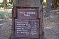 view gallery view galleryNW34 km | High Sierra Trail, Crescent Meadow - Sequoia National Park, Ca. in Hiking and walking trailheads A 72.2 mile trail that crosses the Sierra's to Mount Whitney. posted by: teeoff2 location: California date approved: 03/06/2009 last visited: 03/06/2009 |
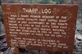 view gallery view galleryNW34 km |  Tharp's Log - Sequoia National Park, California Tharp's Log - Sequoia National Park, California
in Treehouses A giant red wood log used as a home for Hale Tharp, the first European settler to homestead in the Sequoia Giant Forest.
This house is on a nice trail that starts at the Cresent Meadow Picnic area in Sequoia National park. posted by: teeoff2 location: California date approved: 10/30/2008 last visited: 10/18/2009 |
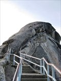 view gallery view galleryNW34.1 km |  Moro Rock Stairway - Sequoia National Park, CA Moro Rock Stairway - Sequoia National Park, CA
in Outdoor Stairways The Moro Rock Stairway is an almost 400 step climb to the summit of Moro Rock in Sequoia National Park. posted by: Merlin-N-Mim location: California date approved: 10/24/2009 last visited: 01/14/2024 |
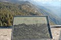 view gallery view galleryNW34.1 km |  Morro Rock - Sequoia National Park, California Morro Rock - Sequoia National Park, California
in Orientation Tables At elevation 6738, these tables show the great features of the surrounding mountains. posted by: teeoff2 location: California date approved: 11/04/2008 last visited: 08/08/2018 |
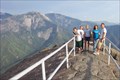 view gallery view galleryNW34.1 km | Moro Rock, California in Mountain Summits Quick, steep climb up a rock staircase from the parking lot to Moro Rock, Sequoia National Park. posted by: guesszoo location: California date approved: 09/09/2005 last visited: 01/14/2024 |
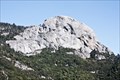 view gallery view galleryNW34.3 km |  Moro Rock - Sequoia National Park, California, USA Moro Rock - Sequoia National Park, California, USA
in Places of Geologic Significance A trail including a historic stairway lead up to the top this granite monolith. posted by: netdust location: California date approved: 06/22/2015 last visited: 08/08/2018 |
|