 view gallery view gallery N10.1 km N10.1 km
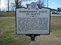
|   Independent State of Scott - 1F32 - Huntsville, TN Independent State of Scott - 1F32 - Huntsville, TN
in Tennessee Historical Markers This historical marker is located along Highway 63 in Huntsville, Tennessee. posted by:  Marine Biologist Marine Biologist location: Tennessee date approved: 12/28/2008 last visited: 12/28/2008 |
 view gallery view gallery W10.3 km W10.3 km
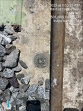
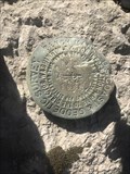
|  T 096 (GB0906) - Scott County, TN T 096 (GB0906) - Scott County, TN
in U.S. Benchmarks An easy to spot but not so easy to get to USC& G Benchmark Disk right off Hwy 27 in Scott County. Plenty of parking next to it but it's a scramble up some loose RR gravel to get to it! posted by: Team Geologynut location: Tennessee date approved: 09/07/2023 last visited: never |
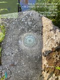 view gallery view galleryW10.3 km | S 196 (GB0905) - Scott County, TN in U.S. Benchmarks An easy to find USC&G Benchmark Disk in a bridge abutment just off Hwy 27 in Scott County. PLenty of parking a few feet from the bridge. posted by: Team Geologynut location: Tennessee date approved: 09/07/2023 last visited: never |
 view gallery view gallery SW16.9 km SW16.9 km
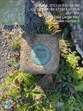
| 65 9 1 (GB0891) Sunbright, Morgan County, TN in U.S. Benchmarks A Tennessee Division of Geology W.P.A station disk in Sunbright, TN. Plenty of parking right across the street from it. posted by: Team Geologynut location: Tennessee date approved: 09/07/2023 last visited: never |
 view gallery view galleryW17.5 km |  Christ Church Episcopal - Rugby Colony Historic District - Rugby, TN Christ Church Episcopal - Rugby Colony Historic District - Rugby, TN
in NRHP Historic Districts - Contributing Buildings Christ Church Episcopal is on the guided tour of Historic Rugby, and is IMHO one of the highlights of the contributing buildings in this historic district. posted by: ggmorton location: Tennessee date approved: 06/14/2021 last visited: 09/03/2007 |
 view gallery view galleryW17.5 km |  Memorial Window - Christ Church Episcopal, Rugby, TN - USA Memorial Window - Christ Church Episcopal, Rugby, TN - USA
in Stained Glass Windows A memorial stained glass window in the the apse of the Christ Church Episcopal in historic Rugby, TN. posted by: ggmorton location: Tennessee date approved: 06/14/2021 last visited: 09/03/2007 |
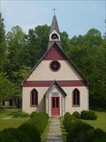
 view gallery view galleryW17.5 km |  Christ Church Episcopal - Rugby, TN Christ Church Episcopal - Rugby, TN
in Anglican and Episcopal Churches Christ Church Episcopal was built in 1887 in Rugby, TN and been in use since that time. posted by: ggmorton location: Tennessee date approved: 06/14/2021 last visited: 09/03/2007 |
 view gallery view galleryW17.5 km |  Christ Church Episcopal - Rugby, TN Christ Church Episcopal - Rugby, TN
in This Old Church This historic Episcopal church in Rugby, TN is still in use to this day and has been in use since 1887. posted by: ggmorton location: Tennessee date approved: 06/14/2021 last visited: 09/03/2007 |
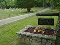 view gallery view galleryW17.7 km |  Laurel Dale Cemetery - Rugby, TN Laurel Dale Cemetery - Rugby, TN
in Worldwide Cemeteries Rugby's Laurel Dale Cemetery is just off the main road in Rugby, TN. posted by: ggmorton location: Tennessee date approved: 06/16/2021 last visited: 09/03/2007 |
 view gallery view galleryN19.8 km | U 197 (GB0948) - Oneida, Scott County, TN in U.S. Benchmarks An easy to find USG&C Benchmark Disk mounted vertically in a building in Oneida, TN. Plenty of parking at building. posted by: Team Geologynut location: Tennessee date approved: 09/07/2023 last visited: never |
 view gallery view gallery S20.1 km S20.1 km
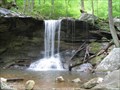
|  Emory Gap Falls Emory Gap Falls
in Waterfalls Emory Gap Falls is another beautiful waterfall in Frozen Head State Park, Wartburg TN. posted by: Team Geologynut location: Tennessee date approved: 04/08/2007 last visited: 10/26/2012 |
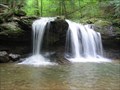 view gallery view galleryS20.4 km | Debord Falls in Waterfalls A beautiful waterfall in Frozen Head State Park, Wartburg TN. posted by: Team Geologynut location: Tennessee date approved: 04/08/2007 last visited: 04/08/2007 |
 view gallery view gallery NW20.9 km NW20.9 km
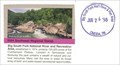
|  Big South Fork National River and Recreation Area - Oneida TN Big South Fork National River and Recreation Area - Oneida TN
in Wikipedia Entries Encompassing 125,000 acres of the Cumberland Plateau, Big South Fork National River and Recreation Area protects the free-flowing Big South Fork of the Cumberland River and its tributaries. posted by:  Don.Morfe Don.Morfe location: Tennessee date approved: 09/09/2023 last visited: 09/09/2023 |
 view gallery view galleryNW20.9 km |  Big South Fork National River and Recreation Area - Oneida, TN Big South Fork National River and Recreation Area - Oneida, TN
in NPS Passport Cancellation Stations A NPS Cancellation stamp may be obtained inside the Visitor Center at the Big South Fork National River and Recreation Area located at 4564 Leatherwood Road, Oneida, TN 37841 posted by: Don.Morfe location: Tennessee date approved: 10/08/2023 last visited: 10/08/2023 |
 view gallery view galleryNW20.9 km | ") Big South Fork National River and Recreation Area - Oneida, TN Big South Fork National River and Recreation Area - Oneida, TN
in National Parks (U.S.) Encompassing 125,000 acres of the Cumberland Plateau, Big South Fork National River and Recreation Area protects the free-flowing Big South Fork of the Cumberland River and its tributaries. posted by: Don.Morfe location: Tennessee date approved: 12/12/2019 last visited: 10/28/2021 |
 view gallery view galleryNW20.9 km |  Big South Fork National River and Recreation Area - Oneida TN Big South Fork National River and Recreation Area - Oneida TN
in National Parks of the World Encompassing 125,000 acres of the Cumberland Plateau, Big South Fork National River and Recreation Area protects the free-flowing Big South Fork of the Cumberland River and its tributaries. posted by: Don.Morfe location: Tennessee date approved: 09/09/2023 last visited: 09/09/2023 |
 view gallery view galleryNW20.9 km |  Big South Fork National River and Recreation Area - Oneida, TN Big South Fork National River and Recreation Area - Oneida, TN
in Official Local Tourism Attractions Encompassing 125,000 acres of the Cumberland Plateau, Big South Fork National River and Recreation Area protects the free-flowing Big South Fork of the Cumberland River and its tributaries. posted by: Don.Morfe location: Tennessee date approved: 09/09/2023 last visited: 09/09/2023 |
 view gallery view galleryNW20.9 km |  Ranger Station at Big South Fork National River and Recreation Area - Oneida, TN Ranger Station at Big South Fork National River and Recreation Area - Oneida, TN
in Ranger Stations A Ranger Station is inside the visitor center at the Big South Fork National River and Recreation Area located at 4564 Leatherwood Road, Oneida, TN 37841 posted by: Don.Morfe location: Tennessee date approved: 09/15/2023 last visited: 09/15/2023 |
 view gallery view galleryNW20.9 km |  Big South Fork National River and Recreation Area - Oneida, TN Big South Fork National River and Recreation Area - Oneida, TN
in Satellite Imagery Oddities Encompassing 125,000 acres of the Cumberland Plateau, Big South Fork National River and Recreation Area protects the free-flowing Big South Fork of the Cumberland River and its tributaries. posted by: Don.Morfe location: Tennessee date approved: 09/09/2023 last visited: 09/09/2023 |
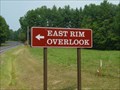 view gallery view galleryNW21.4 km |  Big South Fork East Rim Overlook Big South Fork East Rim Overlook
in Scenic Overlooks An overlook on the east side of the Big South Fork National River & Recreation Area. posted by: ggmorton location: Tennessee date approved: 09/12/2007 last visited: 10/18/2012 |
 view gallery view gallery E23.5 km E23.5 km
| GB0558 (F 236) USC&GS Benchmark Disk - Royal Blue, Campbell Co , TN in U.S. Benchmarks An easy to find USGS benchmark disk in the Royal Blue area of Campbell County TN. posted by: Team Geologynut location: Tennessee date approved: 01/08/2021 last visited: never |
 view gallery view galleryE24 km | GB0560 (N 236) USC&GS Benchmark Disk - Campbell Co , TN in U.S. Benchmarks An easy to find USC&GS benchmark disk in Campbell County TN. posted by: Team Geologynut location: Tennessee date approved: 12/14/2020 last visited: never |
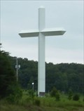 view gallery view galleryE24.8 km |  Huge Cross - Pioneer, TN Huge Cross - Pioneer, TN
in Roadside Attractions This huge cross is located just off I-75 in Pioneer, TN. There is no signage indicating who erected it or who owns the property it is on. posted by: onfire4jesus location: Tennessee date approved: 07/25/2008 last visited: 08/23/2015 |
 view gallery view galleryE24.8 km |  Huge Cross - Pioneer, TN Huge Cross - Pioneer, TN
in Christian Crosses Alongside I-75 near Pioneer Tennessee, a huge, white 50' cross stands. There is no signage or any other indication of who erected the cross or whose property it stands on. posted by: onfire4jesus location: Tennessee date approved: 07/26/2008 last visited: 08/23/2015 |
 view gallery view galleryS25.1 km |  Subway - Mill Street - Wartburg, TN Subway - Mill Street - Wartburg, TN
in Subway Restaurants This Subway is located in a small (two store) strip mall on Mill Street, just off of US 27, Wartburg, TN. posted by: Lat34North location: Tennessee date approved: 10/25/2011 last visited: 10/24/2011 |
|