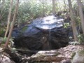
 view gallery view gallery SE1.9 km SE1.9 km
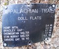
|   Doll Flats - NC Doll Flats - NC
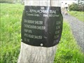
in Appalachian Trail Trail sign at Doll Flats which is popular camping location. posted by:  vhasler vhasler location: North Carolina date approved: 03/28/2012 last visited: never |
 view gallery view gallery S3.1 km S3.1 km
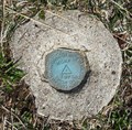
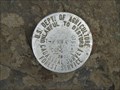
|  GA3371 - Hump 1975 - Avery county, NC GA3371 - Hump 1975 - Avery county, NC
in U.S. Benchmarks Benchmark set on top of Hump Mountain by NORTH CAROLINA GEODETIC SURVEY in 1975. Along the Appalachian Trail. posted by: vhasler location: North Carolina date approved: 03/24/2012 last visited: never |
 view gallery view gallery E3.9 km E3.9 km
|  Elk Park, NC 28622 Elk Park, NC 28622
in U.S. Post Offices The Elk Park Post Office on US 19E. posted by: papermanone & catlover location: North Carolina date approved: 08/05/2007 last visited: never |
 view gallery view gallery NW5 km NW5 km
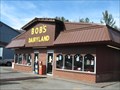
|  Bob's Dairyland - Roan Mountain, TN Bob's Dairyland - Roan Mountain, TN
in Ice Cream Parlors Local eating establishment that sells shakes, cones, sundaes featuring both soft serve and hand dipped ice cream posted by: vhasler location: Tennessee date approved: 04/04/2009 last visited: never |
 view gallery view gallery SW5.5 km SW5.5 km
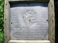
| Overmountain Men-Appalachian Trail, Yellow Mountain Gap-Avery NC in Appalachian Trail Marker is near Valley, North Carolina, in Avery County. Marker can be reached from Roaring Creek Road.are on the Appalachian Trail in the Pishah National Forest. Closest town is Roan Mountain, Tennessee. Marker is in this post office area: Newland NC posted by:  Countrydragon Countrydragon location: North Carolina date approved: 12/18/2009 last visited: 12/18/2009 |
 view gallery view gallery NE5.5 km NE5.5 km
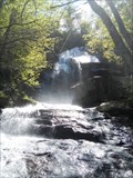
|  Jones Falls - Tennessee Jones Falls - Tennessee
in Waterfalls Small cascading waterfall on spur off Appalachian Trail. posted by: vhasler location: Tennessee date approved: 05/19/2013 last visited: never |
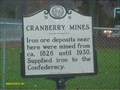 view gallery view galleryE5.5 km |  CRANBERRY MINES CRANBERRY MINES
in North Carolina Historical Markers Located right next to highway 19 and historic cranberry high school posted by: Countrydragon location: North Carolina date approved: 10/31/2009 last visited: 04/13/2023 |
 view gallery view galleryE5.6 km |  Cranberry Iron Mine Iron for the Confederacy - Elk Park NC Cranberry Iron Mine Iron for the Confederacy - Elk Park NC
in Civil War Discovery Trail Sites During the Civil War, natural resources such as salt, lead, and iron were highly prized commodities in the Confederacy. The government relied especially on small rural ironworks to manufacture cannons, swords, and firearms. posted by: Don.Morfe location: North Carolina date approved: 04/20/2020 last visited: 10/08/2021 |
 view gallery view galleryE5.6 km | Cranberry Iron Mine-Iron for the Confederacy - Elk Park NC in U.S. Civil War Sites During the Civil War, natural resources such as salt, lead, and iron were highly prized commodities in the Confederacy. The government relied especially on small rural ironworks to manufacture cannons, swords, and firearms. posted by: Don.Morfe location: North Carolina date approved: 04/14/2023 last visited: 04/13/2023 |
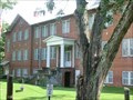 view gallery view galleryE5.6 km |  Former Cranberry High School - Elk Park NC Former Cranberry High School - Elk Park NC
in Former Schools Construction on Cranberry High School began in 1923 and the new building opened in time for the 1924-1925 school year. The school operated continuously until 1968. posted by: Don.Morfe location: North Carolina date approved: 04/13/2023 last visited: 04/13/2023 |
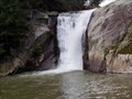 view gallery view galleryNE5.8 km |  Elk River Falls - Banner Elk, North Carolina Elk River Falls - Banner Elk, North Carolina
in Swimming Holes This swimming hole is located outside of Banner Elk, between North Carolina and Tennessee on Elk River Road. posted by: macleod1 location: North Carolina date approved: 08/12/2008 last visited: 04/04/2009 |
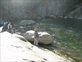 view gallery view galleryNE6 km |  Elk River and Falls - Elk Park, NC Elk River and Falls - Elk Park, NC
in Fishing Holes Trout fly fishmen were lining Elk River and the falls due to the cold water release of brook, brown, rainbow trout by the N.C. Wildlife Resources Commission posted by: vhasler location: North Carolina date approved: 04/04/2009 last visited: never |
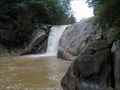 view gallery view galleryNE6 km | Elk Falls in Waterfalls Elk Falls is located in Elk Falls Park near Elk Park and Newland, NC. posted by: papermanone & catlover location: North Carolina date approved: 08/05/2007 last visited: 04/04/2009 |
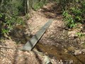 view gallery view gallery N6.3 km N6.3 km
|  Footbridge on AT in Buck Mtn Area - Tennessee Footbridge on AT in Buck Mtn Area - Tennessee
in Hiking Path Footbridges Newer Tennessee Eastman Hiking Club footbridge design across a small runoff stream in the remote Buck Mountain area posted by: vhasler location: Tennessee date approved: 04/04/2009 last visited: never |
 view gallery view galleryNE6.8 km | Mountaineer Falls along AT - Tennessee in Waterfalls A small waterfall along the Appalachian Trail, thus giving the nearby backcountry shelter its name. posted by: vhasler location: Tennessee date approved: 04/04/2009 last visited: never |
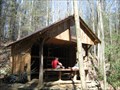 view gallery view galleryNE6.8 km |  Mountaineer Falls Shelter - Appalachian Trail - Tennessee Mountaineer Falls Shelter - Appalachian Trail - Tennessee
in Remote Backcountry Shelters One of the newest shelters on the Appalachian Trail (AT) constructed by the Tennessee Eastman Hiking Club posted by: vhasler location: Tennessee date approved: 04/04/2009 last visited: never |
 view gallery view galleryNE6.8 km | Mountaineer Falls Shelter - Tennessee in Appalachian Trail One of the newest shelters on the AT constructed by the Tennessee Eastman Hiking Club posted by: vhasler location: Tennessee date approved: 04/11/2009 last visited: never |
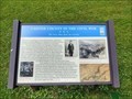 view gallery view gallery W6.9 km W6.9 km
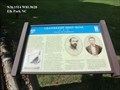
|  Carter County in the Civil War - Roan Mountain, TN Carter County in the Civil War - Roan Mountain, TN
in Signs of History Carter County, especially the area around Roan Mountain, suffered from the effects of occupation during the war. Residents were divided in their support of the Union and the Confederacy, and raids were commonplace. posted by: bluesnote location: Tennessee date approved: 07/01/2020 last visited: 07/01/2020 |
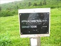 view gallery view gallerySW8.9 km | Spur trail split for Grassy Ridge - TN/NC border in Appalachian Trail AT Trail Marker showing the spur trail up to Grassy Ridge posted by: vhasler location: North Carolina date approved: 06/05/2010 last visited: never |
 view gallery view gallerySW9 km |  Grassy Ridge - 6160' - North Carolina Grassy Ridge - 6160' - North Carolina
in Mountain Summits Grassy Ridge is the highest natural bald in the Roan highlands posted by: vhasler location: North Carolina date approved: 06/06/2010 last visited: never |
 view gallery view gallerySW9.2 km | Forest Service T-P96A - Grassy Ridge in U.S. Benchmarks Survey Mark on Grassy Ridge posted by: vhasler location: North Carolina date approved: 06/06/2010 last visited: 06/02/2017 |
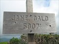 view gallery view gallerySW9.3 km |  Jane Bald - 5807' - Roan Highlands - TN/NC border Jane Bald - 5807' - Roan Highlands - TN/NC border
in Elevation Signs Jane Bald along the Appalachian Trail posted by: vhasler location: North Carolina date approved: 06/06/2010 last visited: 06/26/2016 |
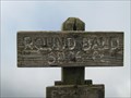 view gallery view gallerySW9.8 km | Round Bald - 5826' - Near Carvers Gap, NC/TN in Elevation Signs Round Bald is the first natural summit reached along the AT northbound from Carvers Gap posted by: vhasler location: North Carolina date approved: 06/06/2010 last visited: never |
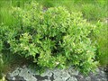 view gallery view gallerySW10 km |  Huckleberries at Round Bald - TN/NC border Huckleberries at Round Bald - TN/NC border
in Berry Picking Smaller than blueberries, huckleberries grow wild on the Roan balds posted by: vhasler location: North Carolina date approved: 06/17/2010 last visited: never |
 view gallery view gallerySW10.3 km | Carvers Gap - Roan Mountains - TN/NC Border in Appalachian Trail The AT crosses the highway at Carvers Gap posted by: vhasler location: Tennessee date approved: 06/16/2010 last visited: never |
|