 view gallery view gallery W0.2 km W0.2 km
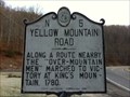
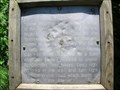
|   Yellow Mountain Road | N-5 Yellow Mountain Road | N-5
in North Carolina Historical Markers US 19 East at Roaring Creek bridge southwest of Frank posted by:  3newsomes 3newsomes location: North Carolina date approved: 12/31/2011 last visited: 06/25/2020 |
 view gallery view gallery NE4 km NE4 km
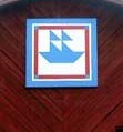
|  Battleship Barn-Newland, NC Battleship Barn-Newland, NC
in Painted Barn Quilts Battleship pattern on a red barn out in Avery County North Carolina. posted by: Countrydragon location: North Carolina date approved: 12/10/2009 last visited: 12/10/2009 |
 view gallery view gallery NW7.4 km NW7.4 km
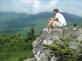
|  Grassy Ridge - 6160' - North Carolina Grassy Ridge - 6160' - North Carolina
in Mountain Summits Grassy Ridge is the highest natural bald in the Roan highlands posted by:  vhasler vhasler location: North Carolina date approved: 06/06/2010 last visited: never |
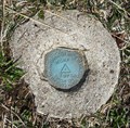
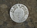 view gallery view galleryNW7.4 km |  Forest Service T-P96A - Grassy Ridge Forest Service T-P96A - Grassy Ridge
in U.S. Benchmarks Survey Mark on Grassy Ridge posted by: vhasler location: North Carolina date approved: 06/06/2010 last visited: 06/02/2017 |
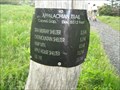
 view gallery view galleryNW7.7 km |  Overmountain Men-Appalachian Trail, Yellow Mountain Gap-Avery NC Overmountain Men-Appalachian Trail, Yellow Mountain Gap-Avery NC
in Appalachian Trail Marker is near Valley, North Carolina, in Avery County. Marker can be reached from Roaring Creek Road.are on the Appalachian Trail in the Pishah National Forest. Closest town is Roan Mountain, Tennessee. Marker is in this post office area: Newland NC posted by: Countrydragon location: North Carolina date approved: 12/18/2009 last visited: 12/18/2009 |
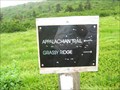 view gallery view galleryNW8 km | Spur trail split for Grassy Ridge - TN/NC border in Appalachian Trail AT Trail Marker showing the spur trail up to Grassy Ridge posted by: vhasler location: North Carolina date approved: 06/05/2010 last visited: never |
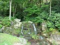 view gallery view galleryNE8.5 km |  Waterfalls Park AKA Bobby McLean Memorial Park - Newland NC Waterfalls Park AKA Bobby McLean Memorial Park - Newland NC
in Waterfalls See several cascades that fall a total of about 50 feet in a lovely park setting with a trail and picnic tables. It's located on NC Highway 194 in Newland. The Waterfalls Park is also known as Bobby McLean Memorial Park. posted by: Don.Morfe location: North Carolina date approved: 12/17/2020 last visited: 10/19/2021 |
 view gallery view gallery N8.5 km N8.5 km
| GA3371 - Hump 1975 - Avery county, NC in U.S. Benchmarks Benchmark set on top of Hump Mountain by NORTH CAROLINA GEODETIC SURVEY in 1975. Along the Appalachian Trail. posted by: vhasler location: North Carolina date approved: 03/24/2012 last visited: never |
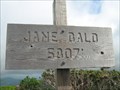 view gallery view galleryNW8.7 km |  Jane Bald - 5807' - Roan Highlands - TN/NC border Jane Bald - 5807' - Roan Highlands - TN/NC border
in Elevation Signs Jane Bald along the Appalachian Trail posted by: vhasler location: North Carolina date approved: 06/06/2010 last visited: 06/26/2016 |
 view gallery view gallery SW9.3 km SW9.3 km
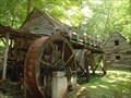
|  Dellinger Mill, Bakersville, NC Dellinger Mill, Bakersville, NC
in U.S. National Register of Historic Places Grist Mill built in 1901. Currently being restored by the great grandson of the original builder. posted by: PFF location: North Carolina date approved: 07/20/2009 last visited: 08/22/2014 |
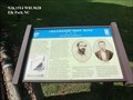
 view gallery view gallery SE9.3 km SE9.3 km
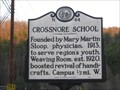
| Crossnore School N44 in North Carolina Historical Markers Founded in 1913, The Crossnore School is a private, non-profit children's home and school in the western North Carolina mountains. posted by: Beagle-1 location: North Carolina date approved: 04/22/2008 last visited: 11/27/2011 |
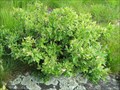 view gallery view galleryNW9.5 km |  Huckleberries at Round Bald - TN/NC border Huckleberries at Round Bald - TN/NC border
in Berry Picking Smaller than blueberries, huckleberries grow wild on the Roan balds posted by: vhasler location: North Carolina date approved: 06/17/2010 last visited: never |
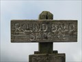 view gallery view galleryNW9.5 km | Round Bald - 5826' - Near Carvers Gap, NC/TN in Elevation Signs Round Bald is the first natural summit reached along the AT northbound from Carvers Gap posted by: vhasler location: North Carolina date approved: 06/06/2010 last visited: never |
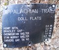 view gallery view galleryN9.8 km | Doll Flats - NC in Appalachian Trail Trail sign at Doll Flats which is popular camping location. posted by: vhasler location: North Carolina date approved: 03/28/2012 last visited: never |
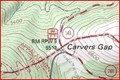 view gallery view galleryNW10 km |  Carvers Gap - 5512' - TN/NC Border Carvers Gap - 5512' - TN/NC Border
in Border Crossings Carvers Gap is the pass through the Roan highlands posted by: vhasler location: North Carolina date approved: 06/08/2010 last visited: 06/26/2020 |
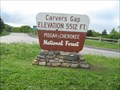 view gallery view galleryNW10 km | Carvers Gap - 5512' - TN/NC Border in Elevation Signs Carvers Gap is the pass through the Roan highlands posted by: vhasler location: North Carolina date approved: 06/08/2010 last visited: 12/19/2015 |
 view gallery view galleryNW10 km | Carvers Gap - Roan Mountains - TN/NC Border in Appalachian Trail The AT crosses the highway at Carvers Gap posted by: vhasler location: Tennessee date approved: 06/16/2010 last visited: never |
 view gallery view galleryNW10 km |  Carvers Gap - 5512' - TN/NC Border Carvers Gap - 5512' - TN/NC Border
in Named Mountain Gaps Carvers Gap is the route through the Roan highlands posted by: vhasler location: North Carolina date approved: 06/08/2010 last visited: 12/19/2015 |
 view gallery view galleryNE10.8 km |  Cranberry Iron Mine Iron for the Confederacy - Elk Park NC Cranberry Iron Mine Iron for the Confederacy - Elk Park NC
in Civil War Discovery Trail Sites During the Civil War, natural resources such as salt, lead, and iron were highly prized commodities in the Confederacy. The government relied especially on small rural ironworks to manufacture cannons, swords, and firearms. posted by: Don.Morfe location: North Carolina date approved: 04/20/2020 last visited: 10/08/2021 |
 view gallery view galleryNE10.8 km | Cranberry Iron Mine-Iron for the Confederacy - Elk Park NC in U.S. Civil War Sites During the Civil War, natural resources such as salt, lead, and iron were highly prized commodities in the Confederacy. The government relied especially on small rural ironworks to manufacture cannons, swords, and firearms. posted by: Don.Morfe location: North Carolina date approved: 04/14/2023 last visited: 04/13/2023 |
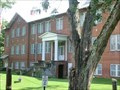 view gallery view galleryNE10.8 km |  Former Cranberry High School - Elk Park NC Former Cranberry High School - Elk Park NC
in Former Schools Construction on Cranberry High School began in 1923 and the new building opened in time for the 1924-1925 school year. The school operated continuously until 1968. posted by: Don.Morfe location: North Carolina date approved: 04/13/2023 last visited: 04/13/2023 |
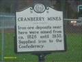 view gallery view galleryNE10.8 km | CRANBERRY MINES in North Carolina Historical Markers Located right next to highway 19 and historic cranberry high school posted by: Countrydragon location: North Carolina date approved: 10/31/2009 last visited: 04/13/2023 |
 view gallery view galleryN10.8 km |  Elk Park, NC 28622 Elk Park, NC 28622
in U.S. Post Offices The Elk Park Post Office on US 19E. posted by: papermanone & catlover location: North Carolina date approved: 08/05/2007 last visited: never |
 view gallery view gallery E11.1 km E11.1 km
|  Sarah Malinda Blalock-A Woman of War- - Linville NC Sarah Malinda Blalock-A Woman of War- - Linville NC
in Citizen Memorials Keith Blalock was an avowed Unionist. He enlisted in the 26th North Carolina Infantry on March 20, 1862. He hoped to get close enough to the Union lines to desert. Malinda Blalock enlisted in the same day, concealing her identity as a woman. posted by: Don.Morfe location: North Carolina date approved: 01/10/2023 last visited: 01/10/2023 |
 view gallery view galleryE11.1 km | A Woman of War-Sarah Malinda Blalock - Linville NC in U.S. Civil War Sites Malinda Blalock enlisted in the same day (March 20, 1862), concealing her identity as a woman and passing herself off as Sam Blalock, Keith’s younger brother. posted by: Don.Morfe location: North Carolina date approved: 04/21/2023 last visited: 04/21/2023 |
|