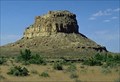
 view gallery view gallery NW15.8 km NW15.8 km
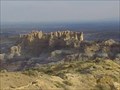
|   Chaco Culture National Historical Park Chaco Culture National Historical Park
in World Heritage Sites Chaco was the cultural center of the Anasazi world. posted by:  culpc culpc location: New Mexico date approved: 09/13/2005 last visited: 04/17/2019 |
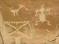 view gallery view galleryNW18.5 km |  Chaco Rock Art Chaco Rock Art
in Pictographs Lots of nice pictographs. posted by:  kingbee kingbee location: New Mexico date approved: 03/09/2009 last visited: 05/26/2012 |
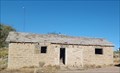 view gallery view gallery N48 km N48 km
|  Abandoned Structure - Bloomfield, NM, USA Abandoned Structure - Bloomfield, NM, USA
in Unoccupied Buildings, Shacks, and Cabins This abandoned structure is just off Highway 550 - in Bloomfield, New Mexico. posted by: The Snowdog location: New Mexico date approved: 10/16/2023 last visited: never |
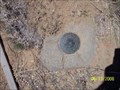
 NW50.4 km |  De-Na-Zin Wilderness (Bisti Badlands) De-Na-Zin Wilderness (Bisti Badlands)
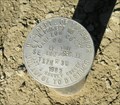
in U.S. Benchmarks U.S. General Land Office Survey Marker For Bisti posted by:  TheOrdinaryHiker TheOrdinaryHiker location: New Mexico date approved: 06/12/2019 last visited: never |
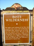 view gallery view galleryNW55.5 km |  Bisti Wilderness Bisti Wilderness
in New Mexico Historical Markers A New Mexico OSHM is at the intersection of State Highway 371 at milepost 77, and County Road 7250. posted by: leadhiker location: New Mexico date approved: 06/09/2011 last visited: 06/14/2011 |
 view gallery view galleryN62.1 km |  Angel Peak Angel Peak
in Scenic Overlooks A nice area to walk around. posted by: kingbee location: New Mexico date approved: 07/28/2007 last visited: 04/21/2010 |
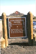
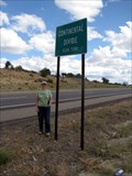 view gallery view gallery E62.4 km E62.4 km
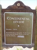
|  Continential Divide Elevation 7380 in New Mexico Continential Divide Elevation 7380 in New Mexico
in Elevation Signs This is the official highway sign that marks the Continental Divide on Hwy 550. posted by: Queens Blessing location: New Mexico date approved: 10/07/2011 last visited: 12/30/2020 |
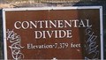 view gallery view galleryE62.4 km | Continental Divide - N. of Cuba, New Mexico - 7,379' in Elevation Signs The spot where water goes this way and that. posted by: YoSam. location: New Mexico date approved: 08/06/2016 last visited: 08/12/2022 |
 view gallery view galleryE62.4 km |  Continental Divide - N. of Cuba, New Mexico, USA Continental Divide - N. of Cuba, New Mexico, USA
in Watershed Markers and Monuments The spot where water goes this way and that. posted by: YoSam. location: New Mexico date approved: 10/04/2017 last visited: 08/12/2022 |
 view gallery view galleryE62.4 km | Continental Divide - N. of Cuba, NM in New Mexico Historical Markers The spot where water goes this way and that. posted by: YoSam. location: New Mexico date approved: 03/28/2009 last visited: 08/12/2022 |
 view gallery view galleryN63.4 km | Kutz NM GN0657 in U.S. Benchmarks An ancient Indian Road. posted by: kingbee location: New Mexico date approved: 03/09/2009 last visited: 07/03/2009 |
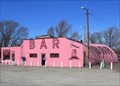 view gallery view gallery S70.7 km S70.7 km
|  Tomahawk Bar Tomahawk Bar
in Quonset Huts Along Route 66 in western New Mexico, the Tomahawk Bar is an operating roadside bar located in a loud-pink quonset hut. It's hard to miss. I'll bet it even glows in the dark! posted by: TravisGood location: New Mexico date approved: 03/18/2007 last visited: 07/21/2010 |
 view gallery view galleryS70.7 km |  Tomahawk Bar Tomahawk Bar
in Route 66 - The Mother Road Along Route 66 east of Gallup, New Mexico, the Tomahawk Bar is an operating roadside bar located in a loud-pink quonset hut. posted by: TravisGood location: New Mexico date approved: 03/18/2007 last visited: 04/15/2017 |
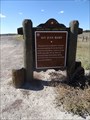 view gallery view galleryE71.1 km | San Juan Basin - Cuba, NM in New Mexico Historical Markers New Mexico Historical Marker located in a roadside pullout northwest of Cuba on the north side of US 550, providing some background about the San Juan Basin. posted by: QuarrellaDeVil location: New Mexico date approved: 10/14/2016 last visited: 08/12/2022 |
 view gallery view gallery SE72.9 km SE72.9 km
| Cabezon Community Reservoir in U.S. Benchmarks Pipe cap marker on south end of earthen dam southwest of San Luis, NM. 14 miles southwest of US550 between San Ysidro and Cuba. posted by: Bosque Bill location: New Mexico date approved: 02/27/2007 last visited: never |
 view gallery view gallery SW75.5 km SW75.5 km
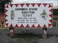
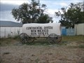
| 7245 ft - Continental Divide, NM in Elevation Signs One of many notations of the elevation in this ridge top town. posted by: ChapterhouseInc location: New Mexico date approved: 10/31/2010 last visited: 02/02/2017 |
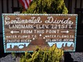
 view gallery view gallerySW75.6 km | 7275 ft - Continental Divide, NM in Elevation Signs One of many notations of the elevation, the wagon is at a gift shop. posted by: ChapterhouseInc location: New Mexico date approved: 10/31/2010 last visited: 10/30/2019 |
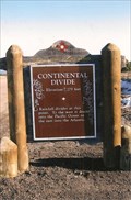
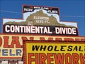 view gallery view gallerySW75.6 km | Continental Divide, New Mexico. 7,295 Feet. in Elevation Signs The Continental Divide at this location is the highest point on Route 66 with an elevation of 7,295 feet. All rain that falls to the left of this location flows into the Pacific, & to the right it flows into the Atlantic, thousands of miles away. posted by: veritas vita location: New Mexico date approved: 10/09/2014 last visited: 08/19/2020 |
 view gallery view gallerySW75.6 km |  U.S. 40 - Continental Divide - New Mexico. U.S. 40 - Continental Divide - New Mexico.
in U.S. 40 - The National Road The Continental Divide, is the highest point on US.40 in New Mexico. Two Historic Markers confirm the elevation as 7,263 feet. The markers are located each side of US.40 at Junction 47, McKinley County, New Mexico. posted by: veritas vita location: New Mexico date approved: 07/24/2015 last visited: 02/01/2020 |
 view gallery view gallerySW75.6 km | Highest Point - Route 66 - Continental Divide, New Mexico, USA. in Route 66 - The Mother Road The Continental Divide at this location is the highest point on Route 66 with an elevation of 7,263 feet. All rain that falls to the left of this location flows into the Pacific, & to the right it flows into the Atlantic, thousands of miles away. posted by: veritas vita location: New Mexico date approved: 10/08/2014 last visited: 10/30/2019 |
 view gallery view gallerySW75.6 km | Continental Divide - McKinley County, New Mexico, USA. in Watershed Markers and Monuments The Continental Divide at this location is the highest point on Route 66 with an elevation of 7,263 feet. All rain that falls to the left of this location flows into the Pacific, & to the right it flows into the Atlantic, thousands of miles away.
Location: New Mexico, United States posted by: veritas vita location: New Mexico date approved: 10/04/2017 last visited: 08/19/2020 |
 view gallery view gallerySW75.6 km |  Historic Route 66 - Continental Divide - New Mexico, USA. Historic Route 66 - Continental Divide - New Mexico, USA.
in National Scenic Byways The Continental Divide at this location is the highest point on Route 66 with an elevation of 7,263 feet. All rain that falls to the left of this location flows into the Pacific, & to the right it flows into the Atlantic, thousands of miles away. posted by: veritas vita location: New Mexico date approved: 10/07/2014 last visited: 10/30/2019 |
 view gallery view gallerySW75.6 km |  Continental Divide Trading Post - Continental Divide, New Mexico, USA. Continental Divide Trading Post - Continental Divide, New Mexico, USA.
in Roadside Attractions The Continental Divide at this location is the highest point on Route 66 with an elevation of 7,263 feet. All rain that falls to the left of this location flows into the Pacific, & to the right it flows into the Atlantic, thousands of miles away. posted by: veritas vita location: New Mexico date approved: 02/05/2015 last visited: 10/30/2019 |
 view gallery view gallerySW75.6 km |  Covered Wagon - Continental Divide, NM Covered Wagon - Continental Divide, NM
in Covered Wagons One of many notations of the elevation, the wagon is at a gift shop. posted by: ChapterhouseInc location: New Mexico date approved: 11/04/2010 last visited: 10/30/2019 |
 view gallery view gallerySW75.6 km |  Continental Divide, NM Continental Divide, NM
in Wikipedia Entries Continental Divide is a village on Interstate 40 where it crosses the continental divide in New Mexico. posted by: rjmcdonough1 location: New Mexico date approved: 08/26/2020 last visited: never |
|