 view gallery view gallery SE1.3 km SE1.3 km
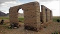
|   Ashford Mills, Death Valley, California Ashford Mills, Death Valley, California
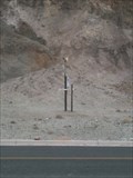
in Ghost Towns From 1914 until 1941, gold ore from the Golden Treasure Mine, five miles to the east was processed in this tiny Death Valley settlement for shipment to a smelter. posted by:  Bernd das Brot Team Bernd das Brot Team location: California date approved: 09/01/2006 last visited: 04/08/2011 |
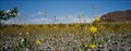 view gallery view gallerySE1.3 km |  Ashford Mills Wild Flower Field, Death Valley, California Ashford Mills Wild Flower Field, Death Valley, California
in Flower Fields Amazing display of desert flowers posted by: Bernd das Brot Team location: California date approved: 09/01/2006 last visited: 02/12/2018 |
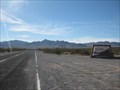
 view gallery view gallery E23.2 km E23.2 km
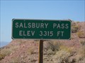
|  Salsbury Pass, CA - 3315 feet Salsbury Pass, CA - 3315 feet
in Elevation Signs This sign is located on a lonely road, heading west, between Shoshone and Badwater. Be sure and look for the nearby geocache - GC10JJF salsbury pass cache. posted by:  Free2bme29 Free2bme29 location: California date approved: 10/14/2009 last visited: 09/14/2021 |
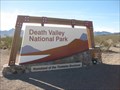 view gallery view galleryE31.9 km |  Death Valley National Park Death Valley National Park
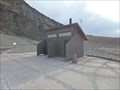
in National Parks of the World The largest park in the lower 48 states has many unique features to explore. This mark is at one of the southern border crossings. posted by: ChapterhouseInc location: California date approved: 01/20/2011 last visited: 08/03/2020 |
 view gallery view galleryE31.9 km |  Death Valley National Park Death Valley National Park
in Wikipedia Entries The largest park in the lower 48 states has many unique features to explore. This mark is at one of the southern border crossings. posted by: ChapterhouseInc location: California date approved: 01/17/2011 last visited: 03/03/2022 |
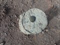 view gallery view gallery N33.8 km N33.8 km
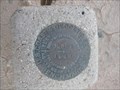
|  NPS Survey Mark DV1 RESET - Dante's View - Death Valley National Park, CA NPS Survey Mark DV1 RESET - Dante's View - Death Valley National Park, CA
in U.S. Benchmarks An unmarked US National Park Service survey mark located just off the parking area of Dante's View in Death Valley National Park, replacing the vandalized DV1. posted by: jiggs11 location: California date approved: 04/20/2017 last visited: 02/09/2017 |
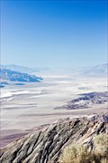 view gallery view galleryN33.8 km |  Mos Eisley - Dante's View, Death Valley, California, USA Mos Eisley - Dante's View, Death Valley, California, USA
in All Things Star Wars Did you know that city of Mos Eisley on Tatooine is really in Badwater Basin? posted by: netdust location: California date approved: 01/04/2015 last visited: 04/07/2022 |
 view gallery view galleryN33.8 km | Dante's View - Death Valley National Park, CA, USA in Wikipedia Entries This panoramic vista, known as Dante's View, is situated atop the Black Mountains and is considered to be one of the great photographic spots in Death Valley. posted by: Chasing Blue Sky location: California date approved: 04/18/2013 last visited: 04/07/2022 |
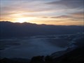 view gallery view galleryN33.8 km |  Dante's View - Death Valley National Park, CA, USA Dante's View - Death Valley National Park, CA, USA
in Scenic Roadside Look-Outs This panoramic vista, known as Dante's View, is situated atop the Black Mountains and is considered to be one of the great photographic spots in Death Valley - and you can drive right to it. posted by: Chasing Blue Sky location: California date approved: 04/18/2013 last visited: 04/07/2022 |
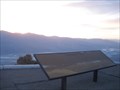
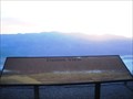 view gallery view galleryN33.8 km |  Dante's View Orientation Table - Death Valley National Park, CA, USA Dante's View Orientation Table - Death Valley National Park, CA, USA
in Orientation Tables This Orientation Table is located on the panoramic vista, known as Dante's View, which is situated atop the Black Mountains and is considered to be one of the great photographic spots in Death Valley - and you can drive right to it. posted by: Chasing Blue Sky location: California date approved: 04/21/2013 last visited: 04/07/2022 |
 N33.8 km | Death Valley National Park: D.V. 2 in U.S. Benchmarks Unspecified NPS marker near PID: GS0907 posted by: [DELETED_USER] location: California date approved: 03/31/2008 last visited: 04/07/2022 |
 view gallery view galleryN33.8 km |  "Looking across desert toward mountains" - Death Valley, California, USA "Looking across desert toward mountains" - Death Valley, California, USA
in Ansel Adams Photo Hunt Ansel Adams took some great shots in Death Valley. posted by: netdust location: California date approved: 01/03/2015 last visited: 04/07/2022 |
 view gallery view gallerySE33.8 km | FT0152 - P684 in U.S. Benchmarks Located in Death Valley National Park along a dirt road. posted by: ChapterhouseInc location: California date approved: 01/30/2011 last visited: 01/19/2011 |
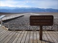
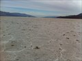
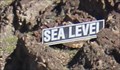 view gallery view galleryN35.4 km | Sea Level - Badwater Basin, Death Valley National Park CA in Elevation Signs At Badwater Basin, a Sea Level sign high on the mountain directly east of the road lets you know how far below sea level you are. posted by: Benchmark Blasterz location: California date approved: 03/29/2016 last visited: 04/07/2022 |
 view gallery view galleryN35.4 km |  Badwater Basin - Death Valley Scenic Byway - Death Valley National Park, CA Badwater Basin - Death Valley Scenic Byway - Death Valley National Park, CA
in National Scenic Byways This is the lowest waymark in North America! posted by: bluesnote location: California date approved: 02/22/2012 last visited: 04/07/2022 |
 view gallery view galleryN35.4 km |  Lowest Weather Station in North America Lowest Weather Station in North America
in Weather Stations Welcome to the lowest weather station in North America! posted by: bluesnote location: California date approved: 02/24/2012 last visited: 01/05/2023 |
 view gallery view galleryN35.4 km |  Western Hemisphere's Lowest Pit Toilet - Death Valley, CA Western Hemisphere's Lowest Pit Toilet - Death Valley, CA
in Roadside Attractions Pit toilets located at 282 Feet below sea level serving the needs of tourists in the Badwater Basin of Death Valley National Park! posted by: jiggs11 location: California date approved: 04/17/2017 last visited: 10/06/2017 |
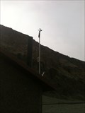 view gallery view galleryN35.4 km | Badwater Weather Station - Death Valley National Park, CA in Weather Stations This is the second lowest weather station in all of North America! posted by: bluesnote location: California date approved: 02/24/2012 last visited: 01/05/2023 |
 view gallery view galleryN35.4 km |  Badwater Basin - Death Valley National Park, CA Badwater Basin - Death Valley National Park, CA
in Official Local Tourism Attractions This is a must see location if you are in Death Valley National Park. posted by: bluesnote location: California date approved: 02/29/2012 last visited: 04/07/2022 |
 view gallery view galleryN35.4 km | Badwater Basin - 282 Feet Below Sea Level - Death Valley National Park, CA in Elevation Signs This sign is located in Death Valley National Park. posted by: Team Min Dawg location: California date approved: 04/26/2010 last visited: 04/07/2022 |
 view gallery view galleryN35.4 km |  Badwater Pool -- Badwater Basin, Death Valley National Park, CA Badwater Pool -- Badwater Basin, Death Valley National Park, CA
in Signs of History One of several interpretive signs at this fascinating area in Death Valley national Park. posted by: Benchmark Blasterz location: California date approved: 03/29/2016 last visited: 04/07/2022 |
 view gallery view galleryN35.4 km |  Best Kept Secret of Badwater Basin Best Kept Secret of Badwater Basin
in Best Kept Secrets Although the famous Bad Water Basin sign is here, there is a less famous sign that people miss while they visit here. All you have to do is look to the east, you will find it. The above coordinates are the best place to view this best kept secret. posted by: bluesnote location: California date approved: 04/09/2012 last visited: 04/07/2022 |
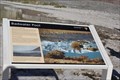
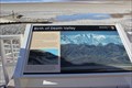 view gallery view galleryN35.4 km | Birth of Death Valley -- Death Valley National Park, CA in Signs of History One of several interpretive signs at this fascinating area in Death Valley National Park. posted by: Benchmark Blasterz location: California date approved: 03/31/2016 last visited: 04/07/2022 |
 view gallery view galleryN35.4 km | But It's a Dry Heat -- Death Valley National Park, CA in Signs of History One of several interpretive signs at this fascinating area in Death Valley National Park. posted by: Benchmark Blasterz location: California date approved: 03/31/2016 last visited: 04/07/2022 |
 view gallery view galleryN35.4 km | Badwater Basin - Death Valley National Park, CA in Wikipedia Entries This is the lowest waymark in North America! posted by: bluesnote location: California date approved: 02/20/2012 last visited: 04/07/2022 |
|