 view gallery view gallery SE4.2 km SE4.2 km
|   San Ildefonso Pueblo San Ildefonso Pueblo
in U.S. National Register of Historic Places The pueblo (Spanish for town) was founded when people came from the Mesa Verde complex in Southern Colorado. posted by:  RakeInTheCache RakeInTheCache location: New Mexico date approved: 11/05/2006 last visited: 11/05/2006 |
 view gallery view gallery S4.8 km S4.8 km
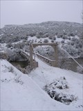
| Otowi Suspension Bridge in U.S. National Register of Historic Places Located along the south side of the highway between Pojoaque and Los Alamos where it crosses the Rio Grande. posted by: RakeInTheCache location: New Mexico date approved: 12/20/2006 last visited: 06/11/2010 |
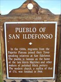 view gallery view gallerySE5 km |  Pueblo of San Ildefonso Pueblo of San Ildefonso
in New Mexico Historical Markers A New Mexico OSHM at main entrance to San Ildefonso Pueblo. posted by:  leadhiker leadhiker location: New Mexico date approved: 10/22/2011 last visited: 05/03/2017 |
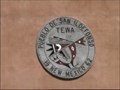
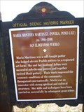 view gallery view gallerySE5.1 km | Maria Montoya Martinez - San Ildefonso Pueblo in New Mexico Historical Markers A New Mexico Historic Women Marker at main entrance to San Ildefonso Pueblo. posted by: leadhiker location: New Mexico date approved: 10/22/2011 last visited: 10/29/2019 |
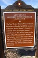 view gallery view gallerySE5.1 km | New Mexico Historic Women Marker Initiative - Santa Fe County, New Mexico in New Mexico Historical Markers This historic marker, interestingly, highlights a historical marker initiative that began in 2005 which is intended to display the contributions of women. posted by: Trail Blaisers location: New Mexico date approved: 08/11/2017 last visited: 10/29/2019 |
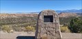
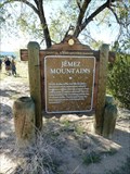 view gallery view gallerySE5.8 km | Jemez Mountains - Santa Fe County, NM in New Mexico Historical Markers Marker is on New Mexico Route 502 at milepost 13.5. posted by: Go Boilers! location: New Mexico date approved: 10/21/2011 last visited: 10/29/2019 |
 view gallery view gallery NE8.2 km NE8.2 km
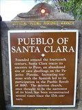
| Pueblo of Santa Clara in New Mexico Historical Markers A New Mexico OSHM on NM 30 at milepost 7. posted by: leadhiker location: New Mexico date approved: 10/22/2011 last visited: 07/22/2011 |
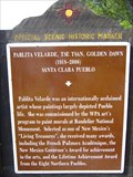
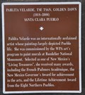 view gallery view galleryNE8.2 km |  Pablita Velarde, Tse Tsan, Golden Dawn ~ Santa Clara Pueblo, New Mexico Pablita Velarde, Tse Tsan, Golden Dawn ~ Santa Clara Pueblo, New Mexico
in Citizen Memorials This New Mexico Historical Marker honoring Pablita Velarde is located on the west side of New Mexico Highway 30 at Gutierrez Drive in Santa Clara Pueblo, New Mexico. posted by: brwhiz location: New Mexico date approved: 02/07/2013 last visited: never |
 view gallery view galleryNE8.2 km | Pablita Velarde, Tse Tsan, Golden Dawn in New Mexico Historical Markers A New Mexico Historic Women Marker on NM 30 at milepost 7. posted by: leadhiker location: New Mexico date approved: 10/22/2011 last visited: 07/22/2011 |
 view gallery view gallery SW8.4 km SW8.4 km
|  Tsankawi Ruins - Bandelier National Monument, NM Tsankawi Ruins - Bandelier National Monument, NM
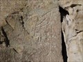
in Pictographs There are a variety of carvings along the trail, including Kokopelli. posted by: Go Boilers! location: New Mexico date approved: 10/31/2011 last visited: 01/14/2023 |
 view gallery view gallerySW8.4 km |  Tsankawi Ruins - Bandelier National Monument, NM Tsankawi Ruins - Bandelier National Monument, NM
in Kokopelli Sightings This Kokopelli was carved by the Tsankawi over 500 years ago. posted by: Go Boilers! location: New Mexico date approved: 11/03/2011 last visited: 01/14/2023 |
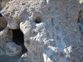 view gallery view gallerySW8.5 km |  Tsankawi Cave - Bandelier National Monument, NM Tsankawi Cave - Bandelier National Monument, NM
in New World Ancient Evidence The Tsankawi section of Bandelier National Monument is located on State Highway 4 twelve miles from the main section of the park. posted by: Go Boilers! location: New Mexico date approved: 10/30/2011 last visited: 01/14/2023 |
 view gallery view gallerySW8.7 km | Clinton P. Anderson - Los Alamos, NM in Citizen Memorials This memorial plaque to Senator Clinton P. Anderson is at a scenic pull out - in Los Alamos, New Mexico. posted by: The Snowdog location: New Mexico date approved: 10/16/2023 last visited: never |
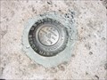 view gallery view gallerySW8.9 km |  USGS Bench Mark 48 GCOC 1 USGS Bench Mark 48 GCOC 1
in U.S. Benchmarks An unlisted USGS bemchmark posted by: Mesa Mike location: New Mexico date approved: 03/20/2008 last visited: never |
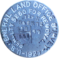 view gallery view gallery W8.9 km W8.9 km
|  East Section Corner, T19N R6E Sections 12 & 13 East Section Corner, T19N R6E Sections 12 & 13
in Public Land Survey Marks Section corner monument for the east section corner of sections 12 and 13 in T19N R6E, New Mexico Meridian. posted by: Mesa Mike location: New Mexico date approved: 02/17/2009 last visited: never |
 view gallery view galleryNE8.9 km |  Santa Clara Pueblo - Española, NM Santa Clara Pueblo - Española, NM
in Nations Within Nations The Santa Clara Pueblo by Española, NM. posted by: saopaulo1 location: New Mexico date approved: 12/27/2016 last visited: never |
 view gallery view gallerySW10.3 km | Los Alamos Scientific Laboratory - Los Alamos NM in U.S. National Register of Historic Places Los Alamos National Laboratory (Los Alamos or LANL for short) is a United States Department of Energy national laboratory initially organized during World War II for the design of nuclear weapons as part of the Manhattan Project. posted by: nomadwillie location: New Mexico date approved: 07/08/2018 last visited: 01/08/2019 |
 view gallery view galleryNE10.3 km | The Bond House in New Mexico Historical Markers Acquired by the city of Española in 1957, the building is used as a museum today. posted by: leadhiker location: New Mexico date approved: 10/22/2011 last visited: 07/22/2011 |
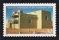 view gallery view galleryNE10.5 km |  Misión Museum y Convento, Española, New Mexico Misión Museum y Convento, Española, New Mexico
in Philatelic Photographs This replica of the Church of San Miguel at San Gabriel stands in the Plaza de Española, and appears on this stamp commemorating the settlement of New Mexico by the Spanish. posted by: hykesj location: New Mexico date approved: 01/28/2019 last visited: never |
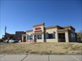 view gallery view galleryNE10.5 km |  Blake's Lotaburger - Espanola, NM Blake's Lotaburger - Espanola, NM
in Burger Shops - Regional Chains A Blake's in Espanola, NM. posted by: saopaulo1 location: New Mexico date approved: 01/13/2017 last visited: never |
 view gallery view galleryNE10.6 km |  Española in Stone - Española, NM Española in Stone - Española, NM
in Satellite Imagery Oddities Espanola in stone in Espanola, NM. posted by: saopaulo1 location: New Mexico date approved: 12/28/2016 last visited: never |
 view gallery view galleryNE10.6 km |  Española - Española, NM Española - Española, NM
in Readable From Above Española in stone in Española, NM. posted by: saopaulo1 location: New Mexico date approved: 12/31/2016 last visited: never |
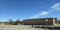 view gallery view galleryNE10.8 km |  Richard L Lucero Center Public Library - Espanola, NM Richard L Lucero Center Public Library - Espanola, NM
in Libraries The Richard L Lucero Center Public Library in Espanola, NM. posted by: saopaulo1 location: New Mexico date approved: 12/28/2016 last visited: never |
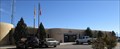 view gallery view galleryNE10.8 km |  Española, NM Española, NM
in City and Town Halls The city hall for Española, NM. posted by: saopaulo1 location: New Mexico date approved: 01/04/2017 last visited: never |
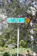 view gallery view gallerySW10.9 km |  Road to the future? Dead end - White Rock, NM Road to the future? Dead end - White Rock, NM
in Unintentionally Funny Signs Think you are travelling towards your future? Well, you hit a dead end. posted by: Hikenutty location: New Mexico date approved: 07/06/2010 last visited: 04/05/2019 |
|