 view gallery view gallery N4 km N4 km
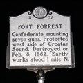
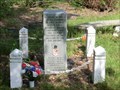
|   Fort Forrest, Marker B-52 Fort Forrest, Marker B-52
in North Carolina Historical Markers Confederate, mounting seven guns. Protected west side of Croatan Sound. Destroyed on Feb. 8, 1862. Earthworks stood 1 mile N. posted by:  drmellow drmellow location: North Carolina date approved: 11/07/2006 last visited: 08/08/2016 |
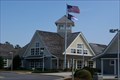
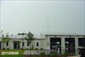
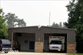 view gallery view galleryN5 km |  Dare County EMS - Station No. 8 - Manns Harbor, North Carolina Dare County EMS - Station No. 8 - Manns Harbor, North Carolina
in Paramedic Stations This Station of Dare County EMS is located at 6677 Highway 64 in Manns Harbor, Dare County, North Carolina. posted by:  outdoorboy34 outdoorboy34 location: North Carolina date approved: 09/24/2011 last visited: 09/10/2011 |
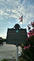
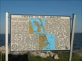 view gallery view galleryN6.9 km | Dare County: Gateway to the Albemarle --- Manns Harbor NC in North Carolina Historical Markers Located on US 64/264 at Umstead Memorial Bridge in Manns Harbor in
Dare, NC, US posted by: Countrydragon location: North Carolina date approved: 01/25/2010 last visited: never |
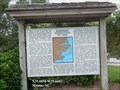
 view gallery view gallery NE8.2 km NE8.2 km
|  Commercial Fishing Heritage of Dare County Commercial Fishing Heritage of Dare County
in Maritime Monuments and Memorials Located at the rest area as you come into Dare County over Croatan Sound on the Virginia Dare Memorial Bridge. posted by: fatcat161 location: North Carolina date approved: 07/22/2009 last visited: 12/26/2023 |
 view gallery view galleryNE8.2 km |  Burnside Expedition of 1862 - Manteo NC Burnside Expedition of 1862 - Manteo NC
in Battlefields Much of coastal North Carolina fell to Union forces in 1862. Under Maj. Gen. Ambrose Burnside, a Rhode Islander, Union forces swept across the region, rolling up one victory after another. posted by: Don.Morfe location: North Carolina date approved: 04/21/2023 last visited: 12/26/2023 |
 view gallery view galleryNE8.2 km |  Burnside Expedition of 1862 - Manteo NC Burnside Expedition of 1862 - Manteo NC
in U.S. Civil War Sites Much of coastal North Carolina fell to Union forces in 1862.
Under Maj. Gen. Ambrose Burnside, a Rhode Islander, Union forces swept across the region, rolling up one victory after another. posted by: Don.Morfe location: North Carolina date approved: 10/09/2020 last visited: 10/01/2021 |
 view gallery view galleryNE8.2 km |  US-64 (ByP) - Roanoke Island, NC. US-64 (ByP) - Roanoke Island, NC.
in Blue Star Memorial Highway Markers A Blue Star Memorial Highway Marker at the Roanoke Island Visitor Center near Manteo, NC. posted by: Manville Possum location: North Carolina date approved: 08/13/2016 last visited: 12/30/2019 |
 view gallery view galleryNE8.2 km |  Roanoke Island Rest Area highway 64 Roanoke Island Rest Area highway 64
in Highway Rest Areas Roanoke Island Rest Area highway 64 posted by: kJfishman location: North Carolina date approved: 03/03/2009 last visited: 07/02/2016 |
 view gallery view galleryNE8.2 km |  Roanoke Island Visitor Center highway 64 Roanoke Island Visitor Center highway 64
in Tourist Information Centers - Visitor Centers Roanoke Island Visitor Center highway 64 posted by: kJfishman location: North Carolina date approved: 03/05/2009 last visited: 07/02/2016 |
 view gallery view galleryNE8.5 km |  Dare County Regional Airport Dare County Regional Airport
in Airports A small regional airport in Manteo on Roanoke Island, Outer Banks, NC. posted by: Gargoyle location: North Carolina date approved: 08/25/2005 last visited: never |
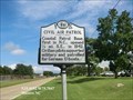 view gallery view galleryNE8.5 km | Civil Air Patrol (B-68) in North Carolina Historical Markers Coastal Patrol Base, first in N.C., opened ½ mi. S.E., in 1942. Civilian pilots supported military and patrolled for German U-boats. posted by: Don.Morfe location: North Carolina date approved: 03/26/2020 last visited: 10/23/2021 |
 view gallery view galleryNE8.5 km |  FIRST - Costal Patrol Base in NC.-Civil Air Patrol - Manteo NC FIRST - Costal Patrol Base in NC.-Civil Air Patrol - Manteo NC
in First of its Kind Civil Air Patrol-Coastal Patrol Base, first in N.C., opened ½ mi. S.E., in 1942. Civilian pilots supported military and patrolled for German U-boats. posted by: Don.Morfe location: North Carolina date approved: 10/21/2022 last visited: 10/22/2022 |
 view gallery view galleryNE8.5 km |  Former Slaves Burying Ground Memorial - Manteo NC Former Slaves Burying Ground Memorial - Manteo NC
in Civil Rights Memorials Memorial erected by the National Underground Railroad to Former Slaves buried within these grounds. posted by: Don.Morfe location: North Carolina date approved: 10/21/2022 last visited: 10/22/2022 |
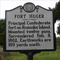 view gallery view galleryN8.9 km | Fort Huger, Marker B-2 in North Carolina Historical Markers Principal Confederate fort on Roanoke Island. Mounted twelve guns. Surrendered Feb. 8, 1862. Earthworks are 100 yards south. posted by: drmellow location: North Carolina date approved: 11/06/2006 last visited: 06/18/2013 |
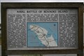 view gallery view galleryN8.9 km | Naval Battle of Roanoke Island, Marker BB-5 in North Carolina Historical Markers The naval battle of Roanoke Island took place on February 7, 1862. posted by: drmellow location: North Carolina date approved: 11/09/2006 last visited: 06/19/2013 |
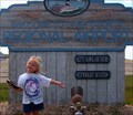
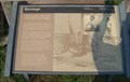 view gallery view galleryN8.9 km |  Bondage --- Near Manteo in Dare County, North Carolina Bondage --- Near Manteo in Dare County, North Carolina
in Signs of History Marker is near Manteo, North Carolina, in Dare County. Marker is on Freedman's Colony Road near U.S. 64/264, on the right when traveling west. Marker is located at a pull-off on the right just before the William B. Umstead Memorial Bridge. posted by: Countrydragon location: North Carolina date approved: 01/25/2010 last visited: 06/09/2008 |
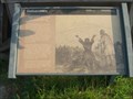 view gallery view galleryN8.9 km | Deliverance ---- Near Manteo in Dare County, North Carolina in Signs of History Marker is near Manteo, North Carolina, in Dare County. Marker is on Freedman's Colony Road near U.S. 64/264, on the right when traveling west posted by: Countrydragon location: North Carolina date approved: 01/25/2010 last visited: 06/09/2008 |
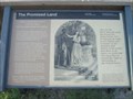 view gallery view galleryN8.9 km | The Promised Land -- Near Manteo in Dare County, North Carolina in Signs of History Marker is near Manteo, North Carolina, in Dare County. Marker is on Freedman's Colony Road near U.S. 64/264, on the right when traveling west.Marker is located at a pull-off on the right just before the William B. Umstead Memorial Bridge posted by: Countrydragon location: North Carolina date approved: 01/25/2010 last visited: 06/09/2008 |
 view gallery view galleryNE8.9 km | Dare County EMS - Station No. 2 - Manteo, North Carolina in Paramedic Stations This Station of Dare County EMS is located at 109 Exeter Street in Town of Manteo, Dare County, North Carolina. posted by: outdoorboy34 location: North Carolina date approved: 09/24/2011 last visited: 09/09/2011 |
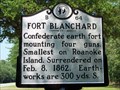 view gallery view galleryN9 km | Fort Blanchard | B-64 in North Carolina Historical Markers Located on US 64/264 boat access ramp at Croatan Sound bridge posted by: 3newsomes location: North Carolina date approved: 04/07/2009 last visited: 06/19/2013 |
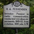 view gallery view galleryN9 km | R. A. Fessenden, Marker B-26 in North Carolina Historical Markers Inventor, Pioneer in radio communication, conducted wireless experiments, 1901-02, from a station, 600 yds. S.W. posted by: drmellow location: North Carolina date approved: 11/07/2006 last visited: 06/19/2013 |
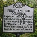
 view gallery view galleryN9 km | First English Colonies, Marker B-1 in North Carolina Historical Markers Explored in 1584. Site of first English settlements in new world, 1585-1587. Birthplace of Virginia Dare, first child born of English parents in America. posted by: drmellow location: North Carolina date approved: 11/06/2006 last visited: 06/19/2013 |
 view gallery view galleryN9 km | FIRST - English Settlements in New World - Roanoke Island, NC in First of its Kind Explored in 1584. Site of first English settlements in new world, 1585-1587. posted by: drmellow location: North Carolina date approved: 11/09/2006 last visited: 06/19/2013 |
 view gallery view galleryN9 km | FIRST - Child Born of English Parents In America (Virginia Dare) - Roanoke Island, NC in First of its Kind Roanoke Island: Birthplace of Virginia Dare, first child born of English parents in America. posted by: drmellow location: North Carolina date approved: 11/09/2006 last visited: 06/19/2013 |
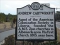 view gallery view galleryNE9 km | B-44 Andrew Cartwright in North Carolina Historical Markers Agent of the American Colonization Society in Liberia, founded the A.M.E. Zion churches in Albemarle area. His first church, 1865, near here. posted by: Edgar Allan Gump location: North Carolina date approved: 02/21/2007 last visited: 12/01/2003 |
|