 view gallery view gallery N0.3 km N0.3 km
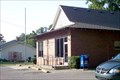
|   Wanchese, NC 27981 Wanchese, NC 27981
in U.S. Post Offices Located at 3525 Mill Landing Rd. posted by:  LJParr LJParr location: North Carolina date approved: 08/25/2010 last visited: never |
 view gallery view gallery NW5.5 km NW5.5 km
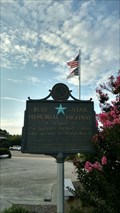
|  US-64 (ByP) - Roanoke Island, NC. US-64 (ByP) - Roanoke Island, NC.
in Blue Star Memorial Highway Markers A Blue Star Memorial Highway Marker at the Roanoke Island Visitor Center near Manteo, NC. posted by:  Manville Possum Manville Possum location: North Carolina date approved: 08/13/2016 last visited: 12/30/2019 |
 view gallery view galleryNW5.5 km |  Burnside Expedition of 1862 - Manteo NC Burnside Expedition of 1862 - Manteo NC
in U.S. Civil War Sites Much of coastal North Carolina fell to Union forces in 1862.
Under Maj. Gen. Ambrose Burnside, a Rhode Islander, Union forces swept across the region, rolling up one victory after another. posted by: Don.Morfe location: North Carolina date approved: 10/09/2020 last visited: 10/01/2021 |
 view gallery view galleryNW5.5 km |  Burnside Expedition of 1862 - Manteo NC Burnside Expedition of 1862 - Manteo NC
in Battlefields Much of coastal North Carolina fell to Union forces in 1862. Under Maj. Gen. Ambrose Burnside, a Rhode Islander, Union forces swept across the region, rolling up one victory after another. posted by: Don.Morfe location: North Carolina date approved: 04/21/2023 last visited: 12/26/2023 |
 view gallery view galleryN5.5 km |  Battle of Roanoke Island, Marker BB-4 Battle of Roanoke Island, Marker BB-4
in North Carolina Historical Markers The US Civil War Battle of Roanoke Island on February 7, 1862. posted by: drmellow location: North Carolina date approved: 11/09/2006 last visited: 09/24/2012 |
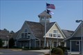 view gallery view galleryNW5.5 km |  Roanoke Island Visitor Center highway 64 Roanoke Island Visitor Center highway 64
in Tourist Information Centers - Visitor Centers Roanoke Island Visitor Center highway 64 posted by: kJfishman location: North Carolina date approved: 03/05/2009 last visited: 07/02/2016 |
 view gallery view galleryNW5.5 km |  Roanoke Island Rest Area highway 64 Roanoke Island Rest Area highway 64
in Highway Rest Areas Roanoke Island Rest Area highway 64 posted by: kJfishman location: North Carolina date approved: 03/03/2009 last visited: 07/02/2016 |
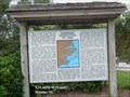
 view gallery view galleryNW5.5 km |  Commercial Fishing Heritage of Dare County Commercial Fishing Heritage of Dare County
in Maritime Monuments and Memorials Located at the rest area as you come into Dare County over Croatan Sound on the Virginia Dare Memorial Bridge. posted by: fatcat161 location: North Carolina date approved: 07/22/2009 last visited: 12/26/2023 |
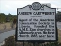 view gallery view galleryN5.6 km | B-44 Andrew Cartwright in North Carolina Historical Markers Agent of the American Colonization Society in Liberia, founded the A.M.E. Zion churches in Albemarle area. His first church, 1865, near here. posted by: Edgar Allan Gump location: North Carolina date approved: 02/21/2007 last visited: 12/01/2003 |
 view gallery view gallery E6.3 km E6.3 km
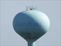
|  Water Tower - Nags Head NC Water Tower - Nags Head NC
in Water Towers The Water Tower is just off the Old Oregon Inlet Road about 3.4 miles south of the junction of US Hwy 64 & 158 in Nags Head on North Carolina's Outer Banks. posted by: PeterNoG location: North Carolina date approved: 04/02/2012 last visited: 06/07/2013 |
 view gallery view gallery NE6.4 km NE6.4 km
|  NC 12 45 - Dare County, NC NC 12 45 - Dare County, NC
in U.S. Benchmarks A stainless steel rod on NC 12 in Dare Co, NC. posted by: LJParr location: North Carolina date approved: 08/27/2010 last visited: never |
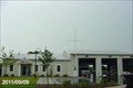
 view gallery view galleryNE6.8 km |  South Nags Head Fire Station South Nags Head Fire Station
in Firehouses The South Nags Head Fire Station is located at 8806 Old Oregon Inlet Road in the Town of Nags Head, Dare County, North Carolina posted by: outdoorboy34 location: North Carolina date approved: 09/25/2011 last visited: 09/07/2011 |
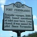 view gallery view galleryE6.9 km | Port Ferdinando, Marker B-60 in North Carolina Historical Markers An inlet near this marker was the base of operations for the Roanoke voyages from 1585 to 1590. Port Ferdinando was named in honor of the ship's pilot, who discovered it. posted by: showbizkid location: North Carolina date approved: 06/26/2006 last visited: 07/05/2016 |
 view gallery view galleryE7.2 km |  Bodie Island Lighthouse Bodie Island Lighthouse
in NPS Passport Cancellation Stations Bodie Island Lighthouse at Cape Hatteras National Seashore. posted by: GwynEvie location: North Carolina date approved: 02/02/2009 last visited: 12/09/2022 |
 view gallery view galleryE7.2 km |  Bodie Island Lighthouse - Nags Head, NC Bodie Island Lighthouse - Nags Head, NC
in Lighthouse Passport Stamps Bodie Island Lighthouse at Cape Hatteras National Seashore. posted by: fatcat161 location: North Carolina date approved: 07/07/2010 last visited: 07/02/2016 |
 view gallery view galleryE7.2 km |  Coquina Beach Wind Turbine Coquina Beach Wind Turbine
in Windmills Located off Hwy 12 near the entrance to Bodie Lighthouse. posted by: fatcat161 location: North Carolina date approved: 05/20/2009 last visited: 01/18/2010 |
 view gallery view galleryNW7.2 km |  Dare County EMS - Station No. 2 - Manteo, North Carolina Dare County EMS - Station No. 2 - Manteo, North Carolina
in Paramedic Stations This Station of Dare County EMS is located at 109 Exeter Street in Town of Manteo, Dare County, North Carolina. posted by: outdoorboy34 location: North Carolina date approved: 09/24/2011 last visited: 09/09/2011 |
 view gallery view galleryE7.2 km |  Brodie Island Lighthouse - Nags Head NC Brodie Island Lighthouse - Nags Head NC
in Satellite Imagery Oddities The current Bodie Island Lighthouse is the third that has stood in this vicinity of Bodie Island on the Outer Banks in North Carolina. It is part of the Cape Hatteras National Seashore. posted by: Don.Morfe location: North Carolina date approved: 09/26/2022 last visited: 09/27/2022 |
 view gallery view galleryE7.2 km | 865 2537 TIDAL 4 at Bodie Island Lighthouse - EX0144 in U.S. Benchmarks Located at the base of the Bodie Island Lighthouse - Restricted access; do not enter the fenced in area! posted by: CoinsAndPins location: North Carolina date approved: 03/13/2008 last visited: 07/23/2021 |
 view gallery view galleryE7.2 km | BODIE ISLAND LIGHTHOUSE 1875 - PID EX0475 in U.S. Benchmarks A wonderful lighthouse with easy access on the Outer Banks of North Carolina. posted by: CoinsAndPins location: North Carolina date approved: 03/13/2008 last visited: 09/27/2022 |
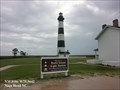 view gallery view galleryE7.2 km |  Bodie Island Lighthouse - Nags Head NC Bodie Island Lighthouse - Nags Head NC
in Wikipedia Entries The current Bodie Island Lighthouse is the third that has stood in this vicinity of Bodie Island on the Outer Banks in North Carolina and was built in 1872. posted by: Don.Morfe location: North Carolina date approved: 12/08/2022 last visited: 12/09/2022 |
 view gallery view galleryE7.2 km |  Bodie Island Light Station Bodie Island Light Station
in U.S. National Register of Historic Places The Bodie Island Light Station was listed on the National Register in 2003. The Light Station is the the third on the site. The first was poorly constructed and the second destroyed by the Confederates during the Civil War. The present lighthouse was built in 1872. It is now operated by the National Parks Service. posted by: showbizkid location: North Carolina date approved: 07/01/2006 last visited: 05/14/2023 |
 view gallery view galleryE7.2 km |  Bodie Island Lighthouse, North Carolina Bodie Island Lighthouse, North Carolina
in Coastal Lighthouses Bodie Island Light Station is operated by the National Parks Service, having taken over for the Coast Guard a few years ago. The present lighthouse is the third on the site. The first was poorly constructed and the second destroyed by the Confederates during the Civil War. The present lighthouse was built in 1872. posted by: showbizkid location: North Carolina date approved: 06/26/2006 last visited: 05/14/2023 |
 E7.4 km |  Laura A. Barnes Laura A. Barnes
in Shipwrecks A four-masted Schooner that wrecked in 1921 in the Outer Banks. posted by: Drakkenfyre location: North Carolina date approved: 06/18/2006 last visited: 06/28/2006 |
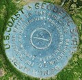
 view gallery view galleryE7.4 km | B 169 - Dare County, NC in U.S. Benchmarks A benchmark disk located on NC 12 at the entrance to Bodie Island Lighthouse. posted by: LJParr location: North Carolina date approved: 08/29/2010 last visited: 08/09/2016 |
|