 view gallery view gallery NE2.3 km NE2.3 km
|   Little Switzerland, NC 28749 Little Switzerland, NC 28749
in U.S. Post Offices The post office in Little Switzerland, NC posted by:  chrissyml chrissyml location: North Carolina date approved: 07/25/2024 last visited: never |
 view gallery view galleryNE2.3 km |  Little Switzerland, NC - Population 46 Little Switzerland, NC - Population 46
in Population Signs The population of a very small town! posted by: chrissyml location: North Carolina date approved: 08/07/2024 last visited: never |
 view gallery view galleryNE2.3 km |  Little Switzerland Post Office - Little Switzerland, NC Little Switzerland Post Office - Little Switzerland, NC
in Painted Barn Quilts A barn square on a tiny town post office posted by: chrissyml location: North Carolina date approved: 07/24/2024 last visited: never |
 view gallery view galleryNE2.6 km |  The Church of the Resurrection - Little Switzerland, NC, USA The Church of the Resurrection - Little Switzerland, NC, USA
in Anglican and Episcopal Churches An Episcopal Summer Chapel, built in 1913. Services are held each Sunday, May through October. posted by:  PFF PFF location: North Carolina date approved: 01/09/2010 last visited: 10/05/2023 |
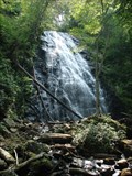 view gallery view gallery SW3.7 km SW3.7 km
|  "Crabtree Falls" - Blue Ridge Parkway, North Carolina "Crabtree Falls" - Blue Ridge Parkway, North Carolina
in Waterfalls A wonderful stop at mile marker 339.5 along the Blue Ridge Parkway. posted by: BarbershopDru location: North Carolina date approved: 07/22/2010 last visited: never |
 view gallery view gallery E6 km E6 km
|  BRP and NC 226 Eastern Continental Divide BRP and NC 226 Eastern Continental Divide
in Elevation Signs This is a waymark along one of my favorite motorways. posted by: NCDaywalker location: North Carolina date approved: 06/19/2014 last visited: 06/10/2018 |
 view gallery view galleryE6 km |  Spruce Mine Mining District | N-45 Spruce Mine Mining District | N-45
in North Carolina Historical Markers Located on NC 226 at Blue Ridge Parkway southeast of Spruce Pine posted by: 3newsomes location: North Carolina date approved: 12/31/2011 last visited: 06/10/2018 |
 NE7.2 km |  Walmart -- Spruce Pine, NC Walmart -- Spruce Pine, NC
in WAL*MART Stores The Spruce Pine, NC Walmart. posted by: papermanone & catlover location: North Carolina date approved: 01/02/2007 last visited: 06/10/2018 |
 view gallery view galleryNE7.2 km |  Subway in Walmart -- Spruce Pine, NC Subway in Walmart -- Spruce Pine, NC
in Subway Restaurants One of many Spruce Pine Subway's. posted by: papermanone & catlover location: North Carolina date approved: 01/02/2007 last visited: never |
 view gallery view galleryNE8.2 km |  Spruce Pine Cemetery Spruce Pine Cemetery
in Worldwide Cemeteries Graves, plus a Benchmark, in a beautiful location in the North Carolina mountains. posted by: PFF location: North Carolina date approved: 05/29/2007 last visited: never |
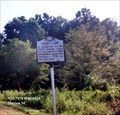 view gallery view gallery SE8.4 km SE8.4 km
| Cathey's Fort (N-26) in North Carolina Historical Markers A rendezvous for the North Carolina militia led by General Griffith Rutherford against the Cherokee in 1776, was one mile east. posted by: Don.Morfe location: North Carolina date approved: 04/02/2020 last visited: 10/23/2021 |
 view gallery view galleryNE9.7 km |  CSX Freight Depot, Spruce Pine, NC CSX Freight Depot, Spruce Pine, NC
in Train Stations/Depots Wood-Stucco depot, built in 1909 to serve Mitchell County, NC. posted by: PFF location: North Carolina date approved: 05/26/2007 last visited: 07/24/2024 |
 view gallery view galleryE10.8 km |  AE9917 - Travenol AE9917 - Travenol
in U.S. Benchmarks Easily locatable and in very good condition. On private property – Baxter Corporation. You will need permission to enter the grounds posted by: Beagle-1 location: North Carolina date approved: 04/21/2008 last visited: never |
 view gallery view gallery S12.9 km S12.9 km
|  Lake Tahoma Dam, North Carolina Lake Tahoma Dam, North Carolina
in Water Dams Located near highway 80. Little Buck Creek Rd crosses over the dam. posted by: CoinsAndPins location: North Carolina date approved: 10/08/2007 last visited: 06/16/2014 |
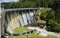 view gallery view galleryS12.9 km |  Lake Tahoma Dam Lake Tahoma Dam
in Ghosts and Hauntings Located near highway 80 on Little Buck Creek Rd. posted by: CoinsAndPins location: North Carolina date approved: 10/08/2007 last visited: 06/13/2008 |
 view gallery view gallerySW15 km |  Laurel Knob Overlook - Old Fort, NC Laurel Knob Overlook - Old Fort, NC
in Scenic Roadside Look-Outs One of many scenic overlooks on the Blue Ridge Parkway. posted by: chrissyml location: North Carolina date approved: 08/12/2024 last visited: never |
 view gallery view gallerySW15 km | Laurel Knob Overlook - 4602 feet - Laurel Springs, NC in Elevation Signs One of many scenic overlooks on the Blue Ridge Parkway posted by: chrissyml location: North Carolina date approved: 08/07/2024 last visited: never |
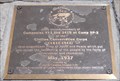 view gallery view gallerySW15.8 km |  Camp SP-2 of the CCC, Mount Mitchell, North Carolina Camp SP-2 of the CCC, Mount Mitchell, North Carolina
in Civilian Conservation Corps A monument to the members of Companies 413 and 2410 at Camp SP-2 of the Civilian Conservation Corps located near the summit of Mount Mitchell, North Carolina. posted by: PersonsMD location: North Carolina date approved: 05/30/2011 last visited: 08/27/2018 |
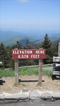 view gallery view gallerySW15.8 km | Mount Mitchell Parking Lot, 6,578 Feet Mt. Mitchell, North Carolina in Elevation Signs A sign posting the elevation of the parking lot found near the summit of Mount Mitchell in North Carolina. Mount Mitchell is the highest peak in the United States found East of the Mississippi River. posted by: PersonsMD location: North Carolina date approved: 05/24/2011 last visited: 05/24/2017 |
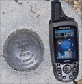 view gallery view gallerySW15.8 km | Black Bear 2008 in U.S. Benchmarks The Black Beark Horizontal Control Mark can be found in the upper parking lot at the Mount Mitchell visitor center. posted by: PersonsMD location: North Carolina date approved: 05/26/2011 last visited: 08/27/2018 |
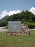 view gallery view gallerySW15.8 km |  Mount Mitchell State Park - Burnsville, North Carolina Mount Mitchell State Park - Burnsville, North Carolina
in State/Provincial Parks The tallest mountain peak East of the Mississippi River is Mt. Mitchell, in North Carolina. posted by: BarbershopDru location: North Carolina date approved: 07/22/2010 last visited: 10/04/2023 |
 view gallery view gallerySW15.8 km |  Mount Mitchell State Park - Mount Mitchell, North Carolina Mount Mitchell State Park - Mount Mitchell, North Carolina
in U.S. National Natural Landmarks Located just off of the Famous Blue Ridge Parkway, Mount Mitchell State Park provides visitors with breathtaking views of the Blue Ridge Mountains; historical insight into early American heritage and ample opportunities to commune with nature. posted by: PersonsMD location: North Carolina date approved: 05/24/2011 last visited: 10/04/2023 |
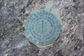 view gallery view gallerySW15.8 km | Mt. Mitchell, NC Geodetic in U.S. Benchmarks Geodetic Survey Benchmark found on the Basalm Nature Trail Near the Peak of Mount Mitchell, NC. posted by: JensenFamily05 location: North Carolina date approved: 10/23/2010 last visited: 08/12/2011 |
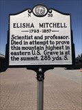 view gallery view gallerySW15.8 km | Elisha Mitchell N-38 in North Carolina Historical Markers Located in the parking lot on top of Mount Mitchell. posted by: flyingmoose location: North Carolina date approved: 03/05/2023 last visited: 10/05/2023 |
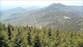
 view gallery view gallerySW15.8 km |  Mt. Mitchell Mt. Mitchell
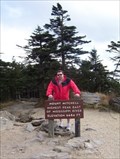
in Mountain Summits Mt. Mitchell, the highest peak east of the Mississippi River, is named for Dr. Elisha Mitchell, a professor of sciences at UNC-Chapel Hill who first suggested that the peak that bears his name was the highest in the Black Mountain range. Dr. Mitchell died at a waterfall on the western slope of the mountain while returning from one of many exploratory trips to western North Carolina. posted by: ScubaDewd location: North Carolina date approved: 04/03/2006 last visited: 10/04/2023 |
|