 view gallery view gallery N4.7 km N4.7 km
|   McDonalds - I-40 - Old Fort, NC McDonalds - I-40 - Old Fort, NC
in McDonald's Restaurants This McDonalds is at I-40 Exit 73 in Old Fort, NC. posted by:  papermanone & catlover papermanone & catlover location: North Carolina date approved: 05/04/2007 last visited: 02/10/2021 |
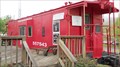
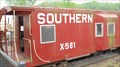 view gallery view galleryN5.5 km |  Southern Railway X-581 Bay Window Caboose, Old Fort, North Carolina Southern Railway X-581 Bay Window Caboose, Old Fort, North Carolina
in Train Cabooses This Southern Railway Steel Bay Window Caboose is open to the public and is located at the old Old Fort, NC., train station. Both the caboose and the train station serve as a visitor ceneter and museum. posted by: PersonsMD location: North Carolina date approved: 05/13/2011 last visited: 08/29/2022 |
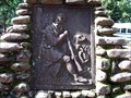
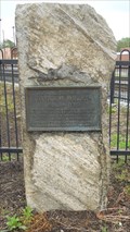 view gallery view galleryN5.5 km |  James W. Wilson, Old Fort, North Carolina James W. Wilson, Old Fort, North Carolina
in Citizen Memorials This marker honors the contributions made to Western North Carolina by Civil Engineer, James W. Wilson. posted by: PersonsMD location: North Carolina date approved: 05/14/2011 last visited: 08/29/2022 |
 view gallery view galleryN5.5 km |  N~31 Frontier Fort N~31 Frontier Fort
in North Carolina Historical Markers Located in Old Fort, North Carolina this marker notes the early fortification and military presence of this Frontier Fort. posted by: PersonsMD location: North Carolina date approved: 05/19/2011 last visited: 08/29/2022 |
 view gallery view galleryN5.5 km |  Boone Trail Marker #30 - Old Fort, NC Boone Trail Marker #30 - Old Fort, NC
in Daniel Boone Trail Markers Boone Trail Marker #30 located in Old Fort, North Carolina. posted by:  david28377 david28377 location: North Carolina date approved: 10/22/2013 last visited: 08/29/2022 |
 view gallery view galleryN5.5 km |  Old Fort Depot (1881), Old Fort, North Carolina Old Fort Depot (1881), Old Fort, North Carolina
in Train Stations/Depots Built in 1881, the Old Fort train depot has been beautifully restored to capture a period long gone by. This depot is located in historic Old Fort, North Carolina. Now serves as the town Visitor Center, Chamber of Commerce and train history museum. posted by: PersonsMD location: North Carolina date approved: 05/13/2011 last visited: 08/29/2022 |
 view gallery view gallery NW6.8 km NW6.8 km
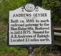
| N~37 Andrews Geyser in North Carolina Historical Markers This marker notes the historic geyser that was built in 1879 by the railroad, Andrews Geyser posted by: PersonsMD location: North Carolina date approved: 05/19/2011 last visited: 08/29/2022 |
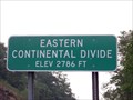 view gallery view galleryNW7.9 km |  Eastern Continental Divide Eastern Continental Divide
in Elevation Signs I-40 near Black Mountain, NC posted by: Padon location: North Carolina date approved: 07/21/2008 last visited: 08/22/2013 |
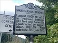 view gallery view galleryNW8.7 km | Swannanoa Tunnel P-46 in North Carolina Historical Markers Located at Yates Avenue and Royal Gorge Road, Black Mountain posted by: Markerman62 location: North Carolina date approved: 09/29/2022 last visited: never |
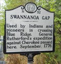 view gallery view galleryNW8.9 km | N~32 Swannanoa Gap in North Carolina Historical Markers Located between Old Fort and Black Mountain, North Carolina, this marker notes a major transportation route used by early people to cross the Blue Ridge Mountains and the associated history of the area. posted by: PersonsMD location: North Carolina date approved: 05/19/2011 last visited: 08/29/2022 |
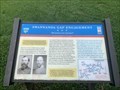 view gallery view galleryNW8.9 km |  Swannanoa Gap Engagement - "Blockaded and defended" - Ridgecrest, NC Swannanoa Gap Engagement - "Blockaded and defended" - Ridgecrest, NC
in Civil War Discovery Trail Sites Located on North Yates Avenue between Ridgecrest Drive and Old U.S. 70, Ridgecrest posted by: Markerman62 location: North Carolina date approved: 09/29/2022 last visited: never |
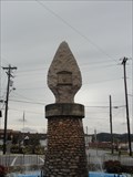
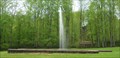
 view gallery view galleryNW9.2 km |  Andrews Geyser, Old Fort, North Carolina Andrews Geyser, Old Fort, North Carolina
in Fountains This manmade geyser was built in 1885 as a memorial to the workers who gave their lives to build the railroad between Old Fort and Asheville became a major tourist attraction in the area. It shoots water continuously to a height of 80 feet. posted by: PersonsMD location: North Carolina date approved: 05/14/2011 last visited: 08/29/2022 |
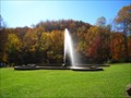
 view gallery view galleryNW9.2 km |  Andrews Geyser, Old Fort, North Carolina Andrews Geyser, Old Fort, North Carolina
in Wikipedia Entries This manmade geyser was built in 1885 as a memorial to the workers who gave their lives to build the railroad between Old Fort and Asheville became a major tourist attraction in the area. It shoots water continuously to a height of 80 feet. posted by: PersonsMD location: North Carolina date approved: 05/21/2011 last visited: 08/30/2022 |
 view gallery view galleryNW9.2 km | Swannanoa Gap Engagement - Old Fort, NC in Civil War Discovery Trail Sites Trails sign located at Andrews Geyser Park describes engangement on April 20 and 21, 1865 in which confederates effectually blocked and defended this mountain passage from Stoneman's raiders en route to Asheville, NC. posted by: geodave88 location: North Carolina date approved: 11/24/2008 last visited: 08/30/2022 |
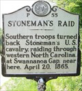 view gallery view galleryNW9.3 km | P 55 Stoneman's Raid in North Carolina Historical Markers Southern troops turned Stoneman's cavalry back near Black Mtn. NC 1865. posted by: Padon location: North Carolina date approved: 05/09/2011 last visited: 08/29/2022 |
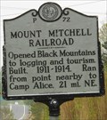 view gallery view galleryNW10.9 km | P~72 Mount Mitchell Railroad in North Carolina Historical Markers Located in Black Mountain, North Carolina, this marker notes the historic Mitchell Railroad that began a period of tourism and logging in the area. posted by: PersonsMD location: North Carolina date approved: 05/19/2011 last visited: 08/29/2022 |
 view gallery view gallery S10.9 km S10.9 km
|  Eagle Rock Eagle Rock
in Mountain Bike Trailheads Located along State Road. posted by: flyingmoose location: North Carolina date approved: 04/21/2023 last visited: never |
 view gallery view galleryS10.9 km |  Buffalo Creek and Eagle Rock - Lake Lure, North Carolina Buffalo Creek and Eagle Rock - Lake Lure, North Carolina
in Hiking and walking trailheads Located along State Road. posted by: flyingmoose location: North Carolina date approved: 03/16/2023 last visited: never |
 view gallery view gallery W12.1 km W12.1 km
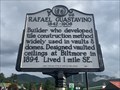
| Rafael Guastavino 1842-1908 P-98 in North Carolina Historical Markers Located on NC 9 at the I-40 exit ramp, Black Mountain posted by: Markerman62 location: North Carolina date approved: 09/30/2022 last visited: never |
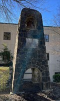 view gallery view galleryNW12.2 km |  Graham Chapel Bell - Black Mountain, North Carolina Graham Chapel Bell - Black Mountain, North Carolina
in Bell Towers A church bell located in Black Mountain, North Carolina. posted by: dream chaser location: North Carolina date approved: 04/06/2022 last visited: never |
 view gallery view galleryNW12.4 km | Daniel Boone Marker # 68 - Montreat, NC in Daniel Boone Trail Markers Daniel Boone Trail marker in a rock pyramid that was the base of an old flag pole. Parking lot of Anderson Auditorium, Montreat Conference Center grounds, Montreat, NC. Date placed approximately February 22, 1930. posted by: stanje1 location: North Carolina date approved: 01/16/2011 last visited: 08/29/2022 |
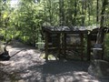
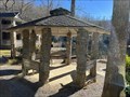 view gallery view galleryNW12.4 km |  Lake Susan Gazebo - Montreat, North Carolina Lake Susan Gazebo - Montreat, North Carolina
in Gazebos A gazebo located in Montreat, North Carolina. posted by: dream chaser location: North Carolina date approved: 12/17/2021 last visited: never |
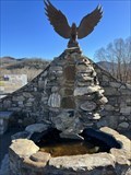 view gallery view galleryW12.4 km | Grey Eagle Fountain - Black Mountain, North Carolina in Fountains A fountain located in Black Mountain, North Carolina. posted by: dream chaser location: North Carolina date approved: 12/22/2021 last visited: never |
 view gallery view galleryW12.4 km | Norfolk and Western 557543 Bay Window Caboose, Black Mountain, North Carolina in Train Cabooses This Class C-6P Norfolk and Western Bay Window Caboose is located in Black Mountain, North Carolina and now serves as a museum featuring images of the local area and train history. posted by: PersonsMD location: North Carolina date approved: 05/17/2011 last visited: 04/22/2011 |
 view gallery view galleryW12.4 km |  Sassafrass Little Free Library #94581 - Black Mountain, North Carolina Sassafrass Little Free Library #94581 - Black Mountain, North Carolina
in Free Community Book Exchanges A Little Free Library in Black Mountain, North Carolina. posted by: dream chaser location: North Carolina date approved: 12/14/2021 last visited: never |
|