 view gallery view gallery SE9.3 km SE9.3 km
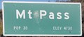
|   Mountain Pass, California - Interstate 15 Northbound - Elevation 4730 feet Mountain Pass, California - Interstate 15 Northbound - Elevation 4730 feet
in Elevation Signs This is the last summit as you travel Interstate 15 from California to Nevada. From here it's downhill all the way. posted by:  brwhiz brwhiz location: California date approved: 03/18/2011 last visited: 03/30/2012 |
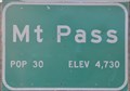
 view gallery view gallerySE9.3 km |  Mountain Pass, California ~ Population 30 Mountain Pass, California ~ Population 30
in Population Signs This is the last summit as you travel Interstate 15 from California to Nevada. posted by: brwhiz location: California date approved: 03/18/2011 last visited: 03/08/2016 |
 view gallery view gallerySE9.3 km |  Mountain Pass, California Mountain Pass, California
in Wikipedia Entries Mountain Pass has what is probably the smallest population of any recognized entity in the state of California. posted by: brwhiz location: California date approved: 03/26/2011 last visited: 03/08/2016 |
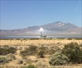
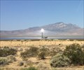 view gallery view gallery E10.1 km E10.1 km
| Ivanpah Solar Power Plant - Ivanpah, CA in Wikipedia Entries A large, blinding, solar array can be seen while passing by on Interstate 15. posted by: bluesnote location: California date approved: 12/07/2016 last visited: 12/07/2016 |
 view gallery view galleryE10.1 km |  MOST -- Powerful Solar Thermal Power Plant - Ivanpah, CA MOST -- Powerful Solar Thermal Power Plant - Ivanpah, CA
in Guinness World Records A large, blinding, solar array can be seen while passing by on Interstate 15. posted by: bluesnote location: California date approved: 09/22/2017 last visited: 09/22/2017 |
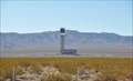 view gallery view galleryE10.1 km |  Ivanpah Solar Project Ivanpah Solar Project
in Solar Power This Solar Power generation plant, currently the world's largest such plant under construction, is situated just a few miles from Primm on the California, Nevada border. posted by: brwhiz location: California date approved: 08/23/2013 last visited: 10/31/2017 |
 view gallery view galleryE10.1 km |  MOST -- Powerfull Solar Thermal Power Plant - Ivanpah, CA MOST -- Powerfull Solar Thermal Power Plant - Ivanpah, CA
in Superlatives A large, blinding, solar array can be seen while passing by on Interstate 15. posted by: bluesnote location: California date approved: 09/23/2017 last visited: 09/23/2017 |
 view gallery view galleryE10.1 km |  Ivanpah Solar Power Plant - Ivanpah, CA Ivanpah Solar Power Plant - Ivanpah, CA
in Satellite Imagery Oddities A large, blinding, solar array can be seen while passing by on Interstate 15. posted by: bluesnote location: California date approved: 12/02/2016 last visited: 12/02/2016 |
 view gallery view gallerySE10.5 km | Mountain Pass, California - Interstate 15 Southbound - Elevation 4730 feet in Elevation Signs Mountain Pass is a very small town with a very big mine. posted by: brwhiz location: California date approved: 03/15/2012 last visited: 03/08/2016 |
 view gallery view gallerySE10.5 km | Mountain Pass, California ~ Population 30 in Population Signs Mountain Pass is so small and so high its altitude is almost 160 times its population. posted by: brwhiz location: California date approved: 03/15/2012 last visited: 03/08/2016 |
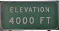 view gallery view gallery SW10.6 km SW10.6 km
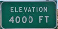
| Mountain Pass, South Grade ~ Interstate 15 Southbound - Elevation 4000 feet in Elevation Signs Passing down through 4000 feet heading into the saddle between Mountain Pass and Halloran Springs. posted by: brwhiz location: California date approved: 03/15/2012 last visited: 03/08/2016 |
 view gallery view gallerySW10.6 km | Mountain Pass, South Grade ~ Interstate 15 Northbound - Elevation 4000 feet in Elevation Signs Passing up through the 4000 foot level leaving the saddle and climbing toward Mountain Pass. posted by: brwhiz location: California date approved: 03/18/2011 last visited: 03/30/2012 |
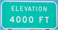
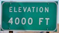 view gallery view gallerySE13 km | Mountain Pass, North Grade ~ Interstate 15 Northbound - Elevation 4000 feet in Elevation Signs Passing down through the 4000 level on the way into Nevada. posted by: brwhiz location: California date approved: 03/18/2011 last visited: 03/30/2012 |
 view gallery view gallerySE13 km | Mountain Pass, North Grade ~ Interstate 15 Southbound - Elevation 4000 feet in Elevation Signs Passing upward through 4000 feet just below Mountain Pass, California. posted by: brwhiz location: California date approved: 03/15/2012 last visited: 03/08/2016 |
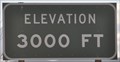 view gallery view gallerySE14 km | Mountain Pass, North Grade ~ Interstate 15 Southbound - Elevation 3000 feet in Elevation Signs You are passing upward through 3000 feet on your way to Mountain Pass. posted by: brwhiz location: California date approved: 03/15/2012 last visited: 05/24/2016 |
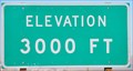 view gallery view gallerySE14.2 km | Mountain Pass, North Grade - Interstate 15 Northbound - Elevation 3000 feet in Elevation Signs Dropping through 3000 feet on the long straight stretch to the desert floor and the casinos at Primm. posted by: brwhiz location: California date approved: 03/18/2011 last visited: 03/08/2016 |
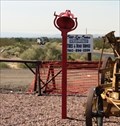 view gallery view gallerySW14.2 km |  Red Bell - Nipton, CA Red Bell - Nipton, CA
in Bells A red bell on a pole can be seen at a Shell gas station in Nipton, off of Interstate 15. posted by: bluesnote location: California date approved: 10/22/2016 last visited: 10/22/2016 |
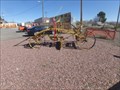 view gallery view gallerySW14.2 km |  1890's Austin Steel Reversible Road Machine - I-15/Cima Rd, CA 1890's Austin Steel Reversible Road Machine - I-15/Cima Rd, CA
in Preserved Machines on Public Display Preserved late 19th-century road grader on display at a service station on I15. posted by: jiggs11 location: California date approved: 03/27/2016 last visited: never |
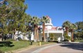 view gallery view galleryE14.3 km |  Primm Valley Lakes Course Primm Valley Lakes Course
in Public and Private Golf Courses This Golf Course is located at 1 Yates Well Road, Nipton, California. posted by: brwhiz location: California date approved: 08/26/2013 last visited: 03/03/2014 |
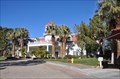 view gallery view galleryE14.5 km | Primm Valley Desert Course in Public and Private Golf Courses This Golf Course is located at 1 Yates Well Road, Nipton, California. posted by: brwhiz location: California date approved: 08/26/2013 last visited: 03/03/2014 |
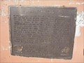 view gallery view gallerySW16.1 km |  Valley Wells - Baker, CA Valley Wells - Baker, CA
in California Historical Markers Located at the Valley Wells wetbound rest area. posted by: ChapterhouseInc location: California date approved: 02/23/2011 last visited: 02/08/2019 |
 view gallery view gallerySW16.1 km |  Valley Wells - Baker, CA Valley Wells - Baker, CA
in E Clampus Vitus Historical Markers Located at the Valley Wells wetbound rest area. posted by: ChapterhouseInc location: California date approved: 02/08/2011 last visited: 04/11/2015 |
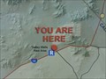 view gallery view gallerySW16.1 km |  You Are Here - Valley Wells Rest Area W/B I-15 near Baker, CA You Are Here - Valley Wells Rest Area W/B I-15 near Baker, CA
in 'You Are Here' Maps You Are Here graphic of the Mojave Desert, centered on the Valley Wells Rest Stop. posted by: jiggs11 location: California date approved: 03/28/2016 last visited: 02/08/2019 |
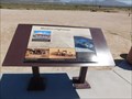 view gallery view gallerySW16.1 km |  Modern Highways - Baker, CA Modern Highways - Baker, CA
in Signs of History One of many plaques at a rest area along Interstate 15. posted by: bluesnote location: California date approved: 03/29/2016 last visited: 03/29/2016 |
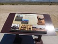 view gallery view gallerySW16.1 km | Railroads Revolutionize Transportation - Baker, CA in Signs of History One of many plaques at a rest area along Interstate 15. posted by: bluesnote location: California date approved: 03/29/2016 last visited: 03/29/2016 |
|