 view gallery view gallery S8.4 km S8.4 km
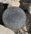
|   US DOI/BLM Castadral Survey Marker TR 37 AP 4 -- Mojave Cross, nr Cima CA US DOI/BLM Castadral Survey Marker TR 37 AP 4 -- Mojave Cross, nr Cima CA
in U.S. Benchmarks A US DOI/BLM Castadral Survey Marker T at the boundary between government land and VFW land at the Mojave Cross, nr Cima CA posted by:  Benchmark Blasterz Benchmark Blasterz location: California date approved: 04/01/2016 last visited: 03/08/2016 |
 view gallery view galleryS8.4 km |  "Mojave Cross found in Half-Moon Bay" -- Mojave National Preserve, nr Cima CA "Mojave Cross found in Half-Moon Bay" -- Mojave National Preserve, nr Cima CA
in News Article Locations A local newspaper article details the fraught history of the Mojave Cross on Sunrise Mountain in the remote Mojave Desert near Cima CA posted by: Benchmark Blasterz location: California date approved: 04/01/2016 last visited: 03/08/2016 |
 view gallery view galleryS8.4 km |  The Mojave Cross -- Mojave National Preserve, nr Cima CA The Mojave Cross -- Mojave National Preserve, nr Cima CA
in Non-Specific Veteran Memorials The Mojave Cross was first erected in 1934 to honor all dead of all wars. In the intervening years, it has had a lot of controversy stirred up around it, been covered up, stolen, recovered, and replaced. posted by: Benchmark Blasterz location: California date approved: 04/01/2016 last visited: 03/08/2016 |
 view gallery view galleryS8.4 km |  The Mojave Cross -- Mojave National Preserve, nr Cima CA The Mojave Cross -- Mojave National Preserve, nr Cima CA
in Christian Crosses The Mojave Cross was first erected in 1934 to honor all dead of all wars. In the intervening years, this simple cross saw a lot of controversy stirred up around it, has been covered up, was stolen, later recovered, and now replaced. posted by: Benchmark Blasterz location: California date approved: 04/01/2016 last visited: 03/08/2016 |
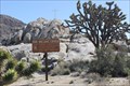
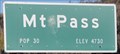 view gallery view gallery N9.2 km N9.2 km
|  Mountain Pass, California ~ Population 30 Mountain Pass, California ~ Population 30
in Population Signs This is the last summit as you travel Interstate 15 from California to Nevada. posted by: brwhiz location: California date approved: 03/18/2011 last visited: 03/08/2016 |
 view gallery view galleryN9.2 km |  Mountain Pass, California Mountain Pass, California
in Wikipedia Entries Mountain Pass has what is probably the smallest population of any recognized entity in the state of California. posted by: brwhiz location: California date approved: 03/26/2011 last visited: 03/08/2016 |
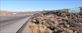
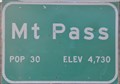
 view gallery view galleryN9.2 km |  Mountain Pass, California - Interstate 15 Northbound - Elevation 4730 feet Mountain Pass, California - Interstate 15 Northbound - Elevation 4730 feet
in Elevation Signs This is the last summit as you travel Interstate 15 from California to Nevada. From here it's downhill all the way. posted by: brwhiz location: California date approved: 03/18/2011 last visited: 03/30/2012 |
 view gallery view gallery NE9.3 km NE9.3 km
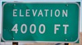
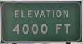
| Mountain Pass, North Grade ~ Interstate 15 Northbound - Elevation 4000 feet in Elevation Signs Passing down through the 4000 level on the way into Nevada. posted by: brwhiz location: California date approved: 03/18/2011 last visited: 03/30/2012 |
 view gallery view galleryN9.3 km | Mountain Pass, California ~ Population 30 in Population Signs Mountain Pass is so small and so high its altitude is almost 160 times its population. posted by: brwhiz location: California date approved: 03/15/2012 last visited: 03/08/2016 |
 view gallery view galleryN9.3 km | Mountain Pass, California - Interstate 15 Southbound - Elevation 4730 feet in Elevation Signs Mountain Pass is a very small town with a very big mine. posted by: brwhiz location: California date approved: 03/15/2012 last visited: 03/08/2016 |
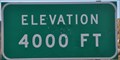 view gallery view galleryNE9.3 km | Mountain Pass, North Grade ~ Interstate 15 Southbound - Elevation 4000 feet in Elevation Signs Passing upward through 4000 feet just below Mountain Pass, California. posted by: brwhiz location: California date approved: 03/15/2012 last visited: 03/08/2016 |
 view gallery view gallery NW12.7 km NW12.7 km
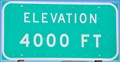
| Mountain Pass, South Grade ~ Interstate 15 Northbound - Elevation 4000 feet in Elevation Signs Passing up through the 4000 foot level leaving the saddle and climbing toward Mountain Pass. posted by: brwhiz location: California date approved: 03/18/2011 last visited: 03/30/2012 |
 view gallery view galleryNW12.9 km | Mountain Pass, South Grade ~ Interstate 15 Southbound - Elevation 4000 feet in Elevation Signs Passing down through 4000 feet heading into the saddle between Mountain Pass and Halloran Springs. posted by: brwhiz location: California date approved: 03/15/2012 last visited: 03/08/2016 |
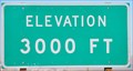 view gallery view galleryNE14.2 km | Mountain Pass, North Grade - Interstate 15 Northbound - Elevation 3000 feet in Elevation Signs Dropping through 3000 feet on the long straight stretch to the desert floor and the casinos at Primm. posted by: brwhiz location: California date approved: 03/18/2011 last visited: 03/08/2016 |
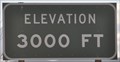 view gallery view galleryNE14.3 km | Mountain Pass, North Grade ~ Interstate 15 Southbound - Elevation 3000 feet in Elevation Signs You are passing upward through 3000 feet on your way to Mountain Pass. posted by: brwhiz location: California date approved: 03/15/2012 last visited: 05/24/2016 |
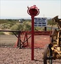 view gallery view galleryNW14.8 km |  Red Bell - Nipton, CA Red Bell - Nipton, CA
in Bells A red bell on a pole can be seen at a Shell gas station in Nipton, off of Interstate 15. posted by: bluesnote location: California date approved: 10/22/2016 last visited: 10/22/2016 |
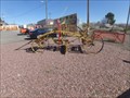 view gallery view galleryNW14.8 km |  1890's Austin Steel Reversible Road Machine - I-15/Cima Rd, CA 1890's Austin Steel Reversible Road Machine - I-15/Cima Rd, CA
in Preserved Machines on Public Display Preserved late 19th-century road grader on display at a service station on I15. posted by: jiggs11 location: California date approved: 03/27/2016 last visited: never |
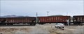 view gallery view galleryS16.7 km |  Cima Grade Crossing Cima Grade Crossing
in Active Rail Locations The grade crossing at the ghost town of Cima is another good place for watching trains in the Mohave National preserve. posted by: brwhiz location: California date approved: 11/02/2012 last visited: 03/08/2016 |
 view gallery view galleryS16.7 km |  Cima, CA 92323 (Closed) Cima, CA 92323 (Closed)
in U.S. Post Offices In the middle of the Mojave National Preserve. One of the most remote post offices in California. posted by:  michael3900 michael3900 location: California date approved: 09/11/2008 last visited: 03/08/2016 |
 view gallery view gallery W16.9 km W16.9 km
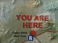
|  You Are Here In The California Desert - Valley Wells, CA You Are Here In The California Desert - Valley Wells, CA
in 'You Are Here' Maps This you are here map shows you where you are in relationship to Las Vegas and Los Angeles. posted by: bluesnote location: California date approved: 11/04/2012 last visited: 02/25/2016 |
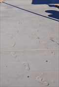 view gallery view galleryW16.9 km |  Petrosomatoglyphs at Valley Wells Petrosomatoglyphs at Valley Wells
in Petrosomatoglyphs Numerous Petrosomatoglyphs are found in the concrete surfaces at the Northbound Interstate 15 Valley Wells Highway Rest Area northeast of Baker, California. posted by: brwhiz location: California date approved: 11/12/2012 last visited: 02/24/2015 |
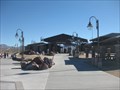 view gallery view galleryW16.9 km |  Valley Wells Safety Rest Area Eastbound Valley Wells Safety Rest Area Eastbound
in Highway Rest Areas For those heading to Nevada on I15, this rest area serves as a stop along the way. posted by: ChapterhouseInc location: California date approved: 02/10/2011 last visited: 03/08/2016 |
 view gallery view galleryW17.1 km |  Valley Wells - Baker, CA Valley Wells - Baker, CA
in E Clampus Vitus Historical Markers Located at the Valley Wells wetbound rest area. posted by: ChapterhouseInc location: California date approved: 02/08/2011 last visited: 04/11/2015 |
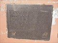 view gallery view galleryW17.1 km |  Valley Wells - Baker, CA Valley Wells - Baker, CA
in California Historical Markers Located at the Valley Wells wetbound rest area. posted by: ChapterhouseInc location: California date approved: 02/23/2011 last visited: 02/08/2019 |
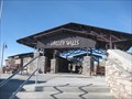 view gallery view galleryW17.1 km | Valley Wells Safety Rest Area Westbound in Highway Rest Areas Westbound rest area along I15 near the CA/NV border. posted by: ChapterhouseInc location: California date approved: 02/09/2011 last visited: 02/08/2019 |
|