 view gallery view gallery SW10.6 km SW10.6 km
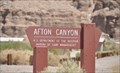
|   Afton Canyon Campground Afton Canyon Campground
in Campgrounds This Campground is located about 3.5 miles by gravel road east of Interstate Highway 15 Exit 221 between Barstow and Baker, California . posted by:  brwhiz brwhiz location: California date approved: 08/23/2013 last visited: never |
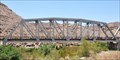 view gallery view gallerySW10.6 km |  Afton Canyon Railroad Bridge Afton Canyon Railroad Bridge
in Active Rail Locations This Active Rail Location is next to the Afton Canyon Campground, located about 3.5 miles by gravel road east of Interstate Highway 15 Exit 221 between Barstow and Baker, California. posted by: brwhiz location: California date approved: 08/23/2013 last visited: never |
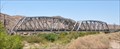 view gallery view gallerySW10.6 km |  Afton Canyon Railroad Bridge - San Bernadino County, CA Afton Canyon Railroad Bridge - San Bernadino County, CA
in Railroad Bridges This Railroad Bridge carries mainline tracks across the Mojave River at Afton Canyon on its run between Barstow and Las Vegas. posted by: brwhiz location: California date approved: 08/23/2013 last visited: never |
 view gallery view gallerySW10.6 km |  Afton Canyon Railroad Bridge Afton Canyon Railroad Bridge
in Truss Bridges This Truss Bridge carries mainline railroad trackage across the Mojave River at Afton Canyon on its run between Barstow and Las Vegas. posted by: brwhiz location: California date approved: 08/23/2013 last visited: never |
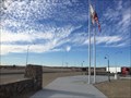 view gallery view gallerySW16.9 km |  Clyde V. Kane Northbound Rest Area - Newberry Springs, CA Clyde V. Kane Northbound Rest Area - Newberry Springs, CA
in Free Overnight RV Parking Locations A newly refurbished rest area along Interstate 15. posted by: bluesnote location: California date approved: 02/20/2016 last visited: 02/20/2016 |
 view gallery view gallerySW16.9 km |  Clyde V. Kane Northbound Rest Area - Newberry Springs, CA Clyde V. Kane Northbound Rest Area - Newberry Springs, CA
in Highway Rest Areas A newly refurbished rest area along Interstate 15. posted by: bluesnote location: California date approved: 12/16/2015 last visited: 12/16/2015 |
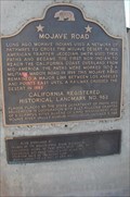
 view gallery view gallerySW16.9 km |  Mojave Road - Mojave Desert, California Mojave Road - Mojave Desert, California
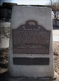
in Ancient Traces and Roads This California Historic Landmark is located in the desert at a rest stop along I-15 North on the way to Las Vegas...and marks the Indian trails which eventually were used as wagon roads...and now an Insterstate Highway.
posted by: Metro2 location: California date approved: 11/21/2009 last visited: 12/04/2015 |
 view gallery view gallerySW16.9 km |  Mojave Road - California Mojave Road - California
in E Clampus Vitus Historical Markers This California Historic Landmark is located in the desert at a rest stop along I-15 North on the way to Las Vegas. posted by: Metro2 location: California date approved: 11/20/2009 last visited: 12/04/2015 |
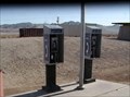 view gallery view gallerySW16.9 km |  Mojave Road Phones - Mojave Desert, California Mojave Road Phones - Mojave Desert, California
in Payphones These phones are at a rest stop about 30 miles north of Barstow on California's Interstate 15. posted by: Metro2 location: California date approved: 11/21/2009 last visited: 02/13/2011 |
 view gallery view gallerySW16.9 km |  Mojave Road -- Mojave Desert, California Mojave Road -- Mojave Desert, California
in Wagon Roads and Trails This California Historic Landmark is located in the desert at a rest stop along I-15 North on the way to Las Vegas...and marks the Indian trails which eventually were used as wagon roads...and now an Interstate Highway.
posted by: Metro2 location: California date approved: 11/21/2009 last visited: 12/04/2015 |
 view gallery view gallerySW16.9 km |  Mojave Road - Newberry Springs, CA Mojave Road - Newberry Springs, CA
in Cairns A CA state marker at a rest area along interstate 15. posted by: bluesnote location: California date approved: 02/19/2022 last visited: never |
 view gallery view gallerySW16.9 km |  Mojave Road Mojave Road
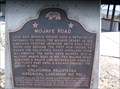
in Wikipedia Entries The Mojave Road is a historic off-road route across the Mojave National Preserve. The road served westward travelers in the 1800s by leading them between watering holes across the Mojave Desert. posted by: JacobBarlow location: California date approved: 01/22/2008 last visited: 12/04/2015 |
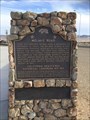
 view gallery view gallerySW16.9 km |  FIRST -- Non-Indian to Reach the California Coast Overland From Mid-America - Newberry Springs, CA FIRST -- Non-Indian to Reach the California Coast Overland From Mid-America - Newberry Springs, CA
in First of its Kind A CA state marker at a rest area along interstate 15. posted by: bluesnote location: California date approved: 12/14/2015 last visited: 12/14/2015 |
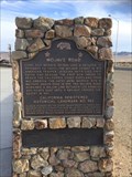
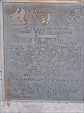
 view gallery view gallerySW16.9 km |  Mojave Road - Newberry Springs, CA Mojave Road - Newberry Springs, CA
in California Historical Markers Long ago, Mohave Indians used a network of pathways to cross the Mojave Desert. In 1826, American trapper Jedediah Smith used their paths and became the first non-Indian to reach the California coast overland from mid-America.... posted by: JacobBarlow location: California date approved: 02/01/2008 last visited: 12/04/2015 |
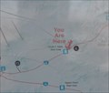 view gallery view gallerySW16.9 km |  Clyde V. Kane Safety Rest Area Northbound Clyde V. Kane Safety Rest Area Northbound
in 'You Are Here' Maps You Are Here at the Clyde V. Kane Safety Rest Area on northbound Interstate 15 beyween Barstow and Baker, California. posted by: brwhiz location: California date approved: 06/07/2011 last visited: never |
 view gallery view gallery NE18.2 km NE18.2 km
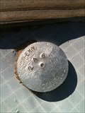
|  EKN 246 Control Mark - Zyzzx, CA EKN 246 Control Mark - Zyzzx, CA
in U.S. Benchmarks This control mark is located at a geocache. posted by: bluesnote location: California date approved: 01/01/2013 last visited: 02/25/2016 |
 view gallery view gallery E19.2 km E19.2 km
|  Town With Last Name in the Atlas: Zzyzx, CA Town With Last Name in the Atlas: Zzyzx, CA
in Roadside Attractions Old Mineral Spa and resort, named by its founder in the belief that it was the last word in the English language (it's not)! posted by: jiggs11 location: California date approved: 04/03/2016 last visited: never |
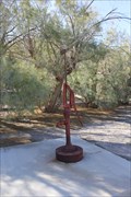 view gallery view galleryE19.2 km |  Old Water Pump -- Zzyzx CA Old Water Pump -- Zzyzx CA
in Hand Operated Water Pumps This old water pump was installed when Zzyzx was a spa run by a quack. posted by: Benchmark Blasterz location: California date approved: 04/11/2016 last visited: 10/22/2016 |
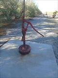 view gallery view galleryE19.2 km | Hand Pump - Zzyzx, CA in Hand Operated Water Pumps Old hand pump located near the parking lot entrance to the old Zzyzx Mineral Spa. posted by: jiggs11 location: California date approved: 04/06/2016 last visited: never |
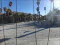
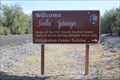
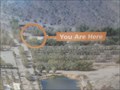 view gallery view galleryE19.2 km | You Are Here - Zzyzx, CA in 'You Are Here' Maps You Are Here Marker on the grounds of the old Zzyzx Spa and Mineral Springs, now the CSU Desert Studies Center. posted by: jiggs11 location: California date approved: 04/03/2016 last visited: never |
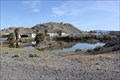 view gallery view galleryE19.3 km | Zzyzx -- nr Baker CA in Roadside Attractions The former quacky mineral spa oasis of Zzyzx off the I-15 is worth a visit posted by: Benchmark Blasterz location: California date approved: 04/03/2016 last visited: 02/25/2016 |
 view gallery view galleryE19.3 km |  "Zzyzx: An Unlikely Home of Hucksterism and Miracle Cures" -- Zzyzx, CA "Zzyzx: An Unlikely Home of Hucksterism and Miracle Cures" -- Zzyzx, CA
in News Article Locations This article from the LA Times captures the weird and wonderful about the quirky place called Zzyzx. posted by: Benchmark Blasterz location: California date approved: 04/02/2016 last visited: 03/08/2016 |
 view gallery view galleryE19.3 km | Zzyzx Rd. Marker in E Clampus Vitus Historical Markers At the end of Zzyzx Rd. posted by: toponym location: California date approved: 04/06/2009 last visited: 02/25/2016 |
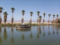 view gallery view galleryE19.3 km |  Zzyzx Mineral Springs Fountain Zzyzx Mineral Springs Fountain
in Fountains This is an old fountain from when this complex was a resort. posted by: TerryDad2 location: California date approved: 06/05/2007 last visited: 03/08/2016 |
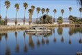
 view gallery view galleryE19.3 km |  Soda Springs -- Zzyzx CA Soda Springs -- Zzyzx CA
in Natural Springs Soda Springs at Zzyzx has been used as an important watering place in the desert by animals and humans for thousands of years. posted by: Benchmark Blasterz location: California date approved: 04/02/2016 last visited: 03/08/2016 |
|