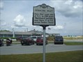
 view gallery view gallery SW10.8 km SW10.8 km
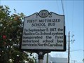
|   First Motorized School Bus ---- C-47 First Motorized School Bus ---- C-47
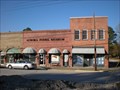
in North Carolina Historical Markers Located on Broad St. and Church St. in Oriental NC posted by:  Countrydragon Countrydragon location: North Carolina date approved: 01/18/2010 last visited: 01/02/2013 |
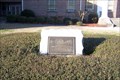
 view gallery view gallerySW10.8 km |  First Motorized School Bus in North Carolina First Motorized School Bus in North Carolina
in First of its Kind Located on Broad St. and Church St. in Oriental NC posted by: Countrydragon location: North Carolina date approved: 01/14/2010 last visited: 01/01/2013 |
 view gallery view gallery NW12.6 km NW12.6 km
|  Feather and Fur Sporting Clays - Bayboro, NC Feather and Fur Sporting Clays - Bayboro, NC
in Shooting Ranges Great shooting facility for family, groups or individual. Excellent instruction. posted by: oldtool53 location: North Carolina date approved: 10/27/2007 last visited: 01/14/2010 |
 view gallery view gallery W15.9 km W15.9 km
|  Pamlico County Confederate Memorial in Bayboro North Carolina Pamlico County Confederate Memorial in Bayboro North Carolina
in American Civil War Monuments and Memorials This wonderful bronze memorial site on a rounded stone on the left side of Pamlico County Courthouse. It is a reminder to all who pass it that even though these men dead for the southern they were fighting for what they believed in. posted by: Countrydragon location: North Carolina date approved: 01/15/2010 last visited: 01/16/2010 |
 view gallery view gallerySW25.4 km |  Cherry Branch-Minnesott Beach, Nr. Cherry Point, NC Cherry Branch-Minnesott Beach, Nr. Cherry Point, NC
in Ferries and Ferry Landings NC ferry across the Neuse River. Southern terminal. posted by: garmin_geek location: North Carolina date approved: 01/28/2009 last visited: 05/11/2024 |
 view gallery view gallery E27.8 km E27.8 km
|  Blackbeard was killed here! Blackbeard was killed here!
in Pirates NC Highway marker tells of Blackbeard's death. posted by: fatcat161 location: North Carolina date approved: 05/06/2009 last visited: never |
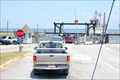
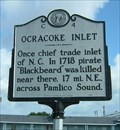 view gallery view galleryE27.8 km | Ocracoke Inlet, Marker C-4 in North Carolina Historical Markers Since Europeans first began exploring and colonizing America, Ocracoke Inlet has remained the only reliable inlet to Pamlico Sound. This marker is at the North Carolina Ferry Terminal on Cedar Island. posted by: showbizkid location: North Carolina date approved: 06/28/2006 last visited: 01/12/2010 |
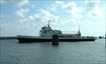 view gallery view galleryE27.8 km | Cedar Island Ferry Terminal, North Carolina Ferry System in Ferries and Ferry Landings The Cedar Island Terminal is the southern terminus of the Cedar Island-Ocracoke Island ferry route. posted by: showbizkid location: North Carolina date approved: 06/26/2006 last visited: 05/01/2009 |
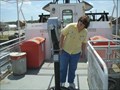 view gallery view galleryE27.8 km |  Binocular on Cedar Island Ferry Binocular on Cedar Island Ferry
in Coin-Op Binoculars Coin-Op Binocular located on the ferry. posted by: fatcat161 location: North Carolina date approved: 05/10/2009 last visited: never |
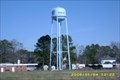 view gallery view galleryNW28.5 km |  Town of Aurora NC Town of Aurora NC
in Water Towers Water tower for the town of Aurora posted by: oldtool53 location: North Carolina date approved: 01/08/2008 last visited: 11/10/2022 |
 view gallery view galleryNW28.6 km |  Aurora Fossil Museum - Aurora, NC Aurora Fossil Museum - Aurora, NC
in History Museums Fossil Museum in Aurora NC. posted by: ECPirates location: North Carolina date approved: 12/13/2008 last visited: 11/09/2022 |
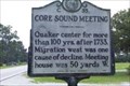 view gallery view gallery S31.7 km S31.7 km
| Core Sound Meeting -- C-35 in North Carolina Historical Markers Located on NC-101, Harlowe, NC posted by: Countrydragon location: North Carolina date approved: 01/14/2010 last visited: 12/03/2003 |
 view gallery view galleryNW31.9 km |  Giant Dragline Bucket at Aurora NC Giant Dragline Bucket at Aurora NC
in Roadside Attractions Giant dragline bucket at mine entrance posted by: oldtool53 location: North Carolina date approved: 01/14/2008 last visited: never |
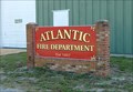 view gallery view gallery SE34 km SE34 km
|  Atlantic Fire Department Atlantic Fire Department
in Firehouses The volunteer fire department in tiny Atlantic, North Carolina, population 858. posted by: showbizkid location: North Carolina date approved: 06/28/2006 last visited: 06/25/2006 |
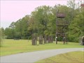
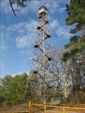 view gallery view galleryNW34.4 km |  Redditt Fire Tower Redditt Fire Tower
in Look-Out Towers Redditt Fire Tower, Beaufort County, NC posted by: weblookout location: North Carolina date approved: 03/01/2007 last visited: 01/12/2007 |
 view gallery view galleryS35.4 km |  Williston United Methodist Church, formerly Springfield Methodist Episcopal Church, Williston, North Carolina Williston United Methodist Church, formerly Springfield Methodist Episcopal Church, Williston, North Carolina
in This Old Church Williston United Methodist Church was originally called Springfield Methodist Episcopal Church, South and was built in 1883. posted by: showbizkid location: North Carolina date approved: 07/22/2006 last visited: 06/24/2006 |
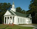 view gallery view galleryS35.4 km | Williston United Methodist Church, Williston, North Carolina in Country Churches Springfield Methodist Episcopal Church was built in 1883. The church is now called Williston United Methodist Church. It is located in the "Down East" community of Williston. posted by: showbizkid location: North Carolina date approved: 07/22/2006 last visited: 06/25/2006 |
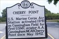 view gallery view gallerySW35.7 km | Cherry Point ---- C-68 in North Carolina Historical Markers Located on NC 101 at Cunningham Blvd in Havelock NC posted by: Countrydragon location: North Carolina date approved: 01/14/2010 last visited: 01/01/2013 |
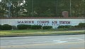 view gallery view gallerySW36 km |  Marine Corps Air Station, Cherry Point Marine Corps Air Station, Cherry Point
in Military Installations Marine Corps Air Station, Cherry Point is the largest MCAS in the world. It is located in Havelock, North Carolina. More than 49,000 people make up the Cherry Point-related population, including active duty and retired Marines, the civilian workforce, and their dependents. posted by: showbizkid location: North Carolina date approved: 07/22/2006 last visited: 01/01/2013 |
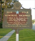 view gallery view gallerySW36.2 km |  U.S. Highway 70, Havelock, North Carolina U.S. Highway 70, Havelock, North Carolina
in Blue Star Memorial Highway Markers The Blue Star Memorial Marker in Havelock, North Carolina, home of the Marine Corps Naval Air Station, Cherry Point. posted by: showbizkid location: North Carolina date approved: 07/05/2006 last visited: 08/25/2013 |
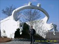
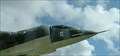 view gallery view gallerySW36.4 km |  AV-8A Harrier, Havelock, North Carolina AV-8A Harrier, Havelock, North Carolina
in Static Aircraft Displays This static aircraft display in Havelock, North Carolina has actually become the city seal. Marine Corps Air Station, Cherry Point is located in Havelock. posted by: showbizkid location: North Carolina date approved: 07/02/2006 last visited: 01/01/2013 |
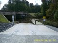 view gallery view gallerySW36.7 km |  Slocum Creek boat ramp Havelock N.C. Slocum Creek boat ramp Havelock N.C.
in Boat Ramps Slocum Creek boat ramp is a popular launch site for fishing, kayaking and canoeing. Located in the city of Havelock near the Cherry Point Marine Corps Air Station. Slocum Creek leads to the Neuse River. The ramp is next to highway 70. posted by: oldtool53 location: North Carolina date approved: 10/08/2008 last visited: 11/09/2008 |
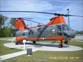 view gallery view gallerySW36.9 km | HH-46D Boeing Vertol Search and Rescue Helicopter in Static Aircraft Displays Displayed at the city of Havelock visitors center near the Cherry Point Marine Corps Air Station. posted by: oldtool53 location: North Carolina date approved: 10/16/2008 last visited: 05/13/2023 |
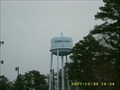 view gallery view galleryW37.3 km | Craven County NC - Water Tower in Water Towers Water tower for the Craven County System. posted by: oldtool53 location: North Carolina date approved: 12/30/2007 last visited: never |
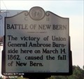 view gallery view galleryW37.5 km | Battle of New Bern (C-11) in North Carolina Historical Markers The victory of Union General Ambrose Burnside here on March 14, 1862, caused the fall of New Bern. posted by: Don.Morfe location: North Carolina date approved: 03/26/2020 last visited: 10/23/2021 |
|