 view gallery view gallery SW7.6 km SW7.6 km
|   El Calderon - Cibola County, NM El Calderon - Cibola County, NM
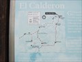
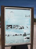
in 'You Are Here' Maps "You are Here" sign for trails and roads in the El Calderon area of El Malpais National Monument. posted by:  linkys linkys location: New Mexico date approved: 11/14/2009 last visited: 07/29/2014 |
 view gallery view gallerySW7.6 km |  Calderon Trail - Cibola County, NM Calderon Trail - Cibola County, NM
in Scenic Hikes Trail within El Malpais National Monument that explores various volcanic features. posted by: linkys location: New Mexico date approved: 11/28/2009 last visited: 08/19/2019 |
 view gallery view gallerySW7.6 km |  El Calderon Trail - Cibola County, NM El Calderon Trail - Cibola County, NM
in Self Guided Walks and Trails Trail within El Malpais National Monument that leads to exploration of various volcanic areas. posted by: linkys location: New Mexico date approved: 11/27/2009 last visited: 02/08/2019 |
 view gallery view gallerySW7.6 km |  Calderon Trail System Trailhead - Cibola County, NM Calderon Trail System Trailhead - Cibola County, NM
in Hiking and walking trailheads Trail within El Malpais National Monument that leads to exploration of various volcanic areas. posted by: linkys location: New Mexico date approved: 11/27/2009 last visited: 04/08/2017 |
 view gallery view gallery S7.6 km S7.6 km
|  Zuni-Acoma Trail - El Malpais Natl. Mon., NM Zuni-Acoma Trail - El Malpais Natl. Mon., NM
in Ancient Traces and Roads The Zuni-Acoma trail is a long established over 1000-year old Puebloan Indian trail between the Acoma and Zuni Pueblos. posted by:  Benchmark Blasterz Benchmark Blasterz location: New Mexico date approved: 08/21/2014 last visited: 02/08/2019 |
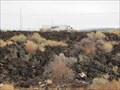 view gallery view gallerySW7.9 km |  Grants Lava Flow Grants Lava Flow
in U.S. National Natural Landmarks Grants Lava Flow is one of the best examples of recent surface lava flows. posted by: linkys location: New Mexico date approved: 11/18/2009 last visited: 03/28/2015 |
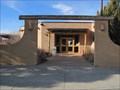
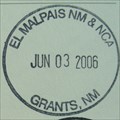 view gallery view gallerySW8.4 km |  El Malpais National Monument, Northwest Info Center El Malpais National Monument, Northwest Info Center
in NPS Passport Cancellation Stations This is one of three centers for the El Malpais NM & NCA. posted by: leadhiker location: New Mexico date approved: 12/29/2009 last visited: 01/18/2023 |
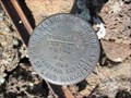 view gallery view gallerySW8.9 km |  BLM Cadastral Survey Marker T8NR11W BLM Cadastral Survey Marker T8NR11W
in U.S. Benchmarks BLM Survey Marker located in El Mapais National Monument. posted by: linkys location: New Mexico date approved: 11/17/2009 last visited: never |
 view gallery view gallery W11.9 km W11.9 km
|  Continental Divide - 7882' - Cibola County, NM Continental Divide - 7882' - Cibola County, NM
in Elevation Signs Continental Divide sign on Hwy 53 in Cibola National Forest. posted by: linkys location: New Mexico date approved: 11/14/2009 last visited: 08/19/2019 |
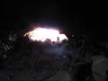
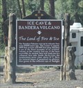 view gallery view galleryW12.1 km |  Ice Cave & Bandera Volcano - nr Bandera Volcano NM Ice Cave & Bandera Volcano - nr Bandera Volcano NM
in New Mexico Historical Markers The historic marker outside of the Bandera Volcano and Ice Cave visitor center posted by: Benchmark Blasterz location: New Mexico date approved: 08/22/2014 last visited: 08/19/2019 |
 view gallery view galleryW12.1 km |  Bandera Ice Cave and Crater -- nr Candelaria Trading Post NM Bandera Ice Cave and Crater -- nr Candelaria Trading Post NM
in Birdwatching Locations One of the best places to see hummingbirds is right outside of the Bandera Ice Cave visitor center posted by: Benchmark Blasterz location: New Mexico date approved: 08/26/2014 last visited: 08/27/2014 |
 view gallery view galleryW12.1 km |  Bandera Ice cave & Crater -- nr Candelaria Trading Post NM Bandera Ice cave & Crater -- nr Candelaria Trading Post NM
in Official Local Tourism Attractions The amazing Bandera Ice Cave and Bandera Crater are well worth a stop when travelling in this part of northern NM posted by: Benchmark Blasterz location: New Mexico date approved: 08/23/2014 last visited: 08/23/2014 |
 view gallery view galleryW12.2 km |  The Land of Fire & Ice The Land of Fire & Ice
in Mom and Pop Rock Shops The Historic Trading Post here has ancient artifacts on display. Most of these were found in the lava and some date back 1,200 years! posted by: Colombian Princess location: New Mexico date approved: 07/17/2008 last visited: 07/29/2014 |
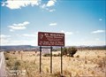
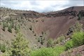 view gallery view galleryW12.4 km |  Bandera Crater - nr Candelaria Trading Post, NM Bandera Crater - nr Candelaria Trading Post, NM
in Volcano Watching The waymark coordinates are for the viewing overlook for the center of this long-dormant volcano at the Bandera Volcano and Ice Cave attraction on N 53, part of the Zuni-Bandera lava field. posted by: Benchmark Blasterz location: New Mexico date approved: 08/22/2014 last visited: 08/19/2019 |
 view gallery view galleryW12.4 km | Bandera Ice Cave Benchmark in U.S. Benchmarks This benchmark is located in the Bandera Ice Cave. posted by: urbaneasy & easier location: New Mexico date approved: 09/03/2008 last visited: 07/29/2014 |
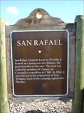 view gallery view gallery NE12.7 km NE12.7 km
| San Rafael in New Mexico Historical Markers A New Mexico OSHM just south of Grants on Hwy. 53. posted by: leadhiker location: New Mexico date approved: 06/09/2011 last visited: never |
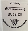 view gallery view gallery SE14.2 km SE14.2 km
|  BLM El Malpais National Conservation Area -- nr Grants NM BLM El Malpais National Conservation Area -- nr Grants NM
in National Public Lands Passport Locations The Visitor Center for the Bureau of Land Management's El Malpais National Conservation Area, which is distinct and separate from El Malpais National Monument posted by: Benchmark Blasterz location: New Mexico date approved: 09/12/2014 last visited: 06/21/2014 |
 view gallery view gallerySE14.2 km |  El Malpais National Conservation Area Visitors Center- Grants, NM El Malpais National Conservation Area Visitors Center- Grants, NM
in Guest Books Guestbook is in BLM Visitor center serving both El Malpais National Monument and El Malpais National Conservation Area in northwestern New Mexico. posted by: linkys location: New Mexico date approved: 11/14/2009 last visited: 02/02/2017 |
 view gallery view gallerySE14.2 km |  El Malpais National Conservation Area - Grants, NM El Malpais National Conservation Area - Grants, NM
in Tourist Information Centers - Visitor Centers BLM staffed visitor center providing information on El Malpais National Conservation Area and El Malpais National Monument. posted by: linkys location: New Mexico date approved: 11/14/2009 last visited: 02/02/2017 |
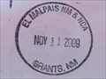 view gallery view gallerySE14.2 km | El Malpais National Monument & NCA - Grants, NM in NPS Passport Cancellation Stations One of three visitor centers with an El Malpias passport stamp serving the Park. posted by: linkys location: New Mexico date approved: 11/17/2009 last visited: 02/08/2019 |
 view gallery view galleryNE15.4 km |  El Malpais National Monument - Grants NM El Malpais National Monument - Grants NM
in Wikipedia Entries El Malpais National Monument is a National Monument located in western New Mexico. The name El Malpais is from the Spanish term Malpaís, meaning badlands, due to the extremely barren and dramatic volcanic field that covers much of the park's area. posted by: Don.Morfe location: New Mexico date approved: 01/17/2023 last visited: 01/17/2023 |
 view gallery view galleryNE15.4 km |  El Malpais National Monument - Grants NM El Malpais National Monument - Grants NM
in National Parks of the World El Malpais National Monument is a National Monument located in western New Mexico. The name El Malpais is from the Spanish term Malpaís, meaning badlands, due to the extremely barren and dramatic volcanic field that covers much of the park's area. posted by: Don.Morfe location: New Mexico date approved: 01/17/2023 last visited: 01/17/2023 |
 view gallery view galleryNE15.4 km | ") El Malpais National Monument - Grants NM El Malpais National Monument - Grants NM
in National Parks (U.S.) El Malpais National Monument is a National Monument located in western New Mexico. The name El Malpais is from the Spanish term Malpaís, meaning badlands, due to the extremely barren and dramatic volcanic field that covers much of the park's area. posted by: Don.Morfe location: New Mexico date approved: 01/17/2023 last visited: 01/17/2023 |
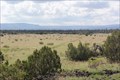
 view gallery view galleryNE15.4 km | El Malpais National Monument - Grants NM in Official Local Tourism Attractions The primeval black basalt terrain of El Malpais was created by volcanic forces over the past million years. Molten lava spread out over the high desert from dozens of eruptions to create cinder cones, shield volcanos, collapses, trenches, and caves. posted by: Don.Morfe location: New Mexico date approved: 01/17/2023 last visited: 01/17/2023 |
 view gallery view galleryNE15.4 km |  El Malpais National Monument - Grants NM El Malpais National Monument - Grants NM
in Satellite Imagery Oddities The primeval black basalt terrain of El Malpais was created by volcanic forces over the past million years. Molten lava spread out over the high desert from dozens of eruptions to create cinder cones, shield volcanos, collapses, trenches. posted by: Don.Morfe location: New Mexico date approved: 01/17/2023 last visited: 01/17/2023 |
|