 view gallery view gallery E3.1 km E3.1 km
|   Colbert Ferry "You Are Here" Map - Natchez Trace, AL Colbert Ferry "You Are Here" Map - Natchez Trace, AL
in 'You Are Here' Maps "You Are Here" map located at the Colbert Ferry National Park Service contact station on the Natchez Trace in north Alabama. posted by:  hummerstation hummerstation location: Alabama date approved: 03/18/2011 last visited: never |
 view gallery view galleryE7.4 km |  Rock Spring Trail -- Natchez Trace Pkwy nr Tennessee River, Lauderdale Co. AL Rock Spring Trail -- Natchez Trace Pkwy nr Tennessee River, Lauderdale Co. AL
in Hiking and walking trailheads A sign along the Natchez Trace Parkway in Lauderdale Co. AL at the Rock Spring Trailhead posted by: Benchmark Blasterz location: Alabama date approved: 10/21/2017 last visited: 08/03/2017 |
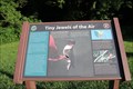 view gallery view galleryE7.4 km |  Tiny Jewels of the Air -- Natchez Trace Pkwy nr Tennessee River, Lauderdale Co. AL Tiny Jewels of the Air -- Natchez Trace Pkwy nr Tennessee River, Lauderdale Co. AL
in Flora and Fauna Information Signs A flora and fauna information sign along the Natchez Trace Parkway in Lauderdale Co. AL posted by: Benchmark Blasterz location: Alabama date approved: 10/15/2017 last visited: 08/03/2017 |
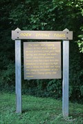
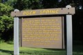 view gallery view galleryE7.4 km |  Natchez Trace: Rock Spring, Lauderdale Co. AL Natchez Trace: Rock Spring, Lauderdale Co. AL
in National Scenic Byways A National Park Service sign about Rock Spring, along the Natchez Trace in Alabama posted by: Benchmark Blasterz location: Alabama date approved: 11/02/2017 last visited: 08/04/2017 |
 view gallery view galleryE7.4 km | Natchez Trace: Rock Spring Trail nr Tennessee River, Lauderdale Co. AL in National Scenic Byways A sign along the Natchez Trace Parkway in Lauderdale Co. AL at the Rock Spring Trailhead posted by: Benchmark Blasterz location: Alabama date approved: 11/02/2017 last visited: 08/04/2017 |
 view gallery view gallery S8.7 km S8.7 km
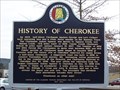
|  History Of Cherokee - Cherokee, AL History Of Cherokee - Cherokee, AL
in Alabama Historical Markers History Of Cherokee, Cherokee, AL posted by: hummerstation location: Alabama date approved: 03/10/2011 last visited: 08/29/2013 |
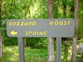 view gallery view gallery SW9.2 km SW9.2 km
| Natchez Trace Parkway - Buzzard Roost Spring, near Cherokee, AL in National Scenic Byways Along the 33-mile stretch of the Natchez Trace Parkway in Alabama, just off US Hwy 72. Home place and site of Inn run by Chickasaw Chieftain Levi Colbert (1759-1834). posted by:  Dulcimoore Dulcimoore location: Alabama date approved: 07/24/2011 last visited: 10/01/2016 |
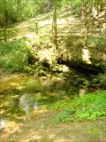 view gallery view gallerySW9.2 km |  Buzzard Roost Spring - Colbert County, AL Buzzard Roost Spring - Colbert County, AL
in Natural Springs Originally called Buzzard Sleep, changed to Buzzard Roost in 1801 by Levi Colbert, a renowned Chickasaw chieftain. The spring was a water source for the Colbert house which also served as an inn and stand for travelers on the Old Natchez Trace. posted by: Dulcimoore location: Alabama date approved: 07/25/2011 last visited: 10/01/2016 |
 view gallery view gallerySW9.7 km |  Shoe Tree - Hwy 72 - Alabama Shoe Tree - Hwy 72 - Alabama
in Shoe Trees This Shoe Tree is on the north side of U.S. Highway 72 about 4 miles west of Cherokee, Alabama and 4 miles west of the Mississippi border. posted by: PeterNoG location: Alabama date approved: 01/20/2012 last visited: 10/01/2016 |
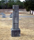 view gallery view gallery SE14 km SE14 km
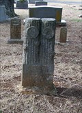
|  Alexander G. Shull - Barton, AL Alexander G. Shull - Barton, AL
in Woodmen of the World Grave Markers/Monuments The Alexander G. Shull Woodmen of the World marker is located in Barton Cemetery. posted by: hummerstation location: Alabama date approved: 02/20/2015 last visited: never |
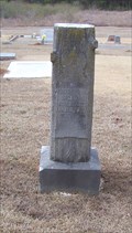 view gallery view gallerySE14 km | Joseph A. Nichols - Barton, AL in Woodmen of the World Grave Markers/Monuments The Joseph A. Nichols Woodmen of the World marker is located in Barton Cemetery. posted by: hummerstation location: Alabama date approved: 02/20/2015 last visited: never |
 view gallery view gallerySE14 km | Charles E. Weatherbee - Barton, AL in Woodmen of the World Grave Markers/Monuments The Charles E. Weatherbee Woodmen of the World marker is located in Barton Cemetery. posted by: hummerstation location: Alabama date approved: 02/20/2015 last visited: never |
 view gallery view gallerySE14.2 km | William D. Burrow - Barton, AL in Woodmen of the World Grave Markers/Monuments The William D. Burrow Woodmen of the World marker is located in Barton Cemetery. posted by: hummerstation location: Alabama date approved: 02/20/2015 last visited: never |
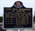 view gallery view gallerySE14.2 km | Civil War Skirmishes at Barton/Civil War Skirmishes at the Barton Cemetery - Barton, AL in Alabama Historical Markers In 1862-63, Confederate forces fought several sharp skirmishes near Barton as they sought to repel or delay Union expeditions invading the Tennessee Valley from the Federal stronghold at Corinth, Mississippi. posted by: hummerstation location: Alabama date approved: 02/08/2015 last visited: never |
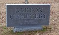 view gallery view gallerySE14.2 km |  Barton Cemetery - Barton, AL Barton Cemetery - Barton, AL
in Worldwide Cemeteries Barton Cemetery was established in 1816 by A. L. Garner. posted by: hummerstation location: Alabama date approved: 02/26/2015 last visited: never |
 view gallery view gallerySW14.3 km |  Mississippi on 72A Mississippi on 72A
in Border Crossings A scenic crossing in the hill country near the Natchez Trace. posted by: Scrawlinn location: Mississippi date approved: 05/19/2008 last visited: 08/03/2017 |
 view gallery view gallery W19.2 km W19.2 km
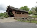
|  Spring Creek Cover Bridge, Iuka, MS. Spring Creek Cover Bridge, Iuka, MS.
in Covered Bridges A beautiful old covered bridge in historic Iuka, Mississippi. posted by: the federation location: Mississippi date approved: 05/01/2013 last visited: 10/02/2016 |
 view gallery view galleryW19.2 km |  Old Tishomingo County Courthouse, Iuka, MS. Old Tishomingo County Courthouse, Iuka, MS.
in Courthouses The former Tishimingo County County House has been preserved as the current Ishimingo County Historical Society. posted by: the federation location: Mississippi date approved: 08/30/2013 last visited: 10/01/2013 |
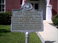
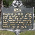 view gallery view galleryW19.2 km |  Iuka, Iuka, Tishomingo County, Mississippi Iuka, Iuka, Tishomingo County, Mississippi
in Mississippi Historical Markers Early look at Iuka. From Charter to world's fair. posted by: krsmith2 location: Mississippi date approved: 07/19/2013 last visited: 10/05/2013 |
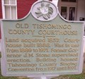 view gallery view galleryW19.3 km | Old Tishomingo County Courthouse, Iuka, Tishomingo County, Mississippi in Mississippi Historical Markers History of the Courthouse. posted by: krsmith2 location: Mississippi date approved: 07/19/2013 last visited: 10/01/2013 |
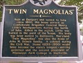 view gallery view galleryW19.3 km | Twin Magnolias, Iuka, Tishomingo County, Mississippi in Mississippi Historical Markers The history of this house,and some of the people that lived there. posted by: krsmith2 location: Mississippi date approved: 07/19/2013 last visited: 10/05/2013 |
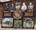 view gallery view galleryW19.3 km |  City Murals, Iuka,Tishomingo County, Mississippi City Murals, Iuka,Tishomingo County, Mississippi
in Murals City Mural that show the 150 years anniversary of the Civil War and the Battle of Iuka. posted by: krsmith2 location: Mississippi date approved: 07/23/2013 last visited: 10/05/2013 |
 view gallery view galleryW19.3 km |  Old Tishomingo County Courthouse History Museum, Iuka, MS Old Tishomingo County Courthouse History Museum, Iuka, MS
in History Museums A slice of the Old South found in a converted county courthouse. posted by: the federation location: Mississippi date approved: 08/30/2013 last visited: 10/01/2013 |
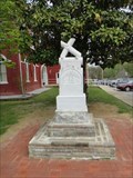 view gallery view galleryW19.3 km |  Tishomingo County Confederate Memorial, Iuka, MS Tishomingo County Confederate Memorial, Iuka, MS
in American Civil War Monuments and Memorials A rather unusual Confederate marker located in Iuka, MS. posted by: the federation location: Mississippi date approved: 08/30/2013 last visited: 09/30/2013 |
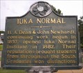 view gallery view galleryW19.8 km | Iuka Normal, Iuka, Tishomingo County, Mississippi in Mississippi Historical Markers History of the Institute. posted by: krsmith2 location: Mississippi date approved: 07/20/2013 last visited: 10/05/2013 |
|