 view gallery view gallery NW1.6 km NW1.6 km
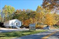
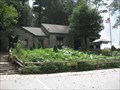
|   Harmony Church - Suches, Georgia Harmony Church - Suches, Georgia
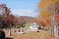
in Country Churches Harmony Church, a north Georgia mountain church, is located 2-miles east of Suches on highway 180, Wolf Pen Gap Road. posted by:  misfitt misfitt location: Georgia date approved: 02/11/2008 last visited: 05/29/2011 |
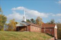 view gallery view gallery W1.8 km W1.8 km
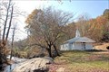
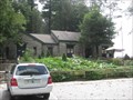
| Mt Lebanon Baptist Church- Suches Georgia in Country Churches Mt Lebanon Baptist Church, a north Georgia mountain church, is located on highway 180 about 1.25 miles east of Suches posted by: misfitt location: Georgia date approved: 02/03/2008 last visited: 05/29/2011 |
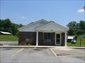 view gallery view galleryW2.7 km |  Suches, GA 30572 Suches, GA 30572
in U.S. Post Offices Small town Post Office. posted by: CM-14 location: Georgia date approved: 06/18/2007 last visited: 05/29/2011 |
 view gallery view galleryW2.7 km |  Davey's Bar-B-Que - Suches, GA Davey's Bar-B-Que - Suches, GA
in Classic BBQ and Sandwich Joints Roadside BBQ in Suches, GA. posted by: CM-14 location: Georgia date approved: 06/17/2007 last visited: 05/29/2011 |
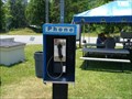 view gallery view galleryW2.7 km |  Payphone on the corner of GA60 and GA180 - Suches, GA Payphone on the corner of GA60 and GA180 - Suches, GA
in Payphones Payphone in Suches, GA. posted by: CM-14 location: Georgia date approved: 06/19/2007 last visited: 05/29/2011 |
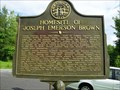 view gallery view galleryW2.9 km |  Homesite of Joseph Emerson Brown-GHM 144-6-Union Co Homesite of Joseph Emerson Brown-GHM 144-6-Union Co
in Georgia Historical Markers Ga 60 at the Woody Gap School, Suches posted by: Sprinterman location: Georgia date approved: 09/06/2009 last visited: 05/29/2011 |
 view gallery view gallery N3.4 km N3.4 km
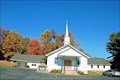
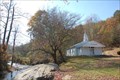
| Mt. Zion Baptist Church - Suches, Georgia in Country Churches Mt Zion Baptist Church, a north Georgia mountain church, is located 4-miles east of Suches on Highway 180, Wolf Pen Gap Road. posted by: misfitt location: Georgia date approved: 02/03/2008 last visited: 05/29/2011 |
 view gallery view gallery E5.3 km E5.3 km
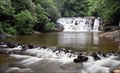
|  Dicks Creek Falls - Dahlonega, Georgia Dicks Creek Falls - Dahlonega, Georgia
in Waterfalls Dick's Creek Falls and the shoals above it are popular for wading and sunning in the summer posted by: Atlanta Highland Bagpiper location: Georgia date approved: 09/01/2016 last visited: never |
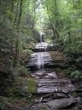 view gallery view galleryE7.1 km | DeSoto Falls - Cleveland, GA in Waterfalls Quick hike to a nice fall viewing platform posted by:  huntinkat huntinkat location: Georgia date approved: 05/11/2009 last visited: 04/21/2018 |
 view gallery view galleryW7.1 km | Mt. Pleasant Baptist Church (The Hill) - Gaddistown, Georgia in Country Churches Mt. Pleasant (The Hill) Baptist Church, a north Georgia mountain church is located just of highway 60 about 1.5 miles from Gaddistown. posted by: misfitt location: Georgia date approved: 01/17/2008 last visited: never |
 view gallery view galleryW7.7 km | Pleasant Valley Baptist Church - Gaddistown, Georgia in Country Churches Pleasant Valley Baptist Church is located right in Gaddistown on the Gaddistown Road about two miles off of highway Ga-60 posted by: misfitt location: Georgia date approved: 01/22/2008 last visited: never |
 view gallery view galleryW7.7 km |  Pleasant Valley Baptist Church - Gaddistown, GA, USA Pleasant Valley Baptist Church - Gaddistown, GA, USA
in Former Schools This church is located deep in the Blue Ridge mountains of north Georgia about 60-miles north of Atlanta. It is located on the Gaddistown Road at the junction of Canada Creek Road West. This is located about 1.5-miles south of highway 60. posted by: misfitt location: Georgia date approved: 04/23/2008 last visited: never |
 view gallery view gallery NE8 km NE8 km
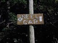
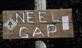
|  Neel's Gap, North GA - 3108 Neel's Gap, North GA - 3108
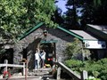
in Elevation Signs Mounted to a bolder at the entrance to the Walasi-yi Center, a stone building built in the 1930's by the Civilian Conservation Corps (CCC) at Neels Gap posted by: Lat34North location: Georgia date approved: 08/13/2010 last visited: 08/01/2020 |
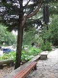
 view gallery view galleryNE8 km |  Walasi-Yi Inn - Blairsville, GA Walasi-Yi Inn - Blairsville, GA
in U.S. National Register of Historic Places Located conviently along the Appalichian Trail, they provide any gear you might need for your hike. Also serves as a information booth and hostel (yes, they have showers). Mke sure to check out the 'shoe collection'. posted by: ChapterhouseInc location: Georgia date approved: 08/24/2010 last visited: 08/01/2020 |
 view gallery view galleryNE8 km |  Walasi-Yi Interpretive Center - Neels Gap - Georgia Walasi-Yi Interpretive Center - Neels Gap - Georgia
in Wikipedia Entries Walasi-Yi (pronounced: Wa La See Yee) was built by the Civilian Conservation Corps beginning in 1934 and completed in 1937 and is located on US 19 in the mountains of North Georgia. posted by: Lat34North location: Georgia date approved: 10/14/2007 last visited: 08/01/2020 |
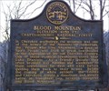 view gallery view galleryNE8 km | Blood Mountain in Georgia Historical Markers A marker at Neel's Gap on highway 19 between Blairsville and Cleveland, Georgia. posted by:  NevaP NevaP location: Georgia date approved: 02/13/2007 last visited: 08/01/2020 |
 view gallery view galleryNE8 km |  Mountain Crossings at Walasi-yi Mountain Crossings at Walasi-yi
in Outdoor Recreation Stores Located conviently along the Appalichian Trail, they provide any gear you might need for your hike. Also serves as a information booth and hostel (yes, they have showers). Mke sure to check out the 'shoe collection'. posted by: ChapterhouseInc location: Georgia date approved: 08/27/2010 last visited: 08/01/2020 |
 view gallery view galleryNE8 km |  Walasi-Yi - Neels Gap - North Georgia Walasi-Yi - Neels Gap - North Georgia
in Civilian Conservation Corps Walasi-Yi (pronounced: Wa La See Yee) was built by the Civilian Conservation Corps beginning in 1934 and completed in 1937 and is located on US 19 in the mountains of North Georgia. posted by: Lat34North location: Georgia date approved: 10/14/2007 last visited: 08/01/2020 |
 view gallery view galleryNE8 km |  Neels Gap - Georgia Neels Gap - Georgia
in Named Mountain Gaps Neels Gap is located in the Southern Appalachian Mountains of North Georgia. posted by: Lat34North location: Georgia date approved: 10/13/2007 last visited: 08/01/2020 |
 view gallery view galleryNE8 km |  AT at Walasi-Yi - Neel's Gap, North GA AT at Walasi-Yi - Neel's Gap, North GA
in Appalachian Trail Neel's Gap is located in the Southern Appalachian Mountains of North Georgia. The Walasi-yi Center, a stone building built in the 1930's by the Civilian Conservation Corps (CCC) is located at Neels Gap. posted by: Lat34North location: Georgia date approved: 11/09/2007 last visited: 08/01/2020 |
 view gallery view galleryNE8 km |  Walasi-Yi Shoe Tree Walasi-Yi Shoe Tree
in Shoe Trees Located conviently along the Appalichian Trail, they provide any gear you might need for your hike. Make sure to check out the 'shoe collection' donated by AT hikers. posted by: ChapterhouseInc location: Georgia date approved: 09/01/2010 last visited: 08/01/2020 |
 view gallery view gallery SE8.4 km SE8.4 km
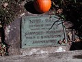
| Trahlyta's Grave - GHM 093-3 – Lumpkin Co., GA in Georgia Historical Markers This pile of stones marks the grave of a Cherokee princess, Trahlyta. According to legend her tribe, living on Cedar Mountain north of here, knew the secret of the magic springs of eternal youth from the Witch of Cedar Mountain. posted by: Lat34North location: Georgia date approved: 10/14/2007 last visited: 11/12/2015 |
 view gallery view gallerySE8.4 km |  Trahlyta's Grave Trahlyta's Grave
in Out of Place Graves An Indian princess is buried at the intersection of two highways in the north Georgia mountains. posted by: queenofthehill location: Georgia date approved: 08/09/2008 last visited: 11/12/2015 |
 view gallery view gallerySE8.4 km | Mt. Pisgah Baptist Church - Turners Corner, Georgia in Country Churches Mt. Pisgah Baptist, a north Georgia mountain Church, is located highway US-19 about .5-mile south of Turners Corner. posted by: misfitt location: Georgia date approved: 01/16/2008 last visited: 05/29/2011 |
 view gallery view gallerySE8.4 km | Mt. Pisgah School - Turners Corner, GA, USA in Former Schools Located on Dicks Creek Road, about .5-mile north of US-19 highway, about .5-mile south of US-129 at Turners Corner. posted by: misfitt location: Georgia date approved: 04/23/2008 last visited: 05/29/2011 |
|