 view gallery view gallery SE2.3 km SE2.3 km
|   Davis Wood Products Water Tower, Drake, SC, USA Davis Wood Products Water Tower, Drake, SC, USA
in Water Towers Nice surprise as I rounded the corner and saw this water tower at an abandoned work site. The former cotton gin repurposed for a pallet factory. posted by:  NCDaywalker NCDaywalker location: South Carolina date approved: 06/05/2017 last visited: 06/05/2017 |
 view gallery view gallery W3.2 km W3.2 km
| Mohawk Industries, Bennettsville, SC, USA in Water Towers The water tower is located on company property behind the manufacturing plant. posted by: NCDaywalker location: South Carolina date approved: 10/25/2018 last visited: 02/17/2019 |
 view gallery view galleryW3.4 km |  The Battle of Hunt's Bluff/Old River Road The Battle of Hunt's Bluff/Old River Road
in South Carolina Historical Markers An interesting marker in the middle of nowhere really! It has a different story on each side! posted by:  Mvillian Mvillian location: South Carolina date approved: 11/30/2008 last visited: 08/18/2009 |
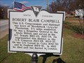 view gallery view gallery NE3.5 km NE3.5 km
| Robert Blair Campbell - John Campbell in South Carolina Historical Markers A favorite son of Blenheim community that served his country. Only fall ill while in the service of his country, die and be buried in London, England. posted by: NCDaywalker location: South Carolina date approved: 12/13/2015 last visited: 12/13/2015 |
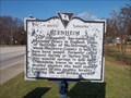 view gallery view galleryNE3.5 km | Blenheim, Blenheim, SC in South Carolina Historical Markers This marker celebrates the beginning of the community of Blenheim, SC. This is the home of Blenheim Ginger Ale. In my opinion, the best ginger ale I have ever consumed. posted by: NCDaywalker location: South Carolina date approved: 12/13/2015 last visited: 12/13/2015 |
 view gallery view galleryNE3.7 km |  Blenheim Vol Fire Dept Pumper/Tanker 773 Blenheim Vol Fire Dept Pumper/Tanker 773
in Fire Fighting Vehicles Blenheim Vol Fire Dept Tanker 773 provides water supply to areas in the district not served by the county water supply. posted by: NCDaywalker location: South Carolina date approved: 12/19/2015 last visited: 12/20/2015 |
 view gallery view galleryNE3.7 km |  Marlboro Rescue, Station 4, Blenheim, SC Marlboro Rescue, Station 4, Blenheim, SC
in Paramedic Stations Station 4 of the Marlboro Rescue Squad is located at intersection of E High St and SC 38, Blenheim, SC. Crew and equipment is housed at the Blenheim Vol. Fire Dept. posted by: NCDaywalker location: South Carolina date approved: 12/12/2015 last visited: 12/12/2015 |
 view gallery view galleryW3.7 km |  Thomas Marshall Blue Boat Ramp, near Bennettesville, SC Thomas Marshall Blue Boat Ramp, near Bennettesville, SC
in Boat Ramps SC Wildlife Resources Commission, Thomas Marshall Blue boat launch area is located on the Great Pee Dee River south of Bennettsville, SC. posted by: NCDaywalker location: South Carolina date approved: 08/24/2009 last visited: 06/21/2010 |
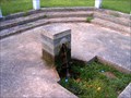 view gallery view galleryNE4 km |  Blenheim Mineral Springs - Blenheim, SC Blenheim Mineral Springs - Blenheim, SC
in Natural Springs Discovered in 1781, the Blenheim Springs provide natural flowing spring continually since. The Blenheim Ginger Ale bottling plant was located immediately next door and used water for their product until the plant burned down. posted by: NCDaywalker location: South Carolina date approved: 08/22/2009 last visited: 07/04/2011 |
 view gallery view gallery N6.8 km N6.8 km
| Marlboro Water Company, Water tower SC 38, Marlboro County in Water Towers The Marlboro Water Company supplies a great portion of water service to the residents of Marlboro County. posted by: NCDaywalker location: South Carolina date approved: 12/13/2015 last visited: 12/13/2015 |
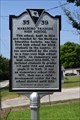
 view gallery view gallerySE7.2 km | Brownsville Baptist Church SCHM 35-30 in South Carolina Historical Markers Plaque by the church decribing the history of the church and congregation. posted by: NCDaywalker location: South Carolina date approved: 11/20/2016 last visited: 11/20/2016 |
 view gallery view gallery S7.6 km S7.6 km
| SCHM 35 29 Brownsville Church in South Carolina Historical Markers Another nice HM for a church in SC. posted by: NCDaywalker location: South Carolina date approved: 06/04/2017 last visited: 06/04/2017 |
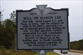 view gallery view gallerySE9.2 km | Grave of Mason Lee/Will of Mason Lee SCHM 35-21 in South Carolina Historical Markers Plaque is located at the intersection of SC 38 and Road 18 in the community of Bristow, SC. posted by: NCDaywalker location: South Carolina date approved: 11/20/2016 last visited: 11/21/2016 |
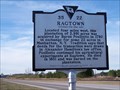 view gallery view gallerySE9.3 km | 35-22 FREDERRICK CHARLES HANS BRUNO POELLNITZ / RAGTOWN in South Carolina Historical Markers This is one of my favorite markers! It is located on Hwy 38 between Brownsville and Blenheim posted by: Mvillian location: South Carolina date approved: 03/27/2006 last visited: 09/16/2018 |
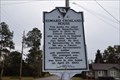
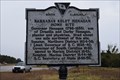 view gallery view gallerySE9.7 km | Barnabas Kelet Henagan Home Site SCHM 35-19 in South Carolina Historical Markers Located at the intersection of SC 38 and Road 18, in Bristow, SC, the plaque celebrates a local politician that rose the state's highest office as well as national level positions. posted by: NCDaywalker location: South Carolina date approved: 11/19/2016 last visited: 11/19/2016 |
 view gallery view galleryNE10.5 km |  Bell - St Matthews Missionary Baptist Church, near Clio, SC Bell - St Matthews Missionary Baptist Church, near Clio, SC
in Bells Church bell placed in a brick mount on the front lawn of St Matthews Missionary Baptist Church on state road SC 35-29, near Clio, SC. posted by: NCDaywalker location: South Carolina date approved: 08/22/2009 last visited: 06/21/2010 |
 view gallery view galleryN10.5 km | Marlboro Water Company, Water tower at main office, Marlboro County in Water Towers The Marlboro Water Company supplies a great portion of water service to the residents of Marlboro County. posted by: NCDaywalker location: South Carolina date approved: 12/13/2015 last visited: 12/13/2015 |
 view gallery view gallery NW12.7 km NW12.7 km
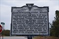
| Marlborough Court House/Old River Road SCHM 35-26 in South Carolina Historical Markers Plaque is double sided, located on US 401 and 15 at intersection of SC 912. posted by: NCDaywalker location: South Carolina date approved: 11/20/2016 last visited: 09/08/2018 |
 view gallery view galleryN12.7 km |  Regan Ave - Silo - Bennettsville, SC Regan Ave - Silo - Bennettsville, SC
in Solitary Silos This lone silo is located on Regan Ave in Bennettsville, SC. Street sign for the dirt road that the silo is located states the name is Regan Ave while Google Maps calls it S. Parsonage St. It is located near the SC National Guard Armory. posted by: NCDaywalker location: South Carolina date approved: 08/23/2009 last visited: 06/21/2010 |
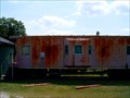 view gallery view galleryN13 km |  Caboose, Southern (SOU) X750. , motel room. Bennettsville, SC, Caboose, Southern (SOU) X750. , motel room. Bennettsville, SC,
in Train Cabooses This a caboose found in Bennettsville, SC. The property has a sign that states property is a motel. No name for motel is listed nor offered by those that gave permission to take the photos. posted by: NCDaywalker location: South Carolina date approved: 07/31/2009 last visited: 06/21/2010 |
 view gallery view galleryN13.4 km | 35-39 Marlboro Training High School in South Carolina Historical Markers Historical marker citing the importance of a school that served many who otherwise may not have received an education. posted by: NCDaywalker location: North Carolina date approved: 06/04/2017 last visited: 06/04/2017 |
 view gallery view galleryN13.5 km |  EB4100 35 016 EB4100 35 016
in U.S. Benchmarks The station is located adjacent to the marquee for the Greater Saint Luke Pentacostal Holiness Church. posted by: NCDaywalker location: South Carolina date approved: 01/30/2019 last visited: never |
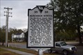
 view gallery view galleryN14 km | Edward Crosland House SCHM 35-3 in South Carolina Historical Markers The plaque is located at 204 Parsonage Street, Bennettsville. SC. posted by: NCDaywalker location: South Carolina date approved: 11/20/2016 last visited: 11/21/2016 |
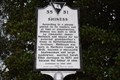 view gallery view galleryN14 km | Shiness SCHM 35-31 in South Carolina Historical Markers The plaque is located near downtown Bennettsville,SC , at 100 Fayetteville Avenue. posted by: NCDaywalker location: South Carolina date approved: 11/20/2016 last visited: 11/21/2016 |
 view gallery view galleryN14 km | Murchison School SCHM 35 35 in South Carolina Historical Markers At the corner of Fayetteville Ave. & S. Marlboro St.in Bennettsville, SC, one can find this plaque. posted by: NCDaywalker location: South Carolina date approved: 11/20/2016 last visited: 11/20/2016 |
|