 view gallery view gallery E3.9 km E3.9 km
|   Blue Cut - Cajon, CA Blue Cut - Cajon, CA
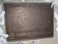
in LDS Church History Sites This was the end of the southern Mormon trail route from Salt Lake City in the early 1800's. posted by:  bluesnote bluesnote location: California date approved: 10/24/2014 last visited: 02/21/2018 |
 view gallery view galleryE3.9 km |  The Blue Cut Rte 66 History - Cajon, CA The Blue Cut Rte 66 History - Cajon, CA
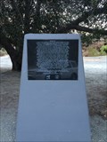
in Route 66 - The Mother Road This E Clampus Vitus and Route 66 Marker is located at what used to be a rest area along The Mother Road through Cajon Pass. posted by:  DopeyDuck DopeyDuck location: California date approved: 01/20/2009 last visited: 02/21/2018 |
 view gallery view galleryE3.9 km |  Blue Cut - Cajon, CA Blue Cut - Cajon, CA
in Wagon Roads and Trails This was the end of the southern Mormon trail route from Salt Lake City in the early 1800's. posted by: bluesnote location: California date approved: 10/26/2014 last visited: 02/21/2018 |
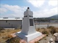
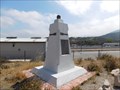
 view gallery view galleryE3.9 km |  The Blue Cut - Cajon, CA The Blue Cut - Cajon, CA
in E Clampus Vitus Historical Markers This E Clampus Vitus and Route 66 Marker is located at what used to be a rest area along The Mother Road through Cajon Pass. It was placed by the Billy Holcolmb Chapter on July 23, 1994. posted by: DopeyDuck location: California date approved: 01/20/2009 last visited: 05/08/2021 |
 view gallery view galleryE3.9 km |  Blue Cut - Historic Route 66 - Cajon Pass, CA Blue Cut - Historic Route 66 - Cajon Pass, CA
in National Scenic Byways This was the end of the southern Mormon trail route from Salt Lake City in the early 1800's. posted by: bluesnote location: California date approved: 03/29/2016 last visited: 02/21/2018 |
 view gallery view galleryE3.9 km |  Blue Cut - Cajon, CA, USA Blue Cut - Cajon, CA, USA
in Human Migration Monuments This was the end of the southern Mormon trail route from Salt Lake City in the early 1800's. posted by: bluesnote location: California date approved: 12/20/2014 last visited: 02/21/2018 |
 view gallery view gallery NE6.1 km NE6.1 km
|  Route 66 Directions - Phelan, CA Route 66 Directions - Phelan, CA
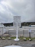
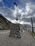
in Direction and Distance Arrows A direction and distance arrow display along Route 66 in the Cajon Pass. posted by: bluesnote location: California date approved: 02/21/2024 last visited: never |
 view gallery view galleryNE6.1 km | Route 66 Directions - Phelan, CA in Route 66 - The Mother Road A direction and distance arrow display along Route 66 in the Cajon Pass. posted by: bluesnote location: California date approved: 02/16/2024 last visited: never |
 view gallery view galleryNE6.1 km | Route 66 Directions - Historic Route 66 - Phelan, CA in National Scenic Byways A direction and distance arrow display along Route 66 in the Cajon Pass. posted by: bluesnote location: California date approved: 02/17/2024 last visited: never |
 view gallery view galleryNE6.1 km |  Sante Fe and Salt Lake Trail Monument - San Bernardino, CA Sante Fe and Salt Lake Trail Monument - San Bernardino, CA
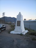
in California Historical Markers California Historical Marker #576 posted by: DopeyDuck location: California date approved: 10/04/2008 last visited: 11/18/2013 |
 view gallery view galleryNE6.1 km | Santa Fe and Salt Lake Trail - Cajon Pass, CA in Route 66 - The Mother Road Located on Route 66, this monument recognizes some of the first pioneers that used the Santa Fe and Salt Lake Trail, which crosses Route 66 right here. posted by: bluesnote location: California date approved: 03/14/2012 last visited: 11/02/2013 |
 view gallery view galleryNE6.1 km | Santa Fe and Salt Lake Trail - Cajon Pass, CA in Wagon Roads and Trails Located on Route 66, this monument recognizes some of the first pioneers that used the Santa Fe and Salt Lake Trail, which crosses Route 66 right here. posted by: bluesnote location: California date approved: 06/01/2015 last visited: 06/01/2015 |
 view gallery view galleryNE6.1 km | Santa Fe and Salt Lake Trail - Historic Route 66 - Cajon Pass, CA in National Scenic Byways Located on Route 66, this monument recognizes some of the first pioneers that used the Santa Fe and Salt Lake Trail, which crosses Route 66 right here. posted by: bluesnote location: California date approved: 03/29/2016 last visited: 03/29/2016 |
 view gallery view galleryNE6.1 km | Santa Fe and Salt Lake Trail - Cajon Pass, CA, USA in Human Migration Monuments Located on Route 66, this monument recognizes some of the first pioneers that used the Santa Fe and Salt Lake Trail, which crosses Route 66 right here. posted by: bluesnote location: California date approved: 05/26/2015 last visited: 05/26/2015 |
 view gallery view galleryNE6.1 km | Camp Cajon - Historic Route 66 - Phelan, CA in National Scenic Byways A large monument in Phelan, California. posted by: bluesnote location: California date approved: 02/10/2024 last visited: never |
 view gallery view galleryNE6.1 km |  Camp Cajon - Phelan, CA Camp Cajon - Phelan, CA
in Ghost Towns A large monument in Phelan, California. posted by: bluesnote location: California date approved: 02/14/2024 last visited: never |
 view gallery view galleryNE6.1 km | Camp Cajon - Phelan, CA in Route 66 - The Mother Road A large monument in Phelan, California. posted by: bluesnote location: California date approved: 02/09/2024 last visited: never |
 view gallery view galleryNE6.1 km | Cajon Pass - Phelan, CA in Route 66 - The Mother Road The main artery connecting the Inland Empire and the high desert. The Cajon Pass was formed by the San Andreas fault and is the transition between the San Gabriel and San Bernardino mountains. It carries major routes including US 66, US 395 and I-15. posted by: bluesnote location: California date approved: 02/11/2024 last visited: never |
 view gallery view galleryNE6.1 km |  Cajon Pass - Phelan, CA Cajon Pass - Phelan, CA
in Named Mountain Gaps The main artery connecting the Inland Empire and the high desert. The Cajon Pass was formed by the San Andreas fault and is the transition between the San Gabriel and San Bernardino mountains. It carries major routes including US 66, US 395 and I-15. posted by: bluesnote location: California date approved: 02/17/2024 last visited: never |
 view gallery view galleryNE6.1 km |  Cajon Pass - Phelan, CA Cajon Pass - Phelan, CA
in Wikipedia Entries The main artery connecting the Inland Empire and the high desert. The Cajon Pass was formed by the San Andreas fault and is the transition between the San Gabriel and San Bernardino mountains. It carries major routes including US 66, US 395 and I-15. posted by: bluesnote location: California date approved: 02/08/2024 last visited: never |
 view gallery view galleryNE6.1 km | Cajon Pass - Historic Route 66 - Phelan, CA in National Scenic Byways The main artery connecting the Inland Empire and the high desert. The Cajon Pass was formed by the San Andreas fault and is the transition between the San Gabriel and San Bernardino mountains. It carries major routes including US 66, US 395 and I-15. posted by: bluesnote location: California date approved: 02/24/2024 last visited: never |
 view gallery view galleryNE6.1 km |  Camp Cajon - Phelan, CA ~ Elevation 3002 ft. Camp Cajon - Phelan, CA ~ Elevation 3002 ft.
in Elevation Signs A large monument in Phelan, California. posted by: bluesnote location: California date approved: 02/10/2024 last visited: never |
 view gallery view galleryNE6.1 km | Camp Cajon - Phelan, CA in Human Migration Monuments A large monument in Phelan, California. posted by: bluesnote location: California date approved: 05/04/2024 last visited: never |
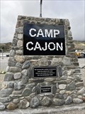 view gallery view galleryNE6.1 km |  Camp Cajon - Phelan, CA Camp Cajon - Phelan, CA
in Cairns A large monument in Phelan, California. posted by: bluesnote location: California date approved: 02/08/2024 last visited: never |
 view gallery view galleryNE6.1 km |  Cajon Pass - Phelan, CA Cajon Pass - Phelan, CA
in Satellite Imagery Oddities The main artery connecting the Inland Empire and the high desert. The Cajon Pass was formed by the San Andreas fault and is the transition between the San Gabriel and San Bernardino mountains. It carries major routes including US 66, US 395 and I-15. posted by: bluesnote location: California date approved: 02/08/2024 last visited: never |
|