 view gallery view gallery S13.8 km S13.8 km
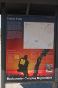
|   Turkey Flats Trailhead - Joshua Tree National Park Turkey Flats Trailhead - Joshua Tree National Park
in Hiking and walking trailheads This is the trailhead for the Turkey Flat trail located in the Joshua Tree National Park. This trail is a loop trail that leads up to the summit of Pinto Mountain and back again. posted by:  geobwong2k geobwong2k location: California date approved: 03/25/2009 last visited: 01/03/2014 |
 view gallery view gallery SW15.8 km SW15.8 km
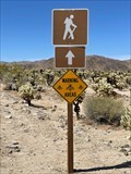
|  Watch out for Bees or Wasps- Joshua Tree Watch out for Bees or Wasps- Joshua Tree
in Uncommon Crossing Signs By the Cholla Cactus Garden in Joshua Tree is this warning sign to watch out for bees or wasps. posted by:  funsigns funsigns location: California date approved: 04/19/2021 last visited: 04/27/2022 |
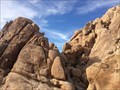
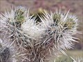 view gallery view gallerySW15.8 km |  Cholla Cactus Garden - Joshua Tree National Park Cholla Cactus Garden - Joshua Tree National Park
in National Parks of the World One of the highlights of Joshua Tree NP posted by: Bernd das Brot Team location: California date approved: 06/24/2008 last visited: 04/27/2022 |
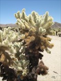 view gallery view gallerySW15.8 km |  Cholla Cactus Garden - Joshua Tree, CA Cholla Cactus Garden - Joshua Tree, CA
in Self Guided Walks and Trails The Cholla Cactus Garden has a self-guided trail that explains the variety of cactus and wildlife in the area. posted by: Gryffindor3 location: California date approved: 06/09/2009 last visited: 04/27/2022 |
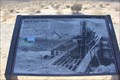 view gallery view gallerySW17.9 km |  Silver Bell Mine Silver Bell Mine
in Mines The Silver Bell Mine is the most obvious mine in the park, with two ore bins clearly visible from milepost 8 on the Pinto Basin Road. posted by: C&SL location: California date approved: 01/06/2014 last visited: never |
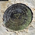 view gallery view gallery W18 km W18 km
|  Belle2 - Joshua Tree National Park Belle2 - Joshua Tree National Park
in U.S. Benchmarks USCGS triangulation station located near microwave tower on mountain top east of Belle Campground, JTNP. posted by: macpurity location: California date approved: 08/29/2012 last visited: never |
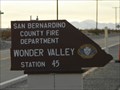 view gallery view gallery NW18.2 km NW18.2 km
|  San Bernardino County Fire Department - Wonder Valley - Station 45 San Bernardino County Fire Department - Wonder Valley - Station 45
in Firehouses This firehouse is on Amboy Rd, 6 miles west of Twentynine Palms, California. posted by: PeterNoG location: California date approved: 01/03/2011 last visited: 01/01/2011 |
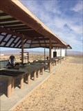 view gallery view galleryNW18.5 km |  Twenty-nine Palms Shooting Range - Twenty-nine Palms, CA Twenty-nine Palms Shooting Range - Twenty-nine Palms, CA
in Shooting Ranges An outdoor shooting range in Twenty-nine Palms. posted by: bluesnote location: California date approved: 03/09/2018 last visited: 03/09/2018 |
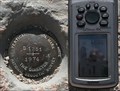 view gallery view galleryW19.8 km | DX3350: S 1251 - Joshua Tree National Park CA in U.S. Benchmarks This Benchmark is 135 feet southwest of Pinto Basin Road and El Dorado Mine Road in Joshua Tree National Park, California. It's about 30 feet west of the parking lot. posted by: PeterNoG location: California date approved: 09/22/2013 last visited: 12/19/2022 |
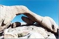 view gallery view galleryW19.8 km | Joshua Tree National Park - Arch Rock in National Parks of the World This natural arch is located along a well posted geologic nature trail that starts in the White Tank Campground. The trail ranges from loose sand to hard rock with steps. There are great signs posted along the trail with additional geologic information about the area. posted by: TerryDad2 location: California date approved: 08/24/2006 last visited: 08/03/2020 |
 view gallery view galleryW19.8 km |  Joshua Tree National Park - Arch Rock Joshua Tree National Park - Arch Rock
in Natural Arches This natural arch is located along a well posted geologic nature trail that starts in the White Tank Campground. The trail ranges from loose sand to hard rock with steps. There are great signs posted along the trail with additional geologic information about the area. posted by: TerryDad2 location: California date approved: 08/24/2006 last visited: 11/04/2017 |
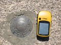
 view gallery view galleryW20 km | BM383442 - Joshua Tree, CA in U.S. Benchmarks This benchmark is along the nature trail leading to Arch Rock. posted by: Gryffindor3 location: California date approved: 05/27/2009 last visited: never |
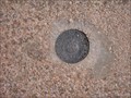
 view gallery view galleryW20.1 km | EV0305-Joshua Tree National Park in U.S. Benchmarks This is a benchmark disk found in monzogranite near Belle Campground in Joshua Tree National park. posted by: yoyo ken location: California date approved: 06/09/2009 last visited: 11/01/2015 |
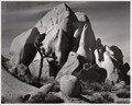 view gallery view galleryW22 km |  Joshua Tree Joshua Tree
in Ansel Adams Photo Hunt Site of 1942 Adams photo of a rock formation at Joshua Tree National Park. posted by: ddrundle location: California date approved: 09/14/2013 last visited: 02/04/2014 |
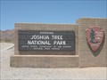
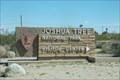
 view gallery view galleryW22 km | Joshua Tree National Park, California in National Parks of the World The Main Entrance to the Joshua Tree National Park. posted by: geobwong2k location: California date approved: 03/17/2008 last visited: 04/27/2022 |
 view gallery view galleryW22 km |  Joshua Tree National Park, America's National Parks Edition Joshua Tree National Park, America's National Parks Edition
in Monopoly in the Real World Joshua Tree National Park is one of the Orange Properties in the America's National Parks Edition. posted by: geobwong2k location: California date approved: 03/17/2008 last visited: 03/03/2022 |
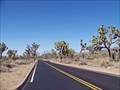 view gallery view galleryW22 km |  Joshua Tree National Park Scenic Byway Joshua Tree National Park Scenic Byway
in National Scenic Byways A 65 miles drive across Joshua Tree National Park posted by: Bernd das Brot Team location: California date approved: 07/27/2008 last visited: 03/03/2022 |
 view gallery view galleryW22.2 km |  Joshua Tree National Park - Joshua Tree, CA Joshua Tree National Park - Joshua Tree, CA
in Official Local Tourism Attractions One of a few national parks within California. posted by: bluesnote location: California date approved: 03/09/2018 last visited: 04/27/2022 |
 view gallery view galleryW22.2 km |  Joshua Tree National Park - Joshua Tree, CA Joshua Tree National Park - Joshua Tree, CA
in Wikipedia Entries Joshua Tree National Park is a large wilderness park with some spots available for outdoor activities. posted by: Gryffindor3 location: California date approved: 12/08/2009 last visited: 04/27/2022 |
 view gallery view galleryW22.2 km |  Joshua Tree National Park - Joshua Tree, CA Joshua Tree National Park - Joshua Tree, CA
in Bookcrossing Zones One of a few national parks within California. posted by: bluesnote location: California date approved: 06/04/2018 last visited: 04/27/2022 |
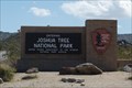 view gallery view galleryW22.2 km | ") Joshua Tree National Park, California Joshua Tree National Park, California
in National Parks (U.S.) The Main Entrance to the Joshua Tree National Park. posted by: geobwong2k location: California date approved: 03/17/2008 last visited: 04/27/2022 |
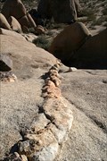 view gallery view galleryW23.3 km |  Aplites, Pegmatites, and Dikes…. Oh My!! Aplites, Pegmatites, and Dikes…. Oh My!!
in Places of Geologic Significance The monzogranites of Joshua Tree are commonly cut by linear cracks that are filled with a different material. This location has three examples of the types of rocks that fill these cracks. posted by: TerryDad2 location: California date approved: 01/24/2010 last visited: 07/04/2019 |
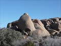
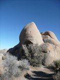 view gallery view galleryW23.7 km |  Skull Rock - Joshua Tree Natl Park Skull Rock - Joshua Tree Natl Park
in Simulacra Located along the main east-west park road, Skull Rock is a favorite stop for park visitors. A parking spot is located just across the road from the rock. posted by: PeterNoG location: California date approved: 02/19/2008 last visited: 04/27/2022 |
 view gallery view galleryW23.7 km |  Skull Rock - Sunday Strip - Joshua Tree Natl Park CA Skull Rock - Sunday Strip - Joshua Tree Natl Park CA
in Zippy the Pinhead Locations Zippy communed with nature at Skull Rock. It's located along the main east-west park road in Joshua Tree National Park near Twentynine Palms, California. posted by: PeterNoG location: California date approved: 11/22/2010 last visited: 04/27/2022 |
 view gallery view galleryNW24.3 km |  Joshua Tree National Park - Oasis Visitor Center - California Joshua Tree National Park - Oasis Visitor Center - California
in Ranger Stations The Oasis Visitor Center at the Joshua Tree National Park is the main visitor center for the park as well as the administrative offices. posted by: geobwong2k location: California date approved: 03/17/2008 last visited: 03/03/2022 |
|