 view gallery view gallery NE6.3 km NE6.3 km
|   USS Scorpion (SS – 278) - Bobby Brown State Park Elberton, GA USS Scorpion (SS – 278) - Bobby Brown State Park Elberton, GA
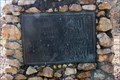
in Specific Veteran Memorials Dedicated to the crew of the USS Scorpion (SS-278), lost while on patrol in the East China Sea, April 1, 1944. Located on Bobby Brown Park Road at the Bobby Brown State Park. (Fee area) posted by:  Lat34North Lat34North location: Georgia date approved: 03/02/2010 last visited: 02/20/2010 |
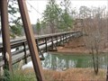 view gallery view galleryNE6.6 km |  Bobby Brown State Park Suspension Bridge Bobby Brown State Park Suspension Bridge
in Pedestrian Suspension Bridges Bobby Brown State Park Suspension Bridge, Elbert County Georgia. posted by:  OXCACHER OXCACHER location: Georgia date approved: 01/12/2007 last visited: never |
 view gallery view gallery W7.2 km W7.2 km
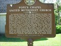
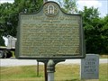
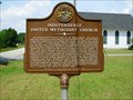
|  Pope's Chapel United Methodist Church-TUMC-Wilkes Co Pope's Chapel United Methodist Church-TUMC-Wilkes Co
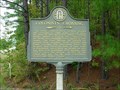
in Georgia Historical Markers Pope Chapel Road 3.2 mi N of Tignall on Ga 17, then R 3.8 mi, then R 0.2 posted by: Sprinterman location: Georgia date approved: 10/31/2009 last visited: 10/10/2009 |
 view gallery view gallery NW8.2 km NW8.2 km
|  Cades Chapel Baptist Church cemetery - Elberton, GA Cades Chapel Baptist Church cemetery - Elberton, GA
in Worldwide Cemeteries Cades Chapel Baptist Church cemetery is located at 3860 River Road, Elberton, GA. There are 500 to 600 headstones in the cemetery. posted by: Lat34North location: Georgia date approved: 03/02/2010 last visited: 02/20/2010 |
 view gallery view gallery N10.6 km N10.6 km
| Tates Grove Cemetery - Elberton, GA in Worldwide Cemeteries Tates Grove Cemetery is located on Bobby Brown State Park Road north of Russell Dam Road. There are 100 to 200 headstones in the cemetery. posted by: Lat34North location: Georgia date approved: 03/02/2010 last visited: 02/20/2010 |
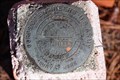 view gallery view galleryN10.8 km |  U.S. Army Corp of Engineers – G0009 – Lake Hartwell, Elberton, GA. U.S. Army Corp of Engineers – G0009 – Lake Hartwell, Elberton, GA.
in U.S. Benchmarks U.S. Army Corp of Engineers – G0009 located north of the Tates Grove Cemetery on the east side of Bobby Brown State Park Road, Elberton, GA. posted by: Lat34North location: Georgia date approved: 03/05/2010 last visited: 02/20/2010 |
 view gallery view gallery SW12.1 km SW12.1 km
| First Court North of Augusta-GHM 157-17-Wilkes Co in Georgia Historical Markers Ga 44 at Sandtown Road posted by: Sprinterman location: Georgia date approved: 07/15/2009 last visited: 07/17/2009 |
 view gallery view gallerySW12.1 km | Fishing Creek Baptist Church-GHM 157-26-Wilkes Co in Georgia Historical Markers About 1/4 mile west of Ga 44 on Sandtown Rd posted by: Sprinterman location: Georgia date approved: 07/15/2009 last visited: 10/18/2015 |
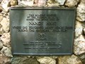 view gallery view galleryNW12.9 km |  Nancy Hart Cabin Nancy Hart Cabin
in Signs of History Located off Ga 17 in Nancy Hart Park on the cabin posted by: Markerman62 location: Georgia date approved: 08/06/2012 last visited: 07/25/2012 |
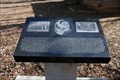
 view gallery view galleryNW12.9 km | Nancy Hart's Cabin - Elbert Co., GA in Georgia Historical Markers This historic marker to Nancy hart is located next to the replica of the Hart Cabin in the Nancy Hart State Park on River Road. posted by: Lat34North location: Georgia date approved: 02/25/2010 last visited: 07/25/2012 |
 view gallery view galleryNW12.9 km |  Hart Cabin - Elberton, GA Hart Cabin - Elberton, GA
in Homesteads Nancy Morgan Hart (c. 1735 – 1830) was a heroine of the American Revolutionary War. A replica of the cabin she and her family lived in is at the site of the historic homestead at Nancy Hart State Historical Site on River Road, Elberton, GA. posted by: Lat34North location: Georgia date approved: 06/30/2010 last visited: 07/25/2012 |
 view gallery view galleryNW12.9 km | Nancy Hart Spring - WPA - Elbert Co., GA in Georgia Historical Markers This marker WPA is located in the Nancy Hart State Park on River Road. posted by: Lat34North location: Georgia date approved: 02/25/2010 last visited: 07/25/2012 |
 view gallery view gallerySW12.9 km | Independence United Methodist Church-Wilkes Co in Georgia Historical Markers At church in Tignall (just west of Ga 17) posted by: Sprinterman location: Georgia date approved: 07/15/2009 last visited: 07/11/2009 |
 view gallery view gallerySW13.5 km | Heard's Fort (Early Georgia Capital)-GHM 157-16-Wilkes Co in Georgia Historical Markers Ga 44 at Mile Marker 20, about 1 mile south of Sandtown posted by: Sprinterman location: Georgia date approved: 07/16/2009 last visited: 07/17/2009 |
 view gallery view galleryNE13.7 km |  Little River Volunteer Fire Dept. Station 60 Little River Volunteer Fire Dept. Station 60
in Firehouses Located on Highway 81 in Mt.Carmel South Carolina. posted by: Firefrog69 location: South Carolina date approved: 12/21/2008 last visited: 02/11/2009 |
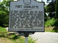 view gallery view galleryNE13.8 km |  Fort Charlotte-SCHM 33-1-McCormick Co Fort Charlotte-SCHM 33-1-McCormick Co
in South Carolina Historical Markers Intersection of SC 81 and Road 91 in Mt. Carmel posted by: Sprinterman location: South Carolina date approved: 07/07/2009 last visited: 07/04/2009 |
 view gallery view galleryN14.5 km | Colonist's Crossing-GHM 052-8A-Elbert Co in Georgia Historical Markers Ga 72 about 1 mile west of the Savannah River posted by: Sprinterman location: Georgia date approved: 10/31/2009 last visited: 02/20/2010 |
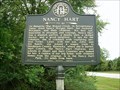 view gallery view galleryNW15 km | Nancy Hart -- GHM 052-9 -- Elbert Co in Georgia Historical Markers Ga 17 at River Road, about 10 miles south of Elberton posted by: Sprinterman location: Georgia date approved: 10/31/2009 last visited: 07/25/2012 |
 view gallery view galleryN15.4 km | Fleming Cemetery - Elberton, GA in Worldwide Cemeteries The Fleming Cemetery is located on Cut-Through Rd at Welcome Church Road, Elberton, GA. There are between 100 and 200 headstones in the cemetery. posted by: Lat34North location: Georgia date approved: 04/27/2010 last visited: 02/20/2010 |
 view gallery view galleryN15.4 km | Millwood in South Carolina Historical Markers Marker is in Calhoun Falls, South Carolina, in Abbeville County. Marker is on Calhoun Falls Highway (State Highway 72), on the right when traveling west. Marker is directly across Highway 72 from the Olin D. Johnston marker. The Millwood Marker is about 35 feet off the road in a grove of trees posted by: mr.volkswagen location: South Carolina date approved: 09/08/2010 last visited: never |
 view gallery view gallery E15.4 km E15.4 km
| Nobel Cemetery / Cherry Hill -SCHM 33-11-2 Sided Marker-McCormick County in South Carolina Historical Markers Intersection of SC 81 and Road 60, Willington posted by: Sprinterman location: South Carolina date approved: 07/07/2009 last visited: 07/04/2009 |
 view gallery view galleryE15.4 km | Willington Academy-SCHM 33-2-McCormick Co in South Carolina Historical Markers Intersection of SC 81 and Road 60, Willington posted by: Sprinterman location: South Carolina date approved: 07/07/2009 last visited: 07/04/2009 |
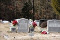
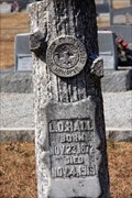 view gallery view galleryN15.4 km |  L. D. Hall - Bethlehem Methodist Church cemetery – Elberton, GA L. D. Hall - Bethlehem Methodist Church cemetery – Elberton, GA
in Woodmen of the World Grave Markers/Monuments Bethlehem Methodist Church cemetery is located at the church on Welcome Church Road, Elberton, GA. posted by: Lat34North location: Georgia date approved: 04/27/2010 last visited: 02/20/2010 |
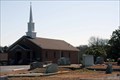 view gallery view galleryN15.4 km |  Bethlehem Methodist Church cemetery – Elberton, GA Bethlehem Methodist Church cemetery – Elberton, GA
in Churchyard Cemeteries Bethlehem Methodist Church cemetery is located at the church on Welcome Church Road, Elberton, GA. There are 400 to 500 headstones. posted by: Lat34North location: Georgia date approved: 04/30/2010 last visited: 01/20/2010 |
 view gallery view galleryN15.4 km | Bethlehem Methodist Church cemetery – Elberton, GA in Worldwide Cemeteries Bethlehem Methodist Church cemetery is located at the church on Welcome Church Road, Elberton, GA. There are 400 to 500 headstones. posted by: Lat34North location: Georgia date approved: 04/27/2010 last visited: 02/20/2010 |
|