 view gallery view gallery NE7.1 km NE7.1 km
|   DX3350: S 1251 - Joshua Tree National Park CA DX3350: S 1251 - Joshua Tree National Park CA
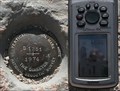
in U.S. Benchmarks This Benchmark is 135 feet southwest of Pinto Basin Road and El Dorado Mine Road in Joshua Tree National Park, California. It's about 30 feet west of the parking lot. posted by:  PeterNoG PeterNoG location: California date approved: 09/22/2013 last visited: 12/19/2022 |
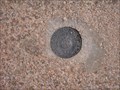 view gallery view galleryNE7.4 km | BM383442 - Joshua Tree, CA in U.S. Benchmarks This benchmark is along the nature trail leading to Arch Rock. posted by: Gryffindor3 location: California date approved: 05/27/2009 last visited: never |
 view gallery view gallery NW7.6 km NW7.6 km
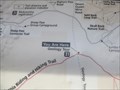
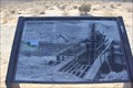
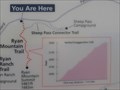
|  'You Are Here' Geology Tour Road - Joshua Tree Nat'l Park 'You Are Here' Geology Tour Road - Joshua Tree Nat'l Park
in 'You Are Here' Maps This 'You Are Here' Map is Geology Tour Road about 1.5 miles south of Park Boulevard in Joshua Tree National Park, California. posted by: PeterNoG location: California date approved: 03/05/2013 last visited: 02/04/2014 |
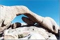
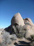
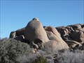
 view gallery view galleryNE7.6 km |  Joshua Tree National Park - Arch Rock Joshua Tree National Park - Arch Rock
in Natural Arches This natural arch is located along a well posted geologic nature trail that starts in the White Tank Campground. The trail ranges from loose sand to hard rock with steps. There are great signs posted along the trail with additional geologic information about the area. posted by: TerryDad2 location: California date approved: 08/24/2006 last visited: 11/04/2017 |
 view gallery view galleryNE7.6 km |  Joshua Tree National Park - Arch Rock Joshua Tree National Park - Arch Rock
in National Parks of the World This natural arch is located along a well posted geologic nature trail that starts in the White Tank Campground. The trail ranges from loose sand to hard rock with steps. There are great signs posted along the trail with additional geologic information about the area. posted by: TerryDad2 location: California date approved: 08/24/2006 last visited: 08/03/2020 |
 view gallery view gallery E8.2 km E8.2 km
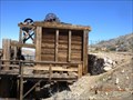
|  Silver Bell Mine Silver Bell Mine
in Mines The Silver Bell Mine is the most obvious mine in the park, with two ore bins clearly visible from milepost 8 on the Pinto Basin Road. posted by: C&SL location: California date approved: 01/06/2014 last visited: never |
 view gallery view gallery N8.2 km N8.2 km
|  Skull Rock - Joshua Tree Natl Park Skull Rock - Joshua Tree Natl Park
in Simulacra Located along the main east-west park road, Skull Rock is a favorite stop for park visitors. A parking spot is located just across the road from the rock. posted by: PeterNoG location: California date approved: 02/19/2008 last visited: 04/27/2022 |
 view gallery view galleryN8.2 km |  Skull Rock - Sunday Strip - Joshua Tree Natl Park CA Skull Rock - Sunday Strip - Joshua Tree Natl Park CA
in Zippy the Pinhead Locations Zippy communed with nature at Skull Rock. It's located along the main east-west park road in Joshua Tree National Park near Twentynine Palms, California. posted by: PeterNoG location: California date approved: 11/22/2010 last visited: 04/27/2022 |
 view gallery view gallery W8.4 km W8.4 km
| The Lost Horse Mine, Joshua Tree National Park in Mines One of several abandoned mines in Joshua Tree National park. posted by: toponym location: California date approved: 04/12/2010 last visited: 01/13/2011 |
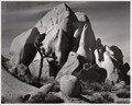 view gallery view galleryN8.5 km |  Joshua Tree Joshua Tree
in Ansel Adams Photo Hunt Site of 1942 Adams photo of a rock formation at Joshua Tree National Park. posted by:  ddrundle ddrundle location: California date approved: 09/14/2013 last visited: 02/04/2014 |
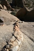 view gallery view galleryN8.7 km |  Aplites, Pegmatites, and Dikes…. Oh My!! Aplites, Pegmatites, and Dikes…. Oh My!!
in Places of Geologic Significance The monzogranites of Joshua Tree are commonly cut by linear cracks that are filled with a different material. This location has three examples of the types of rocks that fill these cracks. posted by: TerryDad2 location: California date approved: 01/24/2010 last visited: 07/04/2019 |
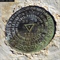
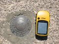 view gallery view galleryN9 km | EV0305-Joshua Tree National Park in U.S. Benchmarks This is a benchmark disk found in monzogranite near Belle Campground in Joshua Tree National park. posted by: yoyo ken location: California date approved: 06/09/2009 last visited: 11/01/2015 |
 view gallery view galleryN9.7 km |  Geological Trail - Joshua Tree National Park Geological Trail - Joshua Tree National Park
in Offroad Trails An 18-mile road leads through one of Joshua Tree National Park’s most fascinating landscapes. posted by: Go Boilers! location: California date approved: 04/05/2011 last visited: 02/04/2014 |
 view gallery view galleryNE9.8 km | Belle2 - Joshua Tree National Park in U.S. Benchmarks USCGS triangulation station located near microwave tower on mountain top east of Belle Campground, JTNP. posted by: macpurity location: California date approved: 08/29/2012 last visited: never |
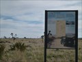
 view gallery view galleryW10.6 km | Lost Horse Mine Trail You Are Here sign in 'You Are Here' Maps You Are Here sign at the Lost Horse Mine trailhead. posted by: toponym location: California date approved: 04/11/2010 last visited: 01/13/2011 |
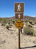 view gallery view galleryE10.9 km |  Watch out for Bees or Wasps- Joshua Tree Watch out for Bees or Wasps- Joshua Tree
in Uncommon Crossing Signs By the Cholla Cactus Garden in Joshua Tree is this warning sign to watch out for bees or wasps. posted by: funsigns location: California date approved: 04/19/2021 last visited: 04/27/2022 |
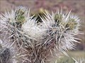 view gallery view galleryE10.9 km | Cholla Cactus Garden - Joshua Tree National Park in National Parks of the World One of the highlights of Joshua Tree NP posted by: Bernd das Brot Team location: California date approved: 06/24/2008 last visited: 04/27/2022 |
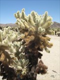 view gallery view galleryE10.9 km |  Cholla Cactus Garden - Joshua Tree, CA Cholla Cactus Garden - Joshua Tree, CA
in Self Guided Walks and Trails The Cholla Cactus Garden has a self-guided trail that explains the variety of cactus and wildlife in the area. posted by: Gryffindor3 location: California date approved: 06/09/2009 last visited: 04/27/2022 |
 view gallery view galleryNW11.9 km | Ryan Mountain Trail, Joshua Tree NP, You are here in 'You Are Here' Maps A map at the trailhead of the Ryan Mountain Trail in Joshua Tree National Park. posted by: PeterNoG location: California date approved: 01/28/2011 last visited: 01/06/2011 |
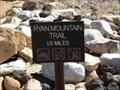 view gallery view galleryNW11.9 km |  Ryan Mountain Trail Ryan Mountain Trail
in Hiking and walking trailheads A 1.5 mile hike to the peak of Mt. Ryan in Joshua Tree National Park. posted by: toponym location: California date approved: 03/16/2010 last visited: 01/10/2015 |
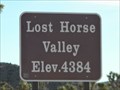 view gallery view galleryNW12.2 km |  Lost Horse Valley, Joshua Tree National Park - 4384 ft Lost Horse Valley, Joshua Tree National Park - 4384 ft
in Elevation Signs This elevation sign is on Keys View Rd which goes to Keys View, the highest point in Joshua Tree National Park. The sign is just over a mile south of Park Boulevard. posted by: PeterNoG location: California date approved: 01/21/2011 last visited: 01/03/2014 |
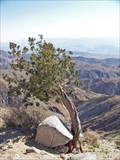 view gallery view galleryW12.9 km |  Keys View, Joshua Tree National Park Keys View, Joshua Tree National Park
in Scenic Overlooks top of the Little San Bernardino Mountains posted by: Bernd das Brot Team location: California date approved: 06/28/2008 last visited: 02/04/2014 |
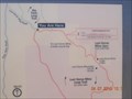
 view gallery view galleryW12.9 km | San Andreas Fault You Are Here map in 'You Are Here' Maps You are here map overlooking the San Andreas Fault. posted by: toponym location: California date approved: 04/11/2010 last visited: 02/04/2014 |
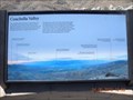 view gallery view galleryW12.9 km |  Keys View Orientation Table, Joshua Tree National Park Keys View Orientation Table, Joshua Tree National Park
in Orientation Tables Orientation table of the Coachella Valley. posted by: toponym location: California date approved: 04/12/2010 last visited: 11/11/2021 |
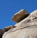 view gallery view galleryNW12.9 km |  Hidden Valley - Joshua Tree NP Hidden Valley - Joshua Tree NP
in Nature's Balanced Rocks Rest Area near Hidden Valley in Joshua Tree National Park posted by: Bernd das Brot Team location: California date approved: 06/24/2008 last visited: 12/21/2014 |
|