 view gallery view gallery E6.1 km E6.1 km
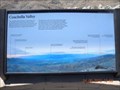
|   Keys View Orientation Table, Joshua Tree National Park Keys View Orientation Table, Joshua Tree National Park
in Orientation Tables Orientation table of the Coachella Valley. posted by:  toponym toponym location: California date approved: 04/12/2010 last visited: 11/11/2021 |
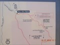
 view gallery view galleryE6.1 km |  San Andreas Fault You Are Here map San Andreas Fault You Are Here map
in 'You Are Here' Maps You are here map overlooking the San Andreas Fault. posted by: toponym location: California date approved: 04/11/2010 last visited: 02/04/2014 |
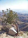 view gallery view galleryE6.3 km |  Keys View, Joshua Tree National Park Keys View, Joshua Tree National Park
in Scenic Overlooks top of the Little San Bernardino Mountains posted by:  Bernd das Brot Team Bernd das Brot Team location: California date approved: 06/28/2008 last visited: 02/04/2014 |
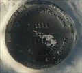
 view gallery view gallery SW6.4 km SW6.4 km
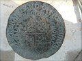
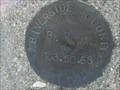
|  DX0097: T3S R6 7E SECS 25 30 31 36 - Sky Valley CA DX0097: T3S R6 7E SECS 25 30 31 36 - Sky Valley CA
in U.S. Benchmarks This Benchmark is about 290 feet SSE of the corner of 1000 Palms Canyon Road and Dillon Road near Sky Valley, California. posted by: PeterNoG location: California date approved: 09/18/2013 last visited: 12/18/2020 |
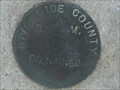
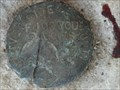
 view gallery view gallerySW6.4 km |  T3S R6E 7E SECS 25 30 31 36 COR - Sky Valley CA T3S R6E 7E SECS 25 30 31 36 COR - Sky Valley CA
in Public Land Survey Marks This Public Land Survey Mark is about 290 feet SSE of the corner of 1000 Palms Canyon Road and Dillon Road near Sky Valley, California. posted by: PeterNoG location: California date approved: 09/19/2013 last visited: 12/18/2020 |
 view gallery view gallerySW7.2 km | DX0104: 603 49 - Sky Valley CA in U.S. Benchmarks This Benchmark is about 50 feet north of Dillon Road, 250 west of Holeman Way near Sky Valley, California. posted by: PeterNoG location: California date approved: 09/18/2013 last visited: 12/18/2020 |
 view gallery view gallerySW7.6 km | DX0096: 603 46 - Sky Valley CA in U.S. Benchmarks This Benchmark is just south of a dirt track, about 235 feet east of 1000 Palms Canyon Road and 0.8 miles south of Dillon Road near Sky Valley, California. posted by: PeterNoG location: California date approved: 09/18/2013 last visited: 03/30/2009 |
 view gallery view gallery W8.2 km W8.2 km
| DX0105: 603 50 - Sky Valley CA in U.S. Benchmarks This Benchmark is in a boulder about 140 feet ENE of corner of Dillon Road & East Deception Road near Sky Valley, California. posted by: PeterNoG location: California date approved: 09/19/2013 last visited: 12/18/2020 |
 view gallery view gallerySW8.5 km | DX0095: 603 45 - Sky Valley CA in U.S. Benchmarks This Benchmark is about 60 feet west of 1000 Palms Canyon Road, 1.5 miles south of Dillon Road (or 3.2 miles north of Ramon Road as described) near Sky Valley, California. posted by: PeterNoG location: California date approved: 09/18/2013 last visited: 03/30/2009 |
 view gallery view gallery NE9.5 km NE9.5 km
| Lost Horse Mine Trail You Are Here sign in 'You Are Here' Maps You Are Here sign at the Lost Horse Mine trailhead. posted by: toponym location: California date approved: 04/11/2010 last visited: 01/13/2011 |
 view gallery view galleryW9.5 km | DX0107: 603 51 - Sky Valley CA in U.S. Benchmarks This Benchmark is about 30 feet east of Hot Springs Road, 300 feet south of Dillon Road near Sky Valley, California. posted by: PeterNoG location: California date approved: 09/19/2013 last visited: 12/18/2020 |
 view gallery view gallerySW10.3 km |  Bob Williams - Thousand Palms, CA Bob Williams - Thousand Palms, CA
in Dedicated Benches A dedicated bench at the Thousand Palms Oasis Preserve in Thousand Palms, California. posted by: bluesnote location: California date approved: 01/16/2023 last visited: never |
 view gallery view gallerySW10.3 km |  John Guthrie McCallum - Thousand Palms, CA John Guthrie McCallum - Thousand Palms, CA
in Citizen Memorials A citizen memorial at the Coachella Valley Preserve in Palm Springs, California. posted by: bluesnote location: California date approved: 01/16/2023 last visited: never |
 view gallery view gallerySW10.3 km |  Coachelle Valley Preserve Boardwalks - Thousand Palms CA Coachelle Valley Preserve Boardwalks - Thousand Palms CA
in Non-Coastal Boardwalks This Non-Coastal Boardwalk is in the McCallum Grove near the Coachella Valley Visitors Center on Thousand Palms Canyon Road east of Thousand Palms, California. posted by: PeterNoG location: California date approved: 08/17/2014 last visited: 01/16/2023 |
 view gallery view gallerySW10.3 km |  Wooden Boardwalk - Thousand Palms, CA Wooden Boardwalk - Thousand Palms, CA
in Eagle Scout Project Sites One of several Eagle Scout Projects at the Thousand Palms Oasis Preserve in Thousand Palms, California. posted by: bluesnote location: California date approved: 01/16/2023 last visited: never |
 view gallery view gallerySW10.3 km |  Thousand Palms Oasis Preserve - Thousand Palms, CA Thousand Palms Oasis Preserve - Thousand Palms, CA
in Places of Geologic Significance An oasis in the desert caused by the San Andreas Fault and groundwater in Thousand Palms, California. posted by: bluesnote location: California date approved: 01/18/2023 last visited: never |
 view gallery view gallerySW10.3 km |  Thousand Palms Oasis Preserve - Thousand Palms, CA Thousand Palms Oasis Preserve - Thousand Palms, CA
in Official Local Tourism Attractions An oasis in the desert caused by the San Andreas Fault and groundwater in Thousand Palms, California. posted by: bluesnote location: California date approved: 01/17/2023 last visited: never |
 view gallery view gallerySW10.3 km | Wooden Boardwalk - Thousand Palms, CA in Eagle Scout Project Sites One of several Eagle Scout Projects at the Thousand Palms Oasis Preserve in Thousand Palms, California. posted by: bluesnote location: California date approved: 01/16/2023 last visited: never |
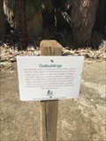 view gallery view gallerySW10.3 km |  Outbuildings - Thousand Palms, CA Outbuildings - Thousand Palms, CA
in Signs of History One of several historical markers at the Thousands Palms Oasis Preserve in Thousand Palms, California posted by: bluesnote location: California date approved: 01/16/2023 last visited: never |
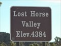 view gallery view galleryNE10.5 km |  Lost Horse Valley, Joshua Tree National Park - 4384 ft Lost Horse Valley, Joshua Tree National Park - 4384 ft
in Elevation Signs This elevation sign is on Keys View Rd which goes to Keys View, the highest point in Joshua Tree National Park. The sign is just over a mile south of Park Boulevard. posted by: PeterNoG location: California date approved: 01/21/2011 last visited: 01/03/2014 |
 view gallery view galleryW10.9 km | DX3455: U 1311 - Sky Valley CA in U.S. Benchmarks This Benchmark is 1000 feet south of Dillon Road on Sky Ridge Road, then 85 feet ESE on Utility Pole Road near Sky Valley, California. posted by: PeterNoG location: California date approved: 09/22/2013 last visited: 12/18/2020 |
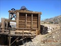 view gallery view galleryE11.1 km |  The Lost Horse Mine, Joshua Tree National Park The Lost Horse Mine, Joshua Tree National Park
in Mines One of several abandoned mines in Joshua Tree National park. posted by: toponym location: California date approved: 04/12/2010 last visited: 01/13/2011 |
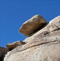 view gallery view galleryNE11.6 km |  Hidden Valley - Joshua Tree NP Hidden Valley - Joshua Tree NP
in Nature's Balanced Rocks Rest Area near Hidden Valley in Joshua Tree National Park posted by: Bernd das Brot Team location: California date approved: 06/24/2008 last visited: 12/21/2014 |
 view gallery view galleryW11.6 km | DX3456: T 1311 - Sky Valley CA in U.S. Benchmarks This Benchmark is in a boulder, just north of Dillon Road, 340 feet northwest from corner of Dillon Road and Topaz Street near Sky Valley, California. posted by: PeterNoG location: California date approved: 09/23/2013 last visited: 12/18/2020 |
 view gallery view galleryNE11.6 km | U.S. Army Corps of Engineers PB #5 Benchmark - Joshua Tree, CA in U.S. Benchmarks One of many benchmarks in Joshua Tree National Park. posted by: bluesnote location: California date approved: 08/15/2024 last visited: never |
|