 view gallery view gallery E21.6 km E21.6 km
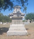
|   Joseph Alexander Kemp - Riverside Cemetery - Wichita Falls, TX Joseph Alexander Kemp - Riverside Cemetery - Wichita Falls, TX
in Grave of a Famous Person Joseph Alexander Kemp was a visionary and entrepreneur whose business and civic activities were vital to the development of Wichita Falls - interred in Riverside Cemetery, Wichita Falls, Texas. posted by:  The Snowdog The Snowdog location: Texas date approved: 07/29/2023 last visited: never |
 view gallery view gallery NE46.5 km NE46.5 km
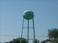
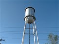
|  PORTALES - Water Tank PORTALES - Water Tank
in Water Towers PORTALES,New Mexico Water Tank posted by:  GEO*Trailblazer 1 GEO*Trailblazer 1 location: New Mexico date approved: 01/13/2007 last visited: 01/13/2007 |
 view gallery view gallery SW54.7 km SW54.7 km
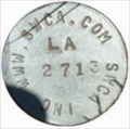
|  SWCA LA 2713 SWCA LA 2713
in U.S. Benchmarks BENCHMARK SWCA LA 2713 posted by: GEO*Trailblazer 1 location: New Mexico date approved: 01/01/2007 last visited: 01/01/2007 |
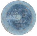 view gallery view gallerySW54.7 km | NMSHTD 2847 27 1996 GPS in U.S. Benchmarks NEW MEXICO STATE HIGHWAY TRANSPORTATION DEPARTMENT 2847 27 posted by: GEO*Trailblazer 1 location: New Mexico date approved: 01/01/2007 last visited: 01/01/2007 |
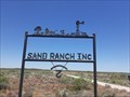 view gallery view gallery S55 km S55 km
|  Sand Ranch - east of Roswell, NM Sand Ranch - east of Roswell, NM
in Silhouette Public Art Sculptures The entry sign to the Sand Ranch incorporates silhouette art of prairie life; east of Roswell, New Mexico posted by: The Snowdog location: New Mexico date approved: 07/23/2020 last visited: never |
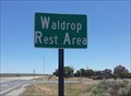 view gallery view galleryS55.2 km |  Waldrop Rest Area - east of Roswell, NM Waldrop Rest Area - east of Roswell, NM
in Highway Rest Areas A well-appointed rest stop on the south side of U.S. Highway 380 between Roswell and Caprock, New Mexico posted by: The Snowdog location: New Mexico date approved: 07/25/2020 last visited: never |
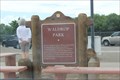 view gallery view galleryS55.2 km |  Waldrop Park -- US380 rest area nr Chaves Co. Line, NM Waldrop Park -- US380 rest area nr Chaves Co. Line, NM
in New Mexico Historical Markers A historic marker in a small but clean rest area on the US 380 jst west of the Chaves County line. posted by: Benchmark Blasterz location: New Mexico date approved: 09/11/2014 last visited: 05/29/2020 |
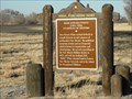
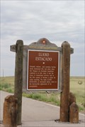 view gallery view galleryS56.3 km | Llano Estacado -- nr Caprock NM in New Mexico Historical Markers A New Mexico state historic marker along the US 380 near Caprock NM posted by: Benchmark Blasterz location: New Mexico date approved: 09/11/2014 last visited: 07/04/2018 |
 view gallery view galleryNE58.6 km | Rose Powers White (1894-1969) in New Mexico Historical Markers This New Mexico Historical Marker, along with one for Blackwater Draw, are at the rest stop near the Black Draw Museum of the Eastern New Mexico University. They are on US 70 about 5 miles northeast of Portales and 10 miles south of Clovis. posted by: PeterNoG location: New Mexico date approved: 10/26/2011 last visited: 03/08/2011 |
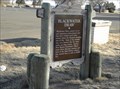 view gallery view galleryNE58.6 km | Blackwater Draw in New Mexico Historical Markers This New Mexico Historical Marker, along with one for Rose Powers White, are at the rest stop near the Black Draw Museum of the Eastern New Mexico University. They are on US 70 about 5 miles northeast of Portales and 10 miles south of Clovis. posted by: PeterNoG location: New Mexico date approved: 10/26/2011 last visited: 03/08/2011 |
 view gallery view gallery N62.4 km N62.4 km
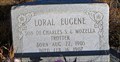
|  Loral Eugene Trotter - Tolar, NM Loral Eugene Trotter - Tolar, NM
in Out of Place Graves This grave is located on the plains of New Mexico, alongside U.S. Highway 60. posted by: rjmcdonough1 location: New Mexico date approved: 11/02/2021 last visited: never |
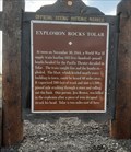 view gallery view galleryN63.9 km | Explosion Rocks Tolar - west of Tolar, NM in New Mexico Historical Markers This New Mexico Historical Marker, on the north side of Highway 84 a few miles west of Tolar, documents a massive explosion that rocked that town in 1944. posted by: The Snowdog location: New Mexico date approved: 05/24/2021 last visited: never |
 view gallery view gallery NW69.4 km NW69.4 km
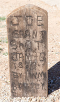
|  Joe Grant - Fort Sumner, NM Joe Grant - Fort Sumner, NM
in Graves Mentioning a Cause of Death A simple, hand-carved wooden grave marker for Joe Grant, who was shot and killed by Billy the Kid on January 10, 1880. posted by: The Snowdog location: New Mexico date approved: 03/19/2019 last visited: never |
 view gallery view galleryNW69.4 km |  Joe Grant - Fort Sumner, NM Joe Grant - Fort Sumner, NM
in Homemade Tombstones A simple hand-carved wooden tombstone for Joe Grant, who was shot and killed by Billy the Kid on January 10, 1880. posted by: The Snowdog location: New Mexico date approved: 03/20/2019 last visited: never |
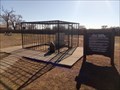 view gallery view galleryNW69.4 km |  Billy The Kid's Grave - Fort Sumner, NM Billy The Kid's Grave - Fort Sumner, NM
in Roadside Attractions The (alleged) grave of gunslinger Billy The Kid is a Roadside Attraction. posted by: The Snowdog location: New Mexico date approved: 09/24/2020 last visited: never |
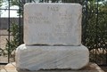 view gallery view galleryNW69.4 km | William Bonney (a.k.a. Billy the Kid) - Fort Sumner, NM in Grave of a Famous Person The grave of William Bonney (Billy the Kid) and two of his Pals, in a small cemetery in Fort Sumner, New Mexico posted by: The Snowdog location: New Mexico date approved: 03/18/2019 last visited: 09/22/2021 |
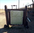 view gallery view galleryNW69.4 km | Old Fort Sumner and "Billy The Kid's" Grave - Fort Sumner, NM in New Mexico Historical Markers This historical marker at old Fort Sumner is near the entrance to the graveyard where Billy The Kid (and at least one of his victims) is interred; southeast of Fort Sumner, New Mexico. posted by: The Snowdog location: New Mexico date approved: 09/23/2020 last visited: 09/22/2021 |
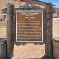 view gallery view galleryNE71.9 km | Ida O. Jackson in New Mexico Historical Markers This marker is located at the corner of Beta Street and W. Grand Avenue in Clovis. It stands next to the Lincoln-Jackson School complex, which was added to the National Register of Historic Places in 2017. posted by: QuesterMark location: New Mexico date approved: 04/19/2024 last visited: never |
 view gallery view galleryNE72.6 km |  Norman Petty Recording Studio - Clovis, NM Norman Petty Recording Studio - Clovis, NM
in Wikipedia Entries The Norman Petty Studio is located at 1313 West 7th Street, Clovis NM. posted by: rjmcdonough1 location: New Mexico date approved: 11/06/2021 last visited: never |
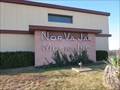 view gallery view galleryNE72.6 km |  Norman Petty Recording Studio - Clovis, NM Norman Petty Recording Studio - Clovis, NM
in Official Local Tourism Attractions The Norman Petty Studio is located at 1313 West 7th Street, Clovis NM. posted by: rjmcdonough1 location: New Mexico date approved: 11/07/2021 last visited: never |
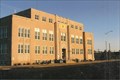
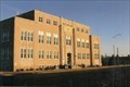
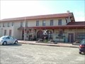 view gallery view galleryNE72.9 km |  Clovis Railroad Station, Clovis, New Mexico Clovis Railroad Station, Clovis, New Mexico
in Train Stations/Depots Clovis Railroad Station,Model Railroad Museum posted by: GEO*Trailblazer 1 location: New Mexico date approved: 12/07/2006 last visited: 03/03/2008 |
 view gallery view galleryNE73.2 km | CLOVIS - Water Tank in Water Towers CLOVIS,NEW MEXICO WATER TANK posted by: GEO*Trailblazer 1 location: New Mexico date approved: 01/08/2007 last visited: 03/06/2008 |
 view gallery view gallery SE73.4 km SE73.4 km
|  Texas / New Mexico on the Bledsoe Highway - SW of Bledsoe, TX Texas / New Mexico on the Bledsoe Highway - SW of Bledsoe, TX
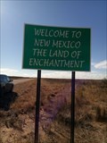
in Border Crossings Texas State Road 125 becomes New Mexico State Road 125 - collectively called the Bledsoe Highway - at this border crossing. posted by: The Snowdog location: New Mexico date approved: 03/16/2019 last visited: never |
 view gallery view galleryNE73.5 km | Clovis, New Mexico in Wikipedia Entries CURRY COUNTY
1909 100 2009
New Mexico posted by: YoSam. location: New Mexico date approved: 08/10/2016 last visited: never |
 view gallery view galleryNE73.5 km | Curry County, New Mexico in Wikipedia Entries County seat: Clovis posted by: YoSam. location: New Mexico date approved: 03/16/2023 last visited: never |
|