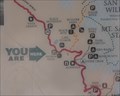
 view gallery view gallery SW4.2 km SW4.2 km
|   Indian Vista Indian Vista
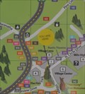
in 'You Are Here' Maps You Are Here at Indian Vista on the Palms to Pines Scenic Byway (California Highway 243), about 14 3/4 miles south of Banning, California. posted by:  brwhiz brwhiz location: California date approved: 12/09/2012 last visited: 07/19/2022 |
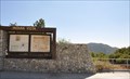 view gallery view gallerySW4.2 km |  Palms to Pines Scenic Byway ~ Indian Vista Palms to Pines Scenic Byway ~ Indian Vista
in National Scenic Byways Indian Vista on the Palms to Pines Scenic Byway is located on the south side of the Palms to Pines Scenic Byway (California Highway 243), about 14 3/4 miles south of Banning, California. posted by: brwhiz location: California date approved: 12/09/2012 last visited: 02/03/2014 |
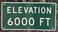
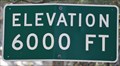 view gallery view gallery S4.7 km S4.7 km
|  Palms to Pines Scenic Byway ~ Elevation 6000 Feet Palms to Pines Scenic Byway ~ Elevation 6000 Feet
in Elevation Signs This Elevation Sign is on the west side of the Palms to Pines Scenic Byway (California Highway 243) at Stonewood Canyon Road, about 20 miles south of Banning, California. posted by: brwhiz location: California date approved: 12/09/2012 last visited: 02/04/2013 |
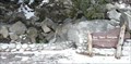 view gallery view gallery W4.8 km W4.8 km
|  Bay Tree Spring - Hwy 243 CA Bay Tree Spring - Hwy 243 CA
in Natural Springs This spring is on Hwy 243 about halfway between Idyllwild and Banning. posted by: PeterNoG location: California date approved: 02/11/2008 last visited: 01/29/2008 |
 view gallery view gallery E5.3 km E5.3 km
|  SAN JACINTO 1898 1923 SET 1954 - California SAN JACINTO 1898 1923 SET 1954 - California
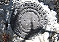
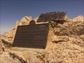
in Azimuth Benchmarks Azimuth Mark Disk mentioned in 1954 Documented History for Triangulation Station "SAN JACINTO" (PID DX5119), along with all three benchmark disks for the station itself. posted by:  Vader! Vader! location: California date approved: 06/29/2009 last visited: 05/20/2015 |
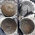 view gallery view galleryE5.3 km |  SAN JACINTO Azimuth Disk w/ Triangulation Station Disks - PID DX5119 SAN JACINTO Azimuth Disk w/ Triangulation Station Disks - PID DX5119
in U.S. Benchmarks Azimuth Mark Disk for Triangulation Station "SAN JACINTO" along with all three benchmark disks for the station itself. posted by: Vader! location: California date approved: 06/29/2009 last visited: 05/20/2015 |
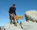
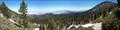 view gallery view galleryE5.3 km |  Santa Rosa and San Jacinto Mountains - San Jacinto Peak Santa Rosa and San Jacinto Mountains - San Jacinto Peak
in National Parks of the World San Jacinto Peak is the second highest peak in Southern California. It has the second steepest elevation gain in the nation. posted by: TerryDad2 location: California date approved: 08/28/2006 last visited: 05/20/2015 |
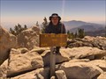
 view gallery view galleryE5.3 km | San Jacinto Peak Triangulation disk in U.S. Benchmarks Benchmark DX5119
This benchmark can be found at the second highest point in southern California at an elevation of 10,834 feet above sea level. posted by: Moag Ohana location: California date approved: 01/08/2008 last visited: 11/16/2017 |
 view gallery view galleryE5.3 km |  Highest Point in Riverside County, Mt San Jacinto Highest Point in Riverside County, Mt San Jacinto
in Geographic High Points Mt San Jacinto is the Highest Point in Riverside County posted by: Rumpled location: California date approved: 01/10/2010 last visited: 05/20/2015 |
 view gallery view galleryE5.3 km |  Mt. San Jacinto, California Mt. San Jacinto, California
in Mountain Summits Mt. San Jacinto is a 10,834 foot peak above Palm Springs. It is the second highest peak in Southern California. posted by: showbizkid location: California date approved: 01/27/2006 last visited: 05/20/2015 |
 view gallery view galleryE6 km | Miller Peak in Mountain Summits Miller Peak on the East flank of San Jacinto Peak in Mount San Jacinto State Park. The peak is above the 10400 contour, so the elevation is 10400+ posted by: Rumpled location: California date approved: 09/19/2008 last visited: never |
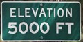 view gallery view galleryW6.8 km | Palms to Pines Scenic Byway ~ Elevation 5000 Feet in Elevation Signs This Elevation Sign is on the south side of the Palms to Pines Scenic Byway (California Highway 243) at Mellor Ranch Road, about 11 miles south of Banning California. posted by: brwhiz location: California date approved: 12/09/2012 last visited: 02/04/2013 |
 view gallery view galleryS6.8 km | Palms to Pines Scenic Byway ~ Elevation 6000 Feet in Elevation Signs This Elevation Sign is on the west side of the Palms to Pines Scenic Byway (California Highway 243) just north of Lakeview Drive, about 21.7 miles south of Banning, California. posted by: brwhiz location: California date approved: 12/09/2012 last visited: 02/04/2013 |
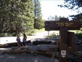 view gallery view galleryE6.9 km |  Round Valley Primative Campground - CA Round Valley Primative Campground - CA
in Campgrounds This is a primative campground in the San Jacinto Wilderness in California. Only accessable by backpacking and with a wilderness permit. posted by: TerryDad2 location: California date approved: 08/29/2006 last visited: 10/24/2009 |
 view gallery view galleryE6.9 km | Round Valley Primative Campground - CA in Free Campsites This is a primative campground in the San Jacinto Wilderness in California. Only accessable by backpacking and with a wilderness permit. posted by: TerryDad2 location: California date approved: 08/29/2006 last visited: 08/10/2008 |
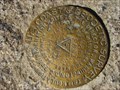
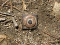 view gallery view gallery SE7.4 km SE7.4 km
| Riverside County Surveyor Benchmark P-21 in U.S. Benchmarks Riverside County Surveyor Mark posted by: rexr location: California date approved: 03/16/2009 last visited: never |
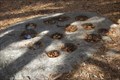 view gallery view galleryS7.4 km |  Idyllwild Indian Mortar Rock Idyllwild Indian Mortar Rock
in New World Ancient Evidence Stone Indian Mortar Rock was used to grind acorns. posted by: geobwong2k location: California date approved: 02/18/2007 last visited: never |
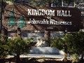 view gallery view galleryS7.6 km |  Kingdom Hall of Jehovah's Witnesses - Idyllwild CA Kingdom Hall of Jehovah's Witnesses - Idyllwild CA
in Kingdom Halls of Jehovah's Witnesses This Kingdom Hall of Jehovah's Witnesses is on Pinecrest Avenue at Alderwood Street in Idyllwild, California. posted by: PeterNoG location: California date approved: 04/08/2013 last visited: 02/04/2013 |
 view gallery view galleryS7.7 km | Mt. San Jacinto State Park, Idyllwild Campground in Campgrounds One of the several campgrounds located in the Mt. San Jacinto State Park. posted by: geobwong2k location: California date approved: 02/18/2007 last visited: 10/10/2013 |
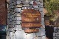
 view gallery view galleryS7.9 km | Idyllwild Village Center in 'You Are Here' Maps You Are Here at the Idyllwild Village Center in the heart of the picturesque mountain village of Idyllwild, California. posted by: brwhiz location: California date approved: 12/09/2012 last visited: 02/04/2013 |
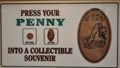 view gallery view galleryS7.9 km |  The Idyllwild Gift Shop Penny Smasher The Idyllwild Gift Shop Penny Smasher
in Penny Smashers This single-design Penny Smasher is in the The Idyllwild Gift Shop at 54260 N Circle Drive in Idyllwild, California. posted by: brwhiz location: California date approved: 10/22/2011 last visited: 02/04/2013 |
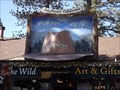 view gallery view galleryS7.9 km |  Wooley's - Idyllwild CA Wooley's - Idyllwild CA
in 3 Dimensional Art This 3 Dimensional Art is a large stetson hat overtop of entrance door at Wooley's Art & Gifts of the Wild posted by: PeterNoG location: California date approved: 06/05/2013 last visited: 05/23/2013 |
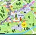 view gallery view galleryS8 km | Harmony Tree Monument in 'You Are Here' Maps You Are Here at the Harmony Tree Monument in the heart of the picturesque mountain village of Idyllwild, California. posted by: brwhiz location: California date approved: 12/09/2012 last visited: 02/04/2013 |
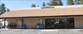 view gallery view galleryS8.2 km |  Idyllwild, California 92549 Idyllwild, California 92549
in U.S. Post Offices This Post Office is located at 54391 Village Center Drive in Idyllwild, California. posted by: brwhiz location: California date approved: 12/25/2011 last visited: 02/04/2013 |
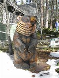 view gallery view galleryS8.4 km |  Bear - Rainbow Inn - Idyllwild CA Bear - Rainbow Inn - Idyllwild CA
in Bear Statues This nicely carved bear is in front of the Rainbow Inn, a Bed & Breakfast, on S Circle Dr in Idyllwild, California. posted by: PeterNoG location: California date approved: 02/21/2011 last visited: 01/15/2011 |
|