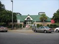
 view gallery view gallery NE13.2 km NE13.2 km
|   I26 Southbound - West Columbia, SC I26 Southbound - West Columbia, SC
in Highway Rest Areas Located on I26 just south of Columbia. posted by:  ChapterhouseInc ChapterhouseInc location: South Carolina date approved: 08/13/2010 last visited: 05/26/2015 |
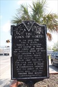 view gallery view gallery S13.7 km S13.7 km
|  The Town of North 38-12, North, SC The Town of North 38-12, North, SC
in South Carolina Historical Markers The Town of North historic marker is located in front of North Town Hall, North, SC. posted by:  Lat34North Lat34North location: South Carolina date approved: 03/27/2011 last visited: 06/18/2002 |
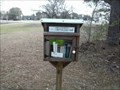 view gallery view gallery W13.7 km W13.7 km
|  Little Free Library #7401 - Pelion, SC Little Free Library #7401 - Pelion, SC
in Free Community Book Exchanges A little free library in a park in Pelion, SC posted by: gpsblake location: South Carolina date approved: 02/09/2016 last visited: never |
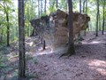 view gallery view gallery NW13.8 km NW13.8 km
|  Peachtree Rock Peachtree Rock
in Nature's Balanced Rocks Peachtree Rock located in the Lexington County South Carolina posted by: Firefrog69 location: South Carolina date approved: 09/06/2007 last visited: 01/28/2022 |
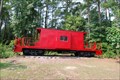 view gallery view galleryNE14.2 km |  Caboose - near Sandy Run, SC Caboose - near Sandy Run, SC
in Train Cabooses Caboose is at the Ruritan Club 1792 Old State Road, Swansea, SC. posted by: carolina1 location: South Carolina date approved: 09/08/2008 last visited: 05/26/2015 |
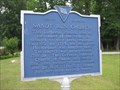 view gallery view galleryNE14.3 km | Sandy Run Church/Christian Theus (9-7) in South Carolina Historical Markers An old church has a long history. posted by: ChapterhouseInc location: South Carolina date approved: 07/05/2010 last visited: 11/28/2003 |
 view gallery view galleryNE14.3 km | Sandy Run Lutheran Church in South Carolina Historical Markers An old church has a long history. posted by: ChapterhouseInc location: South Carolina date approved: 07/05/2010 last visited: 04/13/2011 |
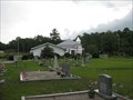 view gallery view galleryNE14.3 km |  Sandy Run Lutheran Church Cemetery - Sandy Run, SC Sandy Run Lutheran Church Cemetery - Sandy Run, SC
in Churchyard Cemeteries A large cemetery behind a country church. posted by: ChapterhouseInc location: South Carolina date approved: 09/12/2010 last visited: 04/13/2011 |
 view gallery view galleryNE14.3 km |  Sandy Run Lutheran Cemetery - Sandy Run, SC Sandy Run Lutheran Cemetery - Sandy Run, SC
in Worldwide Cemeteries A large cemetery behind a country church. posted by: ChapterhouseInc location: South Carolina date approved: 09/13/2010 last visited: 04/13/2011 |
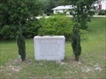
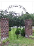
 view gallery view galleryNE14.3 km |  Selena Nelson Arch - Sandy Run, SC Selena Nelson Arch - Sandy Run, SC
in Citizen Memorials The Sandy Run Cemetery eltrance arch is dedicated to a former member. posted by: ChapterhouseInc location: South Carolina date approved: 09/12/2010 last visited: 04/13/2011 |
 view gallery view gallery N16.7 km N16.7 km
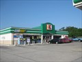
|  Charleston Hwy Kangaroo Subway - West Columbia, SC Charleston Hwy Kangaroo Subway - West Columbia, SC
in Subway Restaurants Located just off I26, inside a Kangaroo gas station. posted by: ChapterhouseInc location: South Carolina date approved: 06/21/2010 last visited: 04/13/2011 |
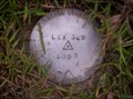
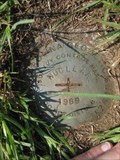
 view gallery view galleryNW22 km |  LEX 269 2003 - PID# DH3368 LEX 269 2003 - PID# DH3368
in U.S. Benchmarks recovered in good condition at intersection of Platt Springs Rd & South Lake Drive south of Lexington, SC posted by: gpsblake location: South Carolina date approved: 10/11/2006 last visited: 05/26/2015 |
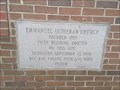 view gallery view galleryN22.2 km |  1998 - Emmanuel Lutheran Church 1998 - Emmanuel Lutheran Church
in Dated Buildings and Cornerstones cornerstone of Emmanuel Lutheran Church on Emmanuel church Road posted by: gpsblake location: South Carolina date approved: 01/13/2015 last visited: 08/12/2015 |
 view gallery view galleryN22.4 km | Congaree Fort (32-1) in South Carolina Historical Markers One of many historic fortifications around the area. posted by: ChapterhouseInc location: South Carolina date approved: 07/05/2010 last visited: 06/18/2002 |
 view gallery view galleryN22.4 km |  FIRST frontier outpost in central South Carolina FIRST frontier outpost in central South Carolina
in First of its Kind The location of the first of many historic forts in the area. posted by: ChapterhouseInc location: South Carolina date approved: 07/05/2010 last visited: 06/24/2010 |
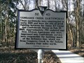 view gallery view galleryN23 km | 32 40 - Congaree Creek Earthworks in South Carolina Historical Markers Historical marker placed along the Timmerman Trail in 2015. It is about a 1/2 mile walk from the parking area. posted by: gpsblake location: South Carolina date approved: 02/12/2015 last visited: never |
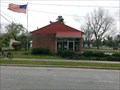 view gallery view galleryS23.2 km |  Neeses, SC 29107 Neeses, SC 29107
in U.S. Post Offices small brick post office in Neeses, SC (population 374) posted by: gpsblake location: South Carolina date approved: 04/07/2015 last visited: never |
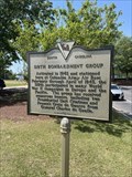
 view gallery view galleryN23.3 km | 345th Bombardment Group in South Carolina Historical Markers Historical marker located in West Columbia, SC. posted by: electrical_chris location: South Carolina date approved: 05/09/2023 last visited: 05/09/2023 |
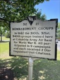 view gallery view galleryN23.5 km | Bombardment Groups in South Carolina Historical Markers Historical marker located in West Columbia, SC. posted by: electrical_chris location: South Carolina date approved: 05/12/2023 last visited: 05/13/2023 |
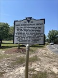
 view gallery view galleryN23.5 km | 319th Bombardment Group in South Carolina Historical Markers Historical marker located in West Columbia, SC. posted by: electrical_chris location: South Carolina date approved: 05/14/2023 last visited: 05/14/2023 |
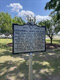 view gallery view galleryN23.5 km | Columbia Army Air Base - The Doolittle Raiders in South Carolina Historical Markers Historical marker located in West Columbia, SC. posted by: electrical_chris location: South Carolina date approved: 05/18/2023 last visited: 05/18/2023 |
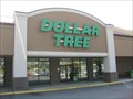 view gallery view galleryN23.5 km |  Charleston Hwy Dollar Tree - Cayce, SC Charleston Hwy Dollar Tree - Cayce, SC
in Dollar Stores Located in the Cayce Commons shopping complex. posted by: ChapterhouseInc location: South Carolina date approved: 10/04/2010 last visited: 05/26/2015 |
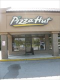 view gallery view galleryN23.5 km |  Charleston Hwy Pizza Hut - Cayce, SC Charleston Hwy Pizza Hut - Cayce, SC
in Pizza Hut Restaurants Small counter service in a grocery store complex. posted by: ChapterhouseInc location: South Carolina date approved: 10/01/2010 last visited: 05/26/2015 |
 view gallery view galleryN23.7 km | LEX 329 - PID# DH3427 in U.S. Benchmarks Located at intersection of US 21 and SC 2 in Cayce, SC posted by: gpsblake location: South Carolina date approved: 10/11/2006 last visited: 06/24/2010 |
 view gallery view galleryNE24.1 km | DE3192 - Nuclear in U.S. Benchmarks Located on the sholder of Bluff Rd on the Westinghouse Property. Park on opposite side of road. posted by: ChapterhouseInc location: South Carolina date approved: 06/21/2010 last visited: 06/20/2010 |
|