 view gallery view gallery N6 km N6 km
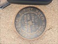
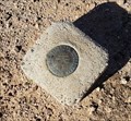
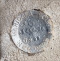
|   USGS BENCH MARK 1957 - 1845 feet, 22 WLS - 1957 USGS BENCH MARK 1957 - 1845 feet, 22 WLS - 1957
in U.S. Benchmarks This marker gives the elevation at this location. posted by:  T2D T2D location: Arizona date approved: 01/11/2019 last visited: 01/02/2021 |
 view gallery view gallery NW8.7 km NW8.7 km
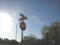
|  Casey's street Casey's street
in Your Name Here Casey Surname Street Sign posted by: ILuvAZ location: Arizona date approved: 06/20/2013 last visited: 01/04/2019 |
 view gallery view gallery S12.7 km S12.7 km
| Dept. of the Interior BM - Tonopah, AZ in U.S. Benchmarks A benchmark to mark the ROW for the Central Arizona Project Canal. posted by: rjmcdonough1 location: Arizona date approved: 03/28/2024 last visited: never |
 view gallery view gallery NE15 km NE15 km
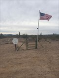
|  Verde Flat Cemetery aka Vulture City Cemetery, Vulture City, Arizona Verde Flat Cemetery aka Vulture City Cemetery, Vulture City, Arizona
in Worldwide Cemeteries Verde Flat Cemetery AKA Vulture City Pioneer Cemetery. Circa 1870. This historic piece of land gets little notice and few visitors although it is only 1/4 mile from Vulture City Mine. posted by: T2D location: Arizona date approved: 01/23/2019 last visited: never |
 view gallery view gallery SE21.6 km SE21.6 km
| U.S. Geological Survey Marker 1223 - Tonopah, AZ in U.S. Benchmarks This marker is located alon Aguilla Rd, northeast of Tonopah, Arizona. posted by: rjmcdonough1 location: Arizona date approved: 03/28/2024 last visited: never |
 view gallery view galleryS22.2 km | Bench Mark 1969 - Tonopah, AZ in U.S. Benchmarks This marker is located alongside Interstate 10 in Tonopah, Arizona. posted by: rjmcdonough1 location: Arizona date approved: 03/20/2024 last visited: never |
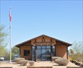 view gallery view galleryS22.7 km |  Tonopah, Arizona 85354 Tonopah, Arizona 85354
in U.S. Post Offices This Post Office is located at 3939 N 411th Avenue in Tonopah, Arizona. posted by: brwhiz location: Arizona date approved: 11/06/2011 last visited: 01/03/2022 |
 view gallery view gallerySE22.7 km | U.S. Geological Survey Marker 1203 - Tonopah, AZ in U.S. Benchmarks Another elevation marker along Aguilla Rd. northeast of Tonopah. posted by: rjmcdonough1 location: Arizona date approved: 04/03/2024 last visited: never |
 view gallery view galleryS22.7 km |  Tonopah, Arizona Tonopah, Arizona
in Wikipedia Entries Tonopah is a small crossroads settlement along I-10/Hwy. 80 about 50 miles west of Phoenix, Arizona. posted by: rjmcdonough1 location: Arizona date approved: 05/27/2020 last visited: never |
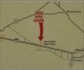
 view gallery view gallery SW23.7 km SW23.7 km
|  Burnt Well Westbound Rest Area #1 Burnt Well Westbound Rest Area #1
in 'You Are Here' Maps You Are Here at the Burnt Well westbound Rest Area on Interstate Highway 10 at about mile marker 86, east of Tonopah, Arizona. posted by: brwhiz location: Arizona date approved: 11/22/2012 last visited: never |
 view gallery view gallerySW23.7 km |  Arizona's Amazing Cacti Arizona's Amazing Cacti
in Flora and Fauna Information Signs This Flora and Fauna Information Sign is located in the Burnt Well Westbound Rest Area on Interstate Highway 10 at about mile marker 86, west of Tonopah, Arizona. posted by: brwhiz location: Arizona date approved: 11/26/2012 last visited: never |
 view gallery view gallerySW23.7 km | Burnt Well Westbound Rest Area #2 in 'You Are Here' Maps You Are Here at the Burnt Well Westbound Rest Area on Interstate Highway 10 at about mile marker 86, east of Tonopah, Arizona. posted by: brwhiz location: Arizona date approved: 11/22/2012 last visited: never |
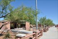 view gallery view gallerySW23.7 km |  Burnt Well Westbound Rest Area Burnt Well Westbound Rest Area
in Highway Rest Areas The Burnt Well Westbound Rest Area is located on Interstate Highway 10 at about mile marker 86, west of Tonopah, Arizona. posted by: brwhiz location: Arizona date approved: 11/22/2012 last visited: 04/03/2019 |
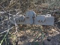 view gallery view galleryS23.7 km |  Kilroy was here too!-Tonopah, Arizona Kilroy was here too!-Tonopah, Arizona
in Kilroy Was Here Found Kilroy while I was geocaching.. posted by: grandmabetsy location: Arizona date approved: 02/22/2018 last visited: 01/24/2019 |
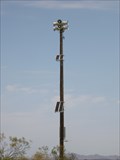 view gallery view galleryS24.9 km |  Palo Verde Nuclear Power Plant Warning Siren Palo Verde Nuclear Power Plant Warning Siren
in Outdoor Warning Sirens Palo Verde Nuclear Power Plant Warning Siren posted by: ILuvAZ location: Arizona date approved: 07/15/2013 last visited: 01/24/2019 |
 view gallery view gallerySE25.7 km | Elevation Station 1988 - Buckeye, AZ in U.S. Benchmarks This marker sits at the base of the guard rail for a culvert and appears to have received a bit of paint spray over. posted by: rjmcdonough1 location: Arizona date approved: 02/14/2023 last visited: never |
 view gallery view gallery E27.4 km E27.4 km
|  Sun City Festival Pet Park - Buckeye, AZ Sun City Festival Pet Park - Buckeye, AZ
in Off-Leash Dog Areas The park is on the north edge of Buckeye, 26720 West Firehawk Drive. posted by: elyob location: Arizona date approved: 01/30/2019 last visited: never |
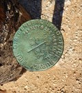
 view gallery view galleryN28.6 km | 4NL1 - Height Modernization Survey Station in U.S. Benchmarks PID AJ3628
STATE/COUNTY AZ/MARICOPA
USGS QUAD VULTURE PEAK (1990) posted by: Arizona Ranger Team location: Arizona date approved: 06/11/2011 last visited: never |
 view gallery view galleryE29.9 km | U.S. Landmark Survey 1915 - Surprise, AZ in U.S. Benchmarks This marker sits next to a railroad tie fence post. posted by: rjmcdonough1 location: Arizona date approved: 10/07/2022 last visited: never |
 view gallery view gallerySE30.4 km | Maricopa County EL Marker 1299.08 in U.S. Benchmarks Maricopa County Elevation Marker posted by: jepaz location: Arizona date approved: 07/09/2011 last visited: 07/08/2011 |
 view gallery view galleryS30.7 km | Wintersburg, Arizona in Wikipedia Entries Wintersburg is a crossroads community west of Phoenix, Arizona. posted by: rjmcdonough1 location: Arizona date approved: 10/15/2023 last visited: never |
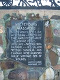 view gallery view galleryN31.9 km |  Wickenburg Massacre Wickenburg Massacre
in Arizona Historical Markers On the morning of November 5th, 1871, a stagecoach carrying seven passengers and driver was ambushed eight miles west of Wickenburg while en- route to Culling’s Well, Ehrenburg and San Bernardino. This event led to the death of seven people. posted by:  leadhiker leadhiker location: Arizona date approved: 05/25/2010 last visited: 11/26/2015 |
 view gallery view galleryNE32.5 km | 4MH2 - Height Modernization Survey Station in U.S. Benchmarks PID AJ3892
STATE/COUNTY AZ/MARICOPA
USGS QUAD WICKENBURG (1978) posted by: Arizona Ranger Team location: Arizona date approved: 06/11/2011 last visited: never |
 view gallery view galleryNW32.5 km | Eagle Eye Cemetery - Aguila, Arizona in Worldwide Cemeteries Eagle Eye Cemetery, a very quiet cemetery with views that lend to lots of peace and the ability to just breathe! posted by: T2D location: Arizona date approved: 01/23/2019 last visited: 01/23/2019 |
 view gallery view galleryNE32.7 km | Vulture Mine in Arizona Historical Markers The Vulture Mine produced gold worth more than 200 million dollars. The mine sparked the development of Arizona and the city of Phoenix. posted by: leadhiker location: Arizona date approved: 05/25/2010 last visited: 12/05/2018 |
|