 view gallery view gallery E3.4 km E3.4 km
|   McDonalds - Ocean Hwy. - Pauleys Island, SC McDonalds - Ocean Hwy. - Pauleys Island, SC
in McDonald's Restaurants The Pauleys Island McDonalds. posted by:  papermanone & catlover papermanone & catlover location: South Carolina date approved: 01/22/2007 last visited: never |
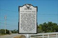
 view gallery view galleryE3.7 km |  22-31 P.C.J. Weston House/Pelican Inn 22-31 P.C.J. Weston House/Pelican Inn
in South Carolina Historical Markers Located at 506 Myrtle Avenue, Pawleys Island, South Carolina. Erected by Pawleys Island Civiv Association-1993. posted by:  mikemtn mikemtn location: South Carolina date approved: 10/22/2006 last visited: 04/06/2016 |
 view gallery view gallery SE3.7 km SE3.7 km
| 22-33 Ward House/Liberty Lodge in South Carolina Historical Markers Located at 520 Myrtle Avenue, Pawleys Island, South Carolina. Erected bt Pawleys Island Civic Association-1993. posted by: mikemtn location: South Carolina date approved: 10/22/2006 last visited: 04/06/2016 |
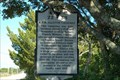
 view gallery view galleryE3.7 km | 22-32 All Saints Summer Parsonage/The Rectory in South Carolina Historical Markers Located at 506 Myrtle Avenue, Pawleys Island, South Carolina. Erected by Pawleys Island Civic Association-1993. posted by: mikemtn location: South Carolina date approved: 10/22/2006 last visited: 04/06/2016 |
 view gallery view galleryE3.7 km | 22-30 R.F.W Allston House in South Carolina Historical Markers Located at 458 Myrtle Avenue, Pawleys Island, South Carolina. Erected by Pawleys Island Civic Association-1993. posted by: mikemtn location: South Carolina date approved: 10/22/2006 last visited: 06/29/2012 |
 view gallery view gallerySE3.7 km | 22-36 LaBruce/Lemon House in South Carolina Historical Markers Located at 546 Myrtle Avenue, Pawleys Island, South Carolina. Erected by Pawleys Island Civic Association-1993. posted by: mikemtn location: South Carolina date approved: 10/22/2006 last visited: 04/06/2016 |
 view gallery view gallerySE3.7 km | 22-34 Nesbitt/Norburn House in South Carolina Historical Markers Located at 560 Myrtle Avenue, Pawleys Island, South Carolina. Erected by Pawleys Island Civic Association-1993. posted by: mikemtn location: South Carolina date approved: 10/22/2006 last visited: 06/29/2012 |
 view gallery view galleryE3.7 km | 22-38 R.F.W Allston Causeway in South Carolina Historical Markers Located on the SW corner intersection of roads 266 and 10 in Pawleys Island, South Carolina. Erected by Pawleys Island Civic Association-1994. posted by: mikemtn location: South Carolina date approved: 10/22/2006 last visited: 07/10/2012 |
 view gallery view gallerySE3.7 km | 22-35 All Saints Academy Summer House in South Carolina Historical Markers Located at 566 Myrtle Avenue, Pawleys Island, South Carolina. Ereced by Pawleys Island Civic Association-1933. posted by: mikemtn location: South Carolina date approved: 10/22/2006 last visited: 04/06/2016 |
 view gallery view galleryE3.7 km | 22-29 Joseph Blyth Allston House (Pawley House) in South Carolina Historical Markers Located at 441 Myrtle Avenue in Pawleys Island, South Carolina. Erected by Pawleys Island Civic Association-1993. posted by: mikemtn location: South Carolina date approved: 10/22/2006 last visited: 04/06/2016 |
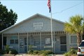 view gallery view galleryE4 km |  Pawleys Island, South Carolina Pawleys Island, South Carolina
in City and Town Halls This is the Town Hall in the small seaside village of Pawleys Island, South Carolina. posted by: mikemtn location: South Carolina date approved: 10/22/2006 last visited: 04/06/2016 |
 view gallery view galleryE4 km | 22-26 Pawleys Island & Waccamaw Neck in South Carolina Historical Markers Located at the Town Hall in Pawleys Island, South Carolina. Erected by Waccamaw Garden Club-1975. posted by: mikemtn location: South Carolina date approved: 10/22/2006 last visited: 06/29/2012 |
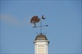 view gallery view galleryE4 km |  Palmetto Heritage Bank Weathervane - Pawleys Island, SC Palmetto Heritage Bank Weathervane - Pawleys Island, SC
in Unique Weathervanes This weathervane is located on top of the Palmetto Heritage Bank in Pawleys Island, SC. posted by: Hawaiian Ninja location: South Carolina date approved: 10/13/2008 last visited: 04/09/2010 |
 view gallery view galleryE4.2 km |  Pauleys Island, SC 29585 Pauleys Island, SC 29585
in U.S. Post Offices The Pauleys Island Post Office. posted by: papermanone & catlover location: South Carolina date approved: 01/21/2007 last visited: never |
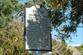
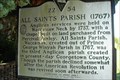 view gallery view gallery NE4.7 km NE4.7 km
| 22-54 All Saints Parish Church (1767) in South Carolina Historical Markers Pawleys Island posted by:  BuckeyeBeckster BuckeyeBeckster location: South Carolina date approved: 05/22/2009 last visited: 05/12/2014 |
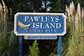 view gallery view galleryNE5.5 km |  Pawleys Island Community Sign Pawleys Island Community Sign
in Eagle Scout Project Sites This is the Eagle Scout project for Richard Saum. posted by: Hawaiian Ninja location: South Carolina date approved: 10/13/2008 last visited: 06/29/2012 |
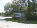 view gallery view galleryNE5.5 km |  OLDEST Seaside Resort in America OLDEST Seaside Resort in America
in Superlatives This welcome sign, a Eagle Scout Project, proclaims this the Oldest Seaside Resort in America. posted by: ChapterhouseInc location: South Carolina date approved: 04/30/2010 last visited: 07/10/2012 |
 view gallery view gallery W7.7 km W7.7 km
|  True Blue, Pawleys Island South Carolina True Blue, Pawleys Island South Carolina
in Public and Private Golf Courses True Blue Plantation
900 Blue Stem Drive, Pawleys Island, SC 29585
(888) 483-6800 - (843) 235-0900
posted by: natural9 location: South Carolina date approved: 05/12/2008 last visited: 09/09/2004 |
 view gallery view galleryW8 km | Wedgefield Plantation Golf - Georgetown, SC in Public and Private Golf Courses Wedgefield Plantation Golf is about 2 miles North of Georgetown, SC. posted by: papermanone & catlover location: South Carolina date approved: 02/02/2007 last visited: never |
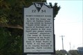
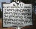 view gallery view gallery N8.4 km N8.4 km
| 22-52 Prince Frederick's Chapel in South Carolina Historical Markers SC historical marker 22-52 posted by: rrrparker location: South Carolina date approved: 02/10/2018 last visited: 02/10/2018 |
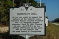 view gallery view gallery SW8.9 km SW8.9 km
| 22-4 Prospect Hill in South Carolina Historical Markers Located on US 17 East of Georgetown, South Carolina about 1.7 miles East of the Waccamaw River. Erected by Georgetown County Historical Socirty-1991. posted by: mikemtn location: South Carolina date approved: 10/22/2006 last visited: 02/15/2018 |
 view gallery view galleryNE9 km |  US 17 Turtle Crossing - North Litchfield Beach, SC US 17 Turtle Crossing - North Litchfield Beach, SC
in Turtle Crossings Ok, so this isn't really 'my' turtle xing, but this guy was already saving it. posted by: ChapterhouseInc location: South Carolina date approved: 04/15/2010 last visited: 04/06/2016 |
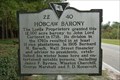 view gallery view gallerySW9.5 km | 22-40 Hobcaw Barony in South Carolina Historical Markers Located on US 17 North of Georgetown, South Carolina. Erected by The Belle W. Baruch Foundation-1995. posted by: mikemtn location: South Carolina date approved: 10/13/2006 last visited: 07/19/2009 |
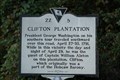 view gallery view gallerySW9.8 km | 22-5 Clifton Plantation in South Carolina Historical Markers Located on US 17 East of Georgetown, .08 miles East of the Waccamaw River. Erected by the Georgetown County Historical Society-1991. posted by: mikemtn location: South Carolina date approved: 10/22/2006 last visited: 02/15/2018 |
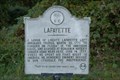 view gallery view gallerySW9.8 km | 22-8 Lafayette in South Carolina Historical Markers Located on US 17 East of Georgetown, 0.8 miles from Harrell Siau Bridge that spans the Waccamaw River. Erected by Georgetown County-1940. posted by: mikemtn location: South Carolina date approved: 10/22/2006 last visited: 06/21/2002 |
|