 view gallery view gallery NW19.3 km NW19.3 km
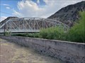
|   Whitewater Creek - Glenwood, New Mexico Whitewater Creek - Glenwood, New Mexico
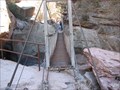
in Pedestrian Suspension Bridges Old pedestrian suspension bridge spanning Whitewater Creek at the upper end of the Catwalk National Recreation Trail. posted by:  linkys linkys location: New Mexico date approved: 04/06/2008 last visited: 05/18/2011 |
 view gallery view gallery W22.9 km W22.9 km
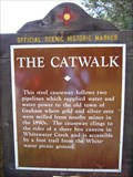
|  The Catwalk The Catwalk
in New Mexico Historical Markers A New Mexico OSHM near Glenwood on US-180. posted by: leadhiker location: New Mexico date approved: 06/07/2011 last visited: never |
 view gallery view gallery SE23 km SE23 km
|  TURKEY CREEK HOT SPRINGS TURKEY CREEK HOT SPRINGS
in Hot Springs TURKEY CREEK HOT SPRINGS GILA WILDERNESS posted by: GEO*Trailblazer 1 location: New Mexico date approved: 11/14/2006 last visited: 10/09/2009 |
 view gallery view galleryW23.2 km |  Glenwood Ranger Station - Gila National Forest Glenwood Ranger Station - Gila National Forest
in Ranger Stations US Forest Service Ranger District in southwestern New Mexico that includes the Catwalk National Recreation Area. posted by: linkys location: New Mexico date approved: 03/31/2008 last visited: never |
 view gallery view galleryW25.3 km | Mogollon in New Mexico Historical Markers The name, Mogollon, prominent in the topography and history of the southwest, is attached to both the mountains and a ghost town in this area of New Mexico. posted by: linkys location: New Mexico date approved: 12/17/2009 last visited: 01/24/2015 |
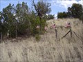 view gallery view galleryNW27.2 km |  W.S. Ranch Cemetery W.S. Ranch Cemetery
in Abandoned Cemeteries Located just outside of Alma, NM. Alma is north of Silver City, NM. posted by:  beagle39z beagle39z location: New Mexico date approved: 04/10/2007 last visited: never |
 view gallery view gallery SW43.6 km SW43.6 km
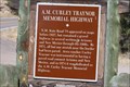
| A. M. Curley Traynor Memorial Highway - Mule Creek, NM in New Mexico Historical Markers New Mexico Historical Marker commemorating local rancher A. M. Curley Traynor and N.M./Az. Highway 78. posted by: outwest63 location: New Mexico date approved: 06/09/2014 last visited: never |
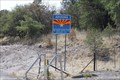 view gallery view gallerySW43.8 km |  AZ/NM Hwy 78 AZ/NM Hwy 78
in Border Crossings Az./N.M. border crossing on Highway 78 posted by: outwest63 location: Arizona date approved: 06/09/2014 last visited: never |
 view gallery view gallery N47 km N47 km
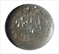
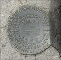
|  US BUREAU OF PUBLIC ROADS 5764.34 9 US BUREAU OF PUBLIC ROADS 5764.34 9
in U.S. Benchmarks US BUREAU OF PUBLIC ROADS BM 5764.34 9 posted by: GEO*Trailblazer 1 location: New Mexico date approved: 01/01/2007 last visited: 01/01/2007 |
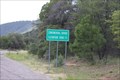
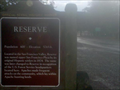 view gallery view galleryN47 km | Reserve OSHM in New Mexico Historical Markers OSHM sign for Reserve,NM posted by: kingbee location: New Mexico date approved: 08/19/2010 last visited: 07/02/2012 |
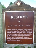 view gallery view galleryNW48 km | Reserve in New Mexico Historical Markers There are two OSHM's for Reserve. The other one is about 6 miles east. posted by: leadhiker location: New Mexico date approved: 06/07/2011 last visited: 07/02/2012 |
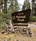 view gallery view gallerySE60.4 km |  Gila National Forest - NM Gila National Forest - NM
in Public Access Lands The Gila is 2.7 million acres of forested hills, majestic mountains and range land. It is probably best known for its wilderness areas, in particular the Gila Wilderness - the first wilderness in the United States. [-Gila Nat'l Forest homepage] posted by: QuesterMark location: New Mexico date approved: 08/28/2018 last visited: 08/23/2019 |
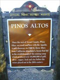 view gallery view gallerySE62.8 km | Pinos Altos in New Mexico Historical Markers Marker is on New Mexico Route 15 at milepost 6.2, on the right when traveling north. posted by: leadhiker location: New Mexico date approved: 06/21/2011 last visited: 08/25/2016 |
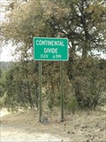
 view gallery view gallerySE62.8 km |  Continental Divide - Pinos Altos, New Mexico Continental Divide - Pinos Altos, New Mexico
in Elevation Signs Continental Divide Elevation Sign on New Mexico Highway 15 at South Entrance to Pinos Altos, NM posted by: outwest63 location: New Mexico date approved: 08/28/2016 last visited: 02/18/2024 |
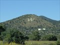 view gallery view gallerySE64.2 km |  W ON PINOS ALTOS MOUNTAIN W ON PINOS ALTOS MOUNTAIN
in Letters on Hills W (WNMU)WESTERN NEW MEXICO UNIVERSITY posted by: GEO*Trailblazer 1 location: New Mexico date approved: 11/15/2006 last visited: 01/12/2015 |
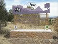 view gallery view gallerySE64.2 km |  Trail of the Mountain Spirits Scenic Byway Trail of the Mountain Spirits Scenic Byway
in National Scenic Byways This 93-mile National Scenic Byway winds through the Gila National Forest in southwestern New Mexico. posted by: PeterNoG location: New Mexico date approved: 10/26/2011 last visited: 07/05/2018 |
 view gallery view gallerySE65.2 km | Continental Divide - Elev. 6,599 in Elevation Signs This Elevation Sign is on New Mexico Hwy 35 in the Gila National Forest. It's about 11.5 miles north of Mimbres and 26 miles south Gila Hot Springs. posted by: PeterNoG location: New Mexico date approved: 10/26/2011 last visited: 02/18/2024 |
 view gallery view gallerySE65.5 km | CY0087: F 124 - Gila National Forest NM in U.S. Benchmarks This Benchmark is on Sapillo Loop Road (Hwy 35) at North Star Road in the Gila National Forest. posted by: PeterNoG location: New Mexico date approved: 11/26/2013 last visited: 03/06/2011 |
 view gallery view gallery S65.8 km S65.8 km
|  The Bayard Union Hall mural The Bayard Union Hall mural
in Murals The Bayard Union Hall mural was created by students with help from local artists to honor local residents past and present.
The strike at the Empire Zinc Company mine in Hanover, New Mexico, October 1950 to February 1952, was the inspiration for the movie “Salt of the Earth.” posted by: beagle39z location: New Mexico date approved: 04/09/2007 last visited: never |
 view gallery view gallerySE66.8 km | Silver City in New Mexico Historical Markers A New Mexico OSHM on U.S. 180 at milepost 111.5. posted by: leadhiker location: New Mexico date approved: 06/21/2011 last visited: 01/07/2015 |
 view gallery view gallerySE66.9 km | North Silver Street mural in Murals North Silver Street mural, the first mural project near the corner of Maple & North Silver Street, was completed with help from artist Diana Ingalls Leyba. posted by: beagle39z location: New Mexico date approved: 04/07/2007 last visited: 05/18/2011 |
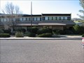
 view gallery view gallerySW66.9 km |  Clifton Town Library Clifton Town Library
in Libraries Books, Books on Tape, CDs, VHS and DVD movies. posted by: Me & Bucky location: Arizona date approved: 08/19/2005 last visited: 06/01/2019 |
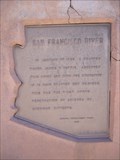 view gallery view gallerySW67.3 km |  San Francisco River San Francisco River
in Arizona Historical Markers In January, 1825 on a river they called St. Francisco, they caught 250 beavers over the next couple of weeks posted by: leadhiker location: Arizona date approved: 06/07/2011 last visited: never |
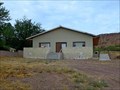 view gallery view gallerySW67.3 km |  York Valley Church - Duncan, AZ York Valley Church - Duncan, AZ
in Religious Buildings Multifarious This is a simple country church in the census designated area of York Valley, Arizona. posted by: rjmcdonough1 location: Arizona date approved: 05/22/2019 last visited: never |
 view gallery view gallerySW67.3 km |  Park Avenue Bridge - Clifton, AZ Park Avenue Bridge - Clifton, AZ
in U.S. National Register of Historic Places Park Avenue Bridge is a through truss bridge over the San Francisco River in Clifton. posted by: rjmcdonough1 location: Arizona date approved: 06/19/2022 last visited: 05/21/2017 |
|