 view gallery view gallery NE1.6 km NE1.6 km
|   Queen Valley Book Exchange - Queen Valley, AZ Queen Valley Book Exchange - Queen Valley, AZ
in Free Community Book Exchanges This book exchange, on the model of the Little Free Library, is located in Queen Valley, AZ. posted by:  rjmcdonough1 rjmcdonough1 location: Arizona date approved: 10/28/2018 last visited: 11/12/2018 |
 view gallery view galleryNE1.6 km |  Queen Valley, Arizona Queen Valley, Arizona
in Wikipedia Entries Queen Valley is a census designated place east of Phoenix, Arizona. posted by: rjmcdonough1 location: Arizona date approved: 11/03/2018 last visited: 11/12/2018 |
 view gallery view gallery E1.6 km E1.6 km
|  The Church at Queen Valley - Queen Valley, AZ The Church at Queen Valley - Queen Valley, AZ
in Baptist Churches This church serves the Baptist community in the retirement community of Queen Valley, Arizona. posted by: rjmcdonough1 location: Arizona date approved: 11/07/2018 last visited: 11/12/2018 |
 view gallery view galleryE1.8 km |  Queen Valley Fire District No. 1 Queen Valley Fire District No. 1
in Firehouses Queen Valley Fire Department provides services to the 12 square miles of the town and supports the nearby community of Superior. posted by: rjmcdonough1 location: Arizona date approved: 11/05/2018 last visited: 11/12/2018 |
 view gallery view gallery W2.4 km W2.4 km
| U.S. Route 80 in Arizona - Florence Junction, AZ in Wikipedia Entries U.S. Highway 80 travelled 500 miles through Arizona before being decommissioned in 1989. posted by: rjmcdonough1 location: Arizona date approved: 06/06/2018 last visited: 11/12/2018 |
 view gallery view galleryW2.4 km |  Queen Creek Bridge - Florence Junction, AZ Queen Creek Bridge - Florence Junction, AZ
in U.S. National Register of Historic Places This bridge once carried U.S. 60/80 on the way to Phoenix. posted by: rjmcdonough1 location: Arizona date approved: 05/28/2018 last visited: 11/12/2018 |
 view gallery view galleryW2.4 km |  Queen Creek Bridge - Florence Junction, AZ Queen Creek Bridge - Florence Junction, AZ
in Arch Bridges This bridge once carried U.S. 60/80 on the way to Phoenix. posted by: rjmcdonough1 location: Arizona date approved: 05/28/2018 last visited: 11/12/2018 |
 view gallery view galleryW2.4 km |  U.S. C&G Survey Benchmark J107 - Florence Junction, AZ U.S. C&G Survey Benchmark J107 - Florence Junction, AZ
in U.S. Benchmarks This benchmark is located on the northwest corner of the Queen Creek Bridge near Florence Junction, AZ posted by: rjmcdonough1 location: Arizona date approved: 05/29/2018 last visited: 11/12/2018 |
 view gallery view gallery S3.9 km S3.9 km
| AZ DOT Right of Way Marker - Florence Junction, AZ in U.S. Benchmarks This Right of Way marker is beside a former alignment of the U.S. 60 outside of Florence Junction, AZ. posted by: rjmcdonough1 location: Arizona date approved: 02/15/2018 last visited: never |
 view gallery view gallery SW4 km SW4 km
| Pinal County Section Marker - Florence Junction, AZ in U.S. Benchmarks This marker is located East of El Camino Viejo near Florence Junction, Arizona. posted by: rjmcdonough1 location: Arizona date approved: 10/28/2018 last visited: never |
 view gallery view galleryS4.8 km | Pinal County T2SR10E in U.S. Benchmarks Pinal County 1962 posted by: jepaz location: Arizona date approved: 07/08/2011 last visited: 04/24/2011 |
 view gallery view gallerySW4.8 km | AZ Highway Div, El Camino Viejo - Florence Junction, AZ in U.S. Benchmarks This benchmark lies along the original alignment of US 60/70/80 at Florence Junction, AZ. posted by: rjmcdonough1 location: Arizona date approved: 10/28/2018 last visited: never |
 view gallery view gallerySW5.3 km | A.D.O.T. Marker LS 31034 - Florence Junction, AZ in U.S. Benchmarks This marker is at the fence line marking the southern edge of the U.S. 60 alignment. posted by: rjmcdonough1 location: Arizona date approved: 03/28/2018 last visited: never |
 view gallery view galleryW6.4 km | ADOT Highway Div JET RM 1 1975 in U.S. Benchmarks ADOT Highway Div JET RM 1 1975 posted by: jepaz location: Arizona date approved: 07/11/2011 last visited: 07/11/2011 |
 view gallery view galleryW7.9 km |  Highway 80 Bridge - Florence Junction, AZ Highway 80 Bridge - Florence Junction, AZ
in Orphaned Bridges This bridge once carried U.S. Hwy 60/80 across a desert wash. posted by: rjmcdonough1 location: Arizona date approved: 10/20/2018 last visited: never |
 view gallery view gallery SE8.2 km SE8.2 km
| AZ ARNG 1981 - Florence Junction, AZ in U.S. Benchmarks This marker is located off a dirt road in the desert east of Florence Junction. posted by: rjmcdonough1 location: Arizona date approved: 04/22/2020 last visited: never |
 view gallery view galleryE8.4 km | NICK AZ - Superior, AZ in U.S. Benchmarks This marker is on an abandoned stretch of U.S. 60 outside Superior, Arizona. posted by: rjmcdonough1 location: Arizona date approved: 03/05/2022 last visited: never |
 view gallery view galleryNE9.8 km |  El Arco Oeste El Arco Oeste
in Natural Arches Colorful, symetrical, little known arch located about 50 miles east of metro Phoenix, AZ posted by: DoubleBogie6 location: Arizona date approved: 02/21/2006 last visited: 04/29/2021 |
 view gallery view galleryE11.3 km | ADOT Row 2008 6536 in U.S. Benchmarks US60 near NF-231 posted by: jepaz location: Arizona date approved: 07/11/2011 last visited: 10/17/2011 |
 view gallery view gallery N11.9 km N11.9 km
|  Don's of Arizona Camp Gate Don's of Arizona Camp Gate
in Gates of Distinction A big wrought iron gate at the entrance to The Don's Camp. posted by: Scrawlinn location: Arizona date approved: 03/23/2008 last visited: 03/14/2018 |
 view gallery view galleryW12.1 km |  Arizona Renaissance Festival and Artisan Marketplace Arizona Renaissance Festival and Artisan Marketplace
in Renaissance Fairs The Arizona Renaissance Festival is an annual 16th century medieval village located on 30 acres with 13 stages of live entertainment, an outdoor circus, medieval arts and crafts fair, a jousting tournament and feasting of food and drink. posted by: Team2002 location: Arizona date approved: 01/12/2015 last visited: 01/13/2023 |
 view gallery view galleryE12.1 km |  Arizona National Scenic Trail, Picket Post Trailhead - Superior, AZ Arizona National Scenic Trail, Picket Post Trailhead - Superior, AZ
in Long Distance Hiking Trails The Arizona National Scenic Trail travels 800 miles from the Mexico border to the Utah border. posted by: rjmcdonough1 location: Arizona date approved: 01/01/2019 last visited: 08/08/2021 |
 view gallery view galleryE12.1 km |  Picket Post Trailhead, Arizona National Scenic Trail - Superior, AZ Picket Post Trailhead, Arizona National Scenic Trail - Superior, AZ
in Hiking and walking trailheads The Picket Post Trailhead is at mile 300, outside Superior, Arizona. posted by: rjmcdonough1 location: Arizona date approved: 01/16/2019 last visited: 01/17/2021 |
 view gallery view galleryE12.1 km |  Wil Passow (1924 - 1999) State of Arizona, Tonto National Forest, Superior, AZ, USA Wil Passow (1924 - 1999) State of Arizona, Tonto National Forest, Superior, AZ, USA
in Citizen Memorials Wil Passow, volunteer for the Tonto National Forest, State of Arizona. Plaque located at the west end of the parking area for the Picket Post Trailhead. posted by: T2D location: Arizona date approved: 12/20/2018 last visited: 12/29/2018 |
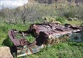 view gallery view galleryE12.4 km |  Car - Superior, AZ Car - Superior, AZ
in Abandoned Dead Vehicles This relic lies upside down below Picket Post Mountain. posted by: rjmcdonough1 location: Arizona date approved: 03/13/2020 last visited: 01/17/2021 |
|