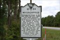
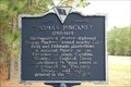
 view gallery view gallery S0 km S0 km
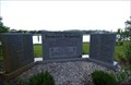
|   10-24 McClellanville 10-24 McClellanville
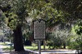
in South Carolina Historical Markers Located SE corner of US 17 and Road 1189 McClellanville, South Carolina. Erected by St. James, Santee, Historical Society-1955. posted by:  mikemtn mikemtn location: South Carolina date approved: 10/07/2006 last visited: 02/15/2024 |
 view gallery view galleryS1.8 km |  Thomson Labyrinth - McClellanvillie SC Thomson Labyrinth - McClellanvillie SC
in Labyrinths This Labyrinth is located on Venning St in McClellanville SC posted by:  nomadwillie nomadwillie location: South Carolina date approved: 10/23/2009 last visited: 05/12/2009 |
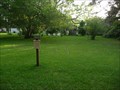
 view gallery view gallery SE1.8 km SE1.8 km
|  St. James Santee Parish WW II Memorial - McClellanville, SC St. James Santee Parish WW II Memorial - McClellanville, SC
in World War II Memorials / Monuments The St. James Santee Parish WW II Memorial is located on S. Pinckney St. in McClellanville, SC. posted by:  Lat34North Lat34North location: South Carolina date approved: 04/08/2011 last visited: 03/24/2011 |
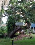 view gallery view galleryS1.8 km |  Tree House - McClellanville, SC Tree House - McClellanville, SC
in Treehouses Located in McClellanville, SC. posted by: carolina1 location: South Carolina date approved: 09/14/2008 last visited: 09/14/2008 |
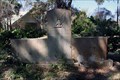
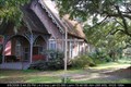 view gallery view galleryS1.8 km |  McClellanville - SC McClellanville - SC
in Churchyard Crosses The cross is located in front of the
St. Jame's Santee Episcopal Chapel of
Ease in McClellanville, SC. posted by: carolina1 location: South Carolina date approved: 09/10/2008 last visited: 04/16/2014 |
 view gallery view gallerySE2.1 km | Point Plantation - McClellanville, SC in South Carolina Historical Markers Located on S Pincknet Street (St Rd S-10-9) McClellanville, SC. posted by: Lat34North location: South Carolina date approved: 03/27/2011 last visited: 02/15/2024 |
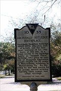 view gallery view gallerySE2.1 km | Archibald Rutledge Birthplace 10-35 - McClellanville, SC in South Carolina Historical Markers The Archibald Rutledge Birthplace historic marker is located at the intersection of Pinckney Street and Rutledge Court, McClellanville, SC. posted by: Lat34North location: South Carolina date approved: 03/31/2011 last visited: 02/15/2024 |
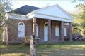
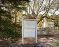 view gallery view gallerySE2.3 km |  The Village Museum at McClellanville South Carolina The Village Museum at McClellanville South Carolina
in History Museums The Village Museum is a small non-profit museum that offers exhibits featuring the local history of the St. James Santee Parish and the Village of McClellanville. The timeline includes the SeeWee Indians, the postwar farmer and the rise of the seafoo posted by: rrrparker location: South Carolina date approved: 02/19/2024 last visited: 02/15/2024 |
 view gallery view galleryS2.3 km |  Seaman's Memorial - McClellanville, SC Seaman's Memorial - McClellanville, SC
in Maritime Monuments and Memorials The Lowcountry Seaman's Memorial is located in McClellanville, SC. posted by: carolina1 location: South Carolina date approved: 09/14/2008 last visited: 09/14/2008 |
 view gallery view gallery N7.9 km N7.9 km
| St. James Santee Parish Church in South Carolina Historical Markers St. James Santee Parish Church Marker is part of the National Historic Landmarks marker series. posted by: BIO-HAZRD location: South Carolina date approved: 04/17/2014 last visited: 02/10/2016 |
 view gallery view galleryN8 km |  St. James Episcopal Church, Santee - Georgetown, South Carolina St. James Episcopal Church, Santee - Georgetown, South Carolina
in U.S. National Register of Historic Places St. James Santee Parish Church was designated a National Historic Landmark April 15, 1970. The National Register Number is #70000581. posted by: BIO-HAZRD location: South Carolina date approved: 04/20/2014 last visited: 04/16/2014 |
 view gallery view gallery NE8.9 km NE8.9 km
|  Patriot Farms - McClellanville, SC Patriot Farms - McClellanville, SC
in Pick-Your-Own Farms Patriot Farms - McClellanville, SC posted by: carolina1 location: South Carolina date approved: 08/24/2007 last visited: 08/24/2007 |
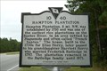 view gallery view galleryNE9.5 km | 10-40 Hampton Plantation in South Carolina Historical Markers Located on Hwy 17 North of McClellanville South Carolina. Erected by the James-Santee Historical Society-2001. posted by: mikemtn location: South Carolina date approved: 10/11/2006 last visited: 03/24/2011 |
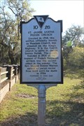
 view gallery view galleryNE10 km | 10-19 Thomas Pickney, 1750-1828 & St. James Santee in South Carolina Historical Markers Located on US 17 about 1 mile South of South Santee River Bridge. erected by St. James Santee, Parish Historical Society-1989. posted by: mikemtn location: South Carolina date approved: 10/12/2006 last visited: 04/09/2010 |
 view gallery view gallery SW10.9 km SW10.9 km
|  Buck Hall Campground Buck Hall Campground
in Campgrounds Located off of Hwy 17 North in between Awendaw, SC and McClellanville. posted by: JI Sandlappers location: South Carolina date approved: 01/04/2006 last visited: 06/27/2007 |
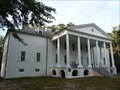 view gallery view galleryN11.6 km |  Hampton Plantation Hampton Plantation
in Wikipedia Entries Hampton Plantation, also known as Hampton Plantation House and Hampton Plantation State Historic Site is a building that evolved from a settler's home to become a Georgian style mansion. posted by: nomadwillie location: South Carolina date approved: 12/18/2009 last visited: 05/12/2009 |
 view gallery view galleryN11.6 km | Hampton Plantation - McClellanville SC in U.S. National Register of Historic Places Hampton Plantation, also known as Hampton Plantation House and Hampton Plantation State Historic Site is a building that evolved from a settler's home to become a Georgian style mansion. posted by: nomadwillie location: South Carolina date approved: 06/11/2009 last visited: 02/10/2017 |
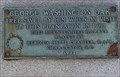 view gallery view galleryN11.6 km |  George Washington Oak Hampton Plantation S.C. George Washington Oak Hampton Plantation S.C.
in Historic Trees Large Oak saved by Washington on his trip through this area. posted by: rrrparker location: South Carolina date approved: 10/25/2018 last visited: 02/15/2017 |
 view gallery view gallery NW11.9 km NW11.9 km
| Honey Hill Campground - McClellanville, SC in Campgrounds Honey Hill Campground posted by: carolina1 location: South Carolina date approved: 08/25/2007 last visited: 08/25/2007 |
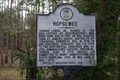 view gallery view galleryNE14.8 km | HOPSEWEE in South Carolina Historical Markers HOPSEWEE posted by: carolina1 location: South Carolina date approved: 03/24/2008 last visited: 07/20/2010 |
 view gallery view gallerySW15.3 km |  Old Tractor - Awendaw, SC Old Tractor - Awendaw, SC
in Old Tractors Steel Wheeled tractor located on US Highway 17 near Awendaw, SC. posted by: carolina1 location: South Carolina date approved: 09/05/2008 last visited: 09/06/2008 |
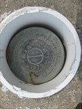 view gallery view galleryNE15.4 km |  DD0942 - 866 2793 TIDAL NSB 3 DD0942 - 866 2793 TIDAL NSB 3
in U.S. Benchmarks Located near the Oaks Plantation historic marker. posted by: ChapterhouseInc location: South Carolina date approved: 04/15/2010 last visited: 04/09/2010 |
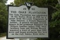 view gallery view galleryNE15.4 km | 22-50 The Oaks Plantation in South Carolina Historical Markers Located on Hy 17 South of Georgetown, South Carolina. Erected by the St. James Santee Parish Historical Soiety-1999. posted by: mikemtn location: South Carolina date approved: 10/12/2006 last visited: 04/09/2010 |
 view gallery view gallerySW22 km |  Awendaw, SC 29429 Awendaw, SC 29429
in U.S. Post Offices Post Office, Awendaw, SC. posted by: carolina1 location: South Carolina date approved: 08/24/2007 last visited: 04/09/2010 |
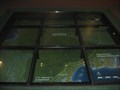 view gallery view gallerySW23.2 km |  The Sewee Visitor Center at Cape Romain NWR is where you are The Sewee Visitor Center at Cape Romain NWR is where you are
in 'You Are Here' Maps Set in the floor, this large map of the surrounding area notates where you are in relation to other destinations. posted by: ChapterhouseInc location: South Carolina date approved: 05/01/2010 last visited: 04/09/2010 |
|