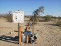
 view gallery view gallery E10.5 km E10.5 km
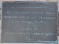
|   Pre-Columbian Trail Pre-Columbian Trail
in Signs of History This historical marker is located on the east side of California Highway 78 about 10.5 miles northeast of Glammis, California. posted by:  brwhiz brwhiz location: California date approved: 01/01/2013 last visited: 02/12/2018 |
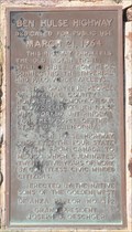 view gallery view gallery NE18 km NE18 km
| Ben Hulse Highway in Signs of History This historical marker is located on the west side of California Highway 78 about 22.5 miles southwest of Palo Verde, California. posted by: brwhiz location: California date approved: 01/01/2013 last visited: 02/12/2018 |
 view gallery view gallery SE36.2 km SE36.2 km
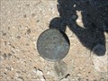
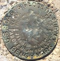
|  699 USGS - American Girl Canyon 699 USGS - American Girl Canyon
in U.S. Benchmarks U.S. Geological Survey Marker B.M. Located in the American Girl Mine area posted by:  rzrnator rzrnator location: California date approved: 04/15/2012 last visited: 02/08/2013 |
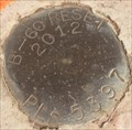
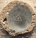
 view gallery view gallerySE40.1 km | 635 in U.S. Benchmarks Standard USGS disk set atop a pipe. posted by: rzrnator location: California date approved: 04/18/2012 last visited: 03/23/2013 |
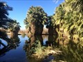
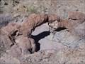 view gallery view gallerySE40.7 km |  Picacho Arch - Winterhaven, Ca. Picacho Arch - Winterhaven, Ca.
in Natural Arches Natural rock arch on the way out to Picacho State Park. posted by: bronco busters location: California date approved: 08/16/2008 last visited: 08/18/2008 |
 view gallery view gallery NW41.8 km NW41.8 km
|  Gopher Flats Golf Course Gopher Flats Golf Course
in Public and Private Golf Courses A desert golf course to satisfy those who can't wait to travel to a bigger and better course. posted by: rvjn location: California date approved: 04/06/2009 last visited: never |
 view gallery view gallery S42 km S42 km
| T16SR18E in U.S. Benchmarks US General Land Office Survey - 1915 - T16SR18E S29/S28,S32/S33 DOT posted by: philbeer location: California date approved: 06/06/2012 last visited: 02/25/2015 |
 view gallery view gallery SW42 km SW42 km
| U.S. Coast & Geodetic Survey M163 Benchmark - Holtville, CA in U.S. Benchmarks One of many benchmarks in the area. posted by: bluesnote location: California date approved: 02/02/2016 last visited: 02/02/2016 |
 view gallery view gallerySW42.2 km | B-60 Reset Mark - Holtville, CA in U.S. Benchmarks One of many benchmarks in the area. posted by: bluesnote location: California date approved: 02/02/2016 last visited: 02/02/2016 |
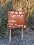
 view gallery view gallerySW42.2 km |  Holtville Hot Springs - Holtville, CA Holtville Hot Springs - Holtville, CA
in Swimming Holes A natural hot springs where one can go for a swim, in the middle of the desert. posted by: bluesnote location: California date approved: 02/05/2016 last visited: 02/11/2023 |
 view gallery view gallerySW42.2 km |  Holtville Hot Springs - Holtville, CA Holtville Hot Springs - Holtville, CA
in Hot Springs A natural hot springs where one can go for a swim, in the middle of the desert. posted by: bluesnote location: California date approved: 02/14/2016 last visited: 02/11/2023 |
 view gallery view gallerySW42.2 km |  Holtville Hot Springs - Holtville, CA Holtville Hot Springs - Holtville, CA
in Public Swimming Pools Next to the natural hot springs, water is fed through pipes to heat a small public pool at about 102 degrees. posted by: bluesnote location: California date approved: 04/13/2016 last visited: 04/13/2016 |
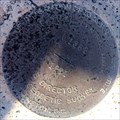
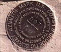 view gallery view galleryS42.3 km |  DROP DOT 1959 Azimuth Benchmark , Holtville, CA DROP DOT 1959 Azimuth Benchmark , Holtville, CA
in Azimuth Benchmarks This is the azimuth mark for triangulation station DROP, in Holtville, CA, Imperial County. posted by: Poehunters location: California date approved: 08/09/2013 last visited: 02/27/2015 |
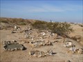
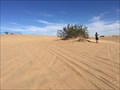 view gallery view galleryS42.3 km |  Imperial Sand Dunes - Felicity, CA Imperial Sand Dunes - Felicity, CA
in U.S. National Natural Landmarks The largest sand dunes in the state of California, is located at the Mexican Border along Interstate 8 between Yuma, Arizona and El Centro, California. The above coordinates are for the parking lot for the ranger station. posted by: bluesnote location: California date approved: 03/21/2016 last visited: 02/10/2020 |
 view gallery view galleryS42.3 km |  Imperial Sand Dunes - Felicity, CA Imperial Sand Dunes - Felicity, CA
in Metal Detecting The largest sand dunes in the state of California, is located at the Mexican Border along Interstate 8 between Yuma, Arizona and El Centro, California. The above coordinates are for the parking lot for the ranger station. posted by: bluesnote location: California date approved: 03/17/2016 last visited: 02/09/2019 |
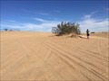 view gallery view galleryS42.3 km |  Algodones Dunes - Felicity, CA Algodones Dunes - Felicity, CA
in Wikipedia Entries The largest sand dunes in the state of California, is located at the Mexican Border along Interstate 8 between Yuma, Arizona and El Centro, California. The above coordinates are for the parking lot for the ranger station. posted by: bluesnote location: California date approved: 03/18/2016 last visited: 02/10/2020 |
 view gallery view galleryS42.3 km |  Imperial Sand Dunes - Felicity, CA Imperial Sand Dunes - Felicity, CA
in Official Local Tourism Attractions The largest sand dunes in the state of California, is located at the Mexican Border along Interstate 8 between Yuma, Arizona and El Centro, California. The above coordinates are for the parking lot for the ranger station. posted by: bluesnote location: California date approved: 03/18/2016 last visited: 02/10/2020 |
 view gallery view galleryS42.3 km |  Grays Well Outhouses - Felicity, CA Grays Well Outhouses - Felicity, CA
in Outhouses Grays Wells Rest Stop on I-8 West of Yuma, AZ (at the Sand-Hills) posted by:  GIDEON-X GIDEON-X location: California date approved: 08/20/2008 last visited: 02/12/2018 |
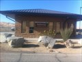
 view gallery view galleryS42.3 km |  Gray Wells Rest Stop - Felicity, CA Gray Wells Rest Stop - Felicity, CA
in Free Overnight RV Parking Locations A small rest area in the middle of Interstate 8, surrounded by large sand dunes. posted by: bluesnote location: California date approved: 02/20/2016 last visited: 02/20/2016 |
 view gallery view galleryS42.3 km |  Gray Wells Rest Stop - Felicity, CA Gray Wells Rest Stop - Felicity, CA
in Highway Rest Areas A small rest area in the middle of Interstate 8, surrounded by large sand dunes. posted by: bluesnote location: California date approved: 02/04/2016 last visited: 02/04/2016 |
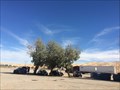
 view gallery view galleryS42.3 km |  Buttercup Ranger Station - Winterhaven, CA Buttercup Ranger Station - Winterhaven, CA
in Ranger Stations This ranger station is located at Royal Dunes Park. posted by: bluesnote location: California date approved: 12/22/2013 last visited: 02/09/2019 |
 view gallery view galleryNW42.8 km |  The Slabs Pet Cemetery, Niland, CA The Slabs Pet Cemetery, Niland, CA
in Pet Cemeteries A desert cemetery developed by and for RVing Snowbirds who were forced to leave behind their pets. posted by: rvjn location: California date approved: 04/10/2009 last visited: never |
 view gallery view galleryS43 km | National Geodetic Survey Q1362 Vertical Control Mark - Felicity, CA in U.S. Benchmarks One of many benchmarks on old U.S. 98, just west of Yuma. posted by: bluesnote location: California date approved: 05/09/2016 last visited: 05/09/2016 |
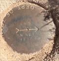
 view gallery view galleryS43 km | CalTrans End Triangulation Station Disk - Felicity, CA in U.S. Benchmarks One of many benchmarks on old U.S. 98, just west of Yuma. posted by: bluesnote location: California date approved: 02/02/2016 last visited: 02/02/2016 |
 view gallery view galleryS43 km | CalTrans End Reference Mark No. 1 - Felicity, CA in U.S. Benchmarks One of many benchmarks on old U.S. 98, just west of Yuma. posted by: bluesnote location: California date approved: 02/02/2016 last visited: 02/02/2016 |
|