 view gallery view gallery SE4.7 km SE4.7 km
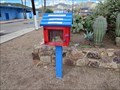
|   Little Free Library 21393 - Winkelman, AZ Little Free Library 21393 - Winkelman, AZ
in Free Community Book Exchanges This Little Free Library is in the parking lot of the Hayden High School in Winkelman, Arizona. posted by:  rjmcdonough1 rjmcdonough1 location: Arizona date approved: 10/19/2018 last visited: never |
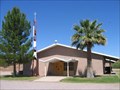
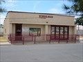 view gallery view gallerySE4.7 km |  Winkelman, AZ Winkelman, AZ
in City and Town Halls This town hall is a simple, single story structure. posted by: rjmcdonough1 location: Arizona date approved: 07/02/2019 last visited: never |
 view gallery view gallerySE4.8 km |  Winkelman Bridge - Winkelman, AZ Winkelman Bridge - Winkelman, AZ
in U.S. National Register of Historic Places The Winkelman Bridge originally carried AZ Hwy. 77 over the Gila River. posted by: rjmcdonough1 location: Arizona date approved: 10/18/2018 last visited: never |
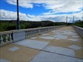 view gallery view gallerySE4.8 km |  Winkelman Bridge - Winkelman, AZ Winkelman Bridge - Winkelman, AZ
in Orphaned Bridges The Winkelman Bridge originally carried AZ Hwy. 77 over the Gila River into the center of Winkelman. posted by: rjmcdonough1 location: Arizona date approved: 10/17/2018 last visited: never |
 view gallery view gallerySE4.8 km |  Winkelman Bridge - Winkelman, AZ Winkelman Bridge - Winkelman, AZ
in Arch Bridges The Winkelman Bridge originally carried AZ Hwy. 77 over the Gila River. posted by: rjmcdonough1 location: Arizona date approved: 10/21/2018 last visited: 07/12/2021 |
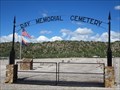 view gallery view gallery NW8.5 km NW8.5 km
|  Ray Memorial Cemetery - Kearny, AZ Ray Memorial Cemetery - Kearny, AZ
in Worldwide Cemeteries The Ray Memorial Cemetery was established to contain the remains from older cemeteries displaced by the Ray Strip Mine. posted by: rjmcdonough1 location: Arizona date approved: 10/16/2018 last visited: never |
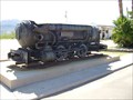 view gallery view galleryNW10 km |  Porter Air Locomotive - Kearny, AZ Porter Air Locomotive - Kearny, AZ
in Locomotives This locomotive is a gift to the citizens of Kearny, Arizona, by the Kennecott Copper Corporation. posted by:  leadhiker leadhiker location: Arizona date approved: 06/06/2011 last visited: 08/28/2022 |
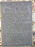 view gallery view galleryNW10 km |  Kearny, Arizona Kearny, Arizona
in Arizona Historical Markers Named in Honor of Stephen Watts Kearny
— Brevet Major General U.S. Army — posted by: leadhiker location: Arizona date approved: 06/07/2011 last visited: 10/16/2018 |
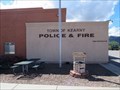 view gallery view galleryNW10.1 km |  Police Department - Kearny, AZ Police Department - Kearny, AZ
in Police Stations This building houses the Police Department for the town of Kearny. posted by: rjmcdonough1 location: Arizona date approved: 11/07/2018 last visited: never |
 view gallery view galleryNW10.1 km |  Kearny, Arizona Kearny, Arizona
in Wikipedia Entries Kearny is a town constructed by Kennecott Copper Company to house employees. It is located in eastern Arizona. posted by: rjmcdonough1 location: Arizona date approved: 10/21/2018 last visited: never |
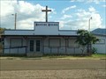 view gallery view gallery NE12.6 km NE12.6 km
|  Country Church outside Winkelman, AZ Country Church outside Winkelman, AZ
in Country Churches This is a country church located along Hwy 77 way outside Winkelman, AZ. posted by: Poehunters location: Arizona date approved: 08/13/2013 last visited: 08/12/2013 |
 view gallery view gallery W17.2 km W17.2 km
|  Cell Tower Grove...of 2 Cell Tower Grove...of 2
in Disguised Cell Towers They began as one. Now they are 2. When will there be more? posted by:  Tsegi Mike and Desert Viking Tsegi Mike and Desert Viking location: Arizona date approved: 11/14/2005 last visited: never |
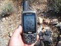 view gallery view galleryW17.2 km |  N 33 W 111 - Pinal County, AZ N 33 W 111 - Pinal County, AZ
in Confluence Spots This is the confluence of N 33° and W 111°. posted by: TucsonThompsen location: Arizona date approved: 06/08/2010 last visited: never |
 view gallery view galleryNW20.3 km |  ASARCO Grupo Mexico Ray Mine - Kearny, AZ ASARCO Grupo Mexico Ray Mine - Kearny, AZ
in Mines This is an open pit copper mine northwest of Kearny, Arizona. posted by: rjmcdonough1 location: Arizona date approved: 10/16/2018 last visited: never |
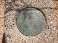
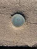 view gallery view galleryW21.1 km |  Wolley - Arizona - DU2052 Wolley - Arizona - DU2052
in U.S. Benchmarks Benchmark DU2052 on the Florence-Kelvin road in Pinal County, Arizona.
Triangulation station disk, set into the top of a square, with rounded corners concrete monument. posted by: T2D location: Arizona date approved: 11/29/2020 last visited: never |
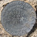 view gallery view galleryW22 km |  WOLLEY - Arizona WOLLEY - Arizona
in Azimuth Benchmarks Azimuth marker associated with Benchmark DU2052 and two reference markers on the Florence-Kelvin road in Pinal County, Arizona. posted by: tugies location: Arizona date approved: 10/08/2014 last visited: 10/08/2014 |
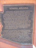 view gallery view galleryNW24.6 km | Sonora, Arizona in Arizona Historical Markers Sonora was demolished to make way for the open-pit mine that Kennecott Copper Company started about 1958. posted by: leadhiker location: Arizona date approved: 12/20/2010 last visited: never |
 view gallery view gallery N28.5 km N28.5 km
| El Capitan Pass in Arizona Historical Markers Pass that Gen. Kearny used to take his army to California in 1846. posted by: Dalphin location: Arizona date approved: 02/28/2010 last visited: 02/25/2010 |
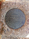 view gallery view galleryW29.9 km | USGS 5DM 1963 Benchmark in U.S. Benchmarks USGS 5DM 1963 Benchmark Elevation 2672 Feet Above Sea posted by: tincanbits location: Arizona date approved: 09/20/2013 last visited: 02/08/2014 |
 view gallery view gallerySE35.2 km | Blessed Sacrament Church - Mammoth, AZ in Roman Catholic Churches A Catholic Church located along W Church Drive. posted by: HiFiLZ location: Arizona date approved: 05/27/2008 last visited: 05/17/2008 |
 view gallery view galleryW35.7 km | USGS 3DM 1963 Benchmark in U.S. Benchmarks USGS 3DM 1963 Benchmark Elevation 2344 Feet Above Sea posted by: tincanbits location: Arizona date approved: 09/15/2013 last visited: 06/05/2017 |
 view gallery view galleryN36.5 km | ") Pinal Mountain Mine Shaft - Miami, AZ Pinal Mountain Mine Shaft - Miami, AZ
in Cave Entrances (Artificial) This old mine opening is now a bat cave. posted by: rjmcdonough1 location: Arizona date approved: 06/04/2019 last visited: 05/24/2020 |
 view gallery view galleryNW40.7 km | Fairview Cemetery - Superior, Arizona, USA in Worldwide Cemeteries Located in the town of Superior, Arizona, the cemetery consists of 30 acres. posted by: Tsegi Mike and Desert Viking location: Arizona date approved: 09/20/2011 last visited: 08/27/2019 |
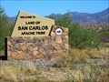 view gallery view galleryN40.7 km |  San Carlos Indian Reservation, Apache - Arizona, USA San Carlos Indian Reservation, Apache - Arizona, USA
in Nations Within Nations This reservation is east of Globe, Arizona. posted by: rjmcdonough1 location: Arizona date approved: 07/06/2018 last visited: never |
 view gallery view galleryNW40.7 km | Devil's Canyon Bridge - Superior, AZ USA in Arch Bridges The Devils Canyon Bridge carried an old alignment of the U.S. 60 across the creek bed as the highway travelled between Superior and Miami Arizona. posted by: rjmcdonough1 location: Arizona date approved: 03/31/2023 last visited: never |
|