  E5.3 km E5.3 km
|   Cedar Creek Falls Cedar Creek Falls
in Swimming Holes A popular swimming hole near Ramona. posted by:  Toby's Gang Toby's Gang location: California date approved: 09/07/2005 last visited: 11/09/2009 |
 view gallery view gallery N7.1 km N7.1 km
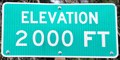
|  Old Julian Highway ~ Elevation 2000 Feet Old Julian Highway ~ Elevation 2000 Feet
in Elevation Signs This Elevation Sign is on the east side of the Old Julian Highway (California Highway 78) just south of Rancho Santa Fe Court, about 4.7 miles northeast of Ramona, California. posted by: brwhiz location: California date approved: 12/10/2012 last visited: 08/14/2016 |
 view gallery view gallery NW8.5 km NW8.5 km
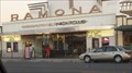
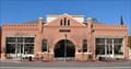
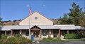
|  Ramona Mainstage - Ramona, California Ramona Mainstage - Ramona, California
in Concert Halls Ramona Mainstage is a multipurpose building on the main drag in Ramona whose history goes back over 70 years. posted by: =CCC= location: California date approved: 08/03/2016 last visited: 08/04/2016 |
 view gallery view galleryNW8.5 km |  Verlaque House - E Clampus Vitus - Ramona, CA Verlaque House - E Clampus Vitus - Ramona, CA
in E Clampus Vitus Historical Markers This ECV marker dedicates an adobe home of a Ramona pioneer. posted by:  Johnny_Quest Johnny_Quest location: California date approved: 01/29/2012 last visited: 12/27/2010 |
 view gallery view galleryNW8.5 km |  Verlaque, Theophile, House - Ramona, California Verlaque, Theophile, House - Ramona, California
in U.S. National Register of Historic Places The Theophile Verlaque House was added to the National Register of Historic Places on August 7, 1991. posted by: brwhiz location: California date approved: 01/20/2011 last visited: never |
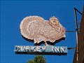 view gallery view galleryNW8.5 km |  Turkey Inn - Ramona, CA Turkey Inn - Ramona, CA
in Neon Signs Neon sign outside the Turkey Inn Tavern in Ramona, CA. posted by: Johnny_Quest location: California date approved: 06/04/2010 last visited: 04/25/2012 |
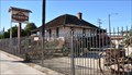
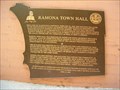 view gallery view galleryNW8.7 km | Ramona Town Hall - Ramona, CA in E Clampus Vitus Historical Markers ECV plaque on the front of Ramona's Historic Town Hall. posted by: Johnny_Quest location: California date approved: 06/01/2010 last visited: 12/27/2010 |
 view gallery view galleryNW8.7 km | Ramona Town Hall ~ Ramona, California in U.S. National Register of Historic Places The Ramona Town Hall, also known as Barnett Hall or Town Hall of Nuevo, was added to the National Register of Historic Places on September 6, 1994. posted by: brwhiz location: California date approved: 01/20/2011 last visited: never |
 view gallery view gallery W9.3 km W9.3 km
|  Ramona, California 92065 Ramona, California 92065
in U.S. Post Offices This Post Office is located at 1444 Main Street in Ramona, California. posted by: brwhiz location: California date approved: 11/09/2011 last visited: never |
 view gallery view gallery SW11.1 km SW11.1 km
|  Barona Valley Ranch Resort & Casino Barona Valley Ranch Resort & Casino
in Casinos Located just 30 minutes outside of San Diego, Barona offers gaming action, unique dining, a hotel, and world-class golf. With a history dating back to the 1930s when the Barona Tribe established a small ranching community, the Barona Reservation has now blossomed into one of "California’s best casino's". posted by: PassingWind location: California date approved: 08/16/2005 last visited: 02/20/2013 |
 view gallery view gallerySW11.3 km |  Rumely Oilpull Tractor, Ramona, CA Rumely Oilpull Tractor, Ramona, CA
in Old Tractors This is a Rumely Oilpull tractor located at the Barona Casino on the Barona Indian Reservation in Ramona, CA. posted by: Johnny_Quest location: California date approved: 10/21/2007 last visited: never |
 view gallery view gallery S12.6 km S12.6 km
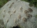
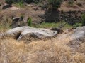
|  Grinding Holes - El Cap Reservoir Grinding Holes - El Cap Reservoir
in New World Ancient Evidence Grinding holes by El Cap Reservoir. posted by: zatyko location: California date approved: 03/04/2012 last visited: 03/05/2012 |
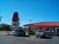 view gallery view galleryW14.6 km |  Arby's - Woodside Ave. -Lakeside -CA Arby's - Woodside Ave. -Lakeside -CA
in Arby's Restaurants Arby's Restaurant in Lakeside, CA. posted by: Johnny_Quest location: California date approved: 01/26/2008 last visited: 04/23/2011 |
 view gallery view gallery NE15.1 km NE15.1 km
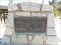
|  Inaja Forest Firefighter Memorial - Santa Ysabel, CA Inaja Forest Firefighter Memorial - Santa Ysabel, CA
in Firefighter Memorials A small memorial plaque is placed at the entrance to a park. posted by: bluesnote location: California date approved: 08/12/2015 last visited: 09/05/2019 |
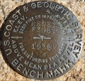 view gallery view galleryNE15.1 km |  U.S. Coast & Geodetic Survey F308 RESET Benchmark - Santa Ysabel, CA U.S. Coast & Geodetic Survey F308 RESET Benchmark - Santa Ysabel, CA
in U.S. Benchmarks A benchmark placed next to a memorial at a scenic overlook along Highway 79. posted by: bluesnote location: California date approved: 08/10/2015 last visited: 08/10/2015 |
 view gallery view galleryS15.1 km | Ancient Evidence with a View in New World Ancient Evidence This is on a ridge containing multiple bedrock mortars. posted by: fisnjack location: California date approved: 10/08/2006 last visited: never |
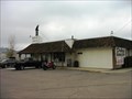 view gallery view galleryNE15.3 km |  Dudley's Bakery, Santa Ysabel, CA Dudley's Bakery, Santa Ysabel, CA
in Independent Bakeries Dudley's Bakery, Santa Ysabel, CA
posted by: michael3900 location: California date approved: 09/25/2008 last visited: 01/10/1978 |
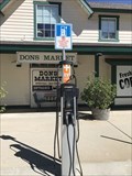 view gallery view galleryNE15.3 km |  Don's Market Chargers - Santa Ysabel, CA Don's Market Chargers - Santa Ysabel, CA
in Electric Car Charging Stations A set of car chargers in a small rural town. posted by: bluesnote location: California date approved: 08/10/2015 last visited: 08/10/2015 |
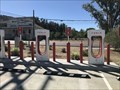 view gallery view galleryNE15.3 km | Tesla Chargers - Santa Ysabel, CA, USA in Electric Car Charging Stations A series of Tesla chargers in Santa Ysabel, California. posted by: bluesnote location: California date approved: 08/31/2022 last visited: never |
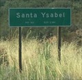 view gallery view galleryNE15.3 km |  Santa Ysabel, California Santa Ysabel, California
in American Guide Series A small unincorporated town in San Diego County. posted by: bluesnote location: California date approved: 05/02/2016 last visited: 05/02/2016 |
 view gallery view galleryNE15.3 km |  Santa Ysabel, California Santa Ysabel, California
in Wikipedia Entries A small unincorporated town in San Diego County. posted by: bluesnote location: California date approved: 08/10/2015 last visited: 08/10/2015 |
 view gallery view galleryNE15.4 km | Santa Ysabel, California 92070 in U.S. Post Offices This Post Office is located at 21977 Highway 79 in Santa Ysabel, California. posted by: brwhiz location: California date approved: 11/09/2011 last visited: 09/29/2021 |
 view gallery view galleryNE15.4 km | Santa Ysabel, California ~ Elevation 2,984 in Elevation Signs An elevation / population sign along Highway 79. posted by: bluesnote location: California date approved: 08/11/2015 last visited: 08/11/2015 |
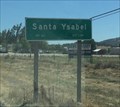 view gallery view galleryNE15.4 km |  Santa Ysabel, California ~ Population 463 Santa Ysabel, California ~ Population 463
in Population Signs An elevation / population sign along Highway 79. posted by: bluesnote location: California date approved: 08/11/2015 last visited: 08/11/2015 |
 view gallery view galleryNE15.6 km | Santa Ysabel, California ~ Population 463 in Population Signs An elevation / population sign along Highway 79. posted by: bluesnote location: California date approved: 08/11/2015 last visited: 08/11/2015 |
|