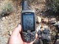
 view gallery view gallery N1.4 km N1.4 km
|   Winkelman Bridge - Winkelman, AZ Winkelman Bridge - Winkelman, AZ
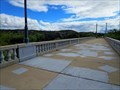
in U.S. National Register of Historic Places The Winkelman Bridge originally carried AZ Hwy. 77 over the Gila River. posted by:  rjmcdonough1 rjmcdonough1 location: Arizona date approved: 10/18/2018 last visited: never |
 view gallery view galleryN1.4 km |  Winkelman Bridge - Winkelman, AZ Winkelman Bridge - Winkelman, AZ
in Orphaned Bridges The Winkelman Bridge originally carried AZ Hwy. 77 over the Gila River into the center of Winkelman. posted by: rjmcdonough1 location: Arizona date approved: 10/17/2018 last visited: never |
 view gallery view galleryN1.4 km |  Winkelman Bridge - Winkelman, AZ Winkelman Bridge - Winkelman, AZ
in Arch Bridges The Winkelman Bridge originally carried AZ Hwy. 77 over the Gila River. posted by: rjmcdonough1 location: Arizona date approved: 10/21/2018 last visited: 07/12/2021 |
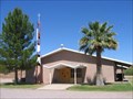
 view gallery view galleryN1.8 km |  Winkelman, AZ Winkelman, AZ
in City and Town Halls This town hall is a simple, single story structure. posted by: rjmcdonough1 location: Arizona date approved: 07/02/2019 last visited: never |
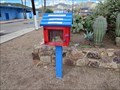 view gallery view galleryN2.1 km |  Little Free Library 21393 - Winkelman, AZ Little Free Library 21393 - Winkelman, AZ
in Free Community Book Exchanges This Little Free Library is in the parking lot of the Hayden High School in Winkelman, Arizona. posted by: rjmcdonough1 location: Arizona date approved: 10/19/2018 last visited: never |
 view gallery view gallery NW14 km NW14 km
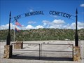
|  Ray Memorial Cemetery - Kearny, AZ Ray Memorial Cemetery - Kearny, AZ
in Worldwide Cemeteries The Ray Memorial Cemetery was established to contain the remains from older cemeteries displaced by the Ray Strip Mine. posted by: rjmcdonough1 location: Arizona date approved: 10/16/2018 last visited: never |
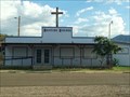 view gallery view galleryN14.2 km |  Country Church outside Winkelman, AZ Country Church outside Winkelman, AZ
in Country Churches This is a country church located along Hwy 77 way outside Winkelman, AZ. posted by: Poehunters location: Arizona date approved: 08/13/2013 last visited: 08/12/2013 |
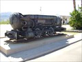 view gallery view galleryNW15.4 km |  Porter Air Locomotive - Kearny, AZ Porter Air Locomotive - Kearny, AZ
in Locomotives This locomotive is a gift to the citizens of Kearny, Arizona, by the Kennecott Copper Corporation. posted by:  leadhiker leadhiker location: Arizona date approved: 06/06/2011 last visited: 08/28/2022 |
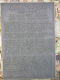 view gallery view galleryNW15.4 km |  Kearny, Arizona Kearny, Arizona
in Arizona Historical Markers Named in Honor of Stephen Watts Kearny
— Brevet Major General U.S. Army — posted by: leadhiker location: Arizona date approved: 06/07/2011 last visited: 10/16/2018 |
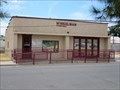
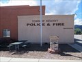 view gallery view galleryNW15.6 km |  Police Department - Kearny, AZ Police Department - Kearny, AZ
in Police Stations This building houses the Police Department for the town of Kearny. posted by: rjmcdonough1 location: Arizona date approved: 11/07/2018 last visited: never |
 view gallery view galleryNW15.6 km |  Kearny, Arizona Kearny, Arizona
in Wikipedia Entries Kearny is a town constructed by Kennecott Copper Company to house employees. It is located in eastern Arizona. posted by: rjmcdonough1 location: Arizona date approved: 10/21/2018 last visited: never |
 view gallery view gallery W21.1 km W21.1 km
|  N 33 W 111 - Pinal County, AZ N 33 W 111 - Pinal County, AZ
in Confluence Spots This is the confluence of N 33° and W 111°. posted by: TucsonThompsen location: Arizona date approved: 06/08/2010 last visited: never |
 view gallery view galleryW21.1 km |  Cell Tower Grove...of 2 Cell Tower Grove...of 2
in Disguised Cell Towers They began as one. Now they are 2. When will there be more? posted by:  Tsegi Mike and Desert Viking Tsegi Mike and Desert Viking location: Arizona date approved: 11/14/2005 last visited: never |
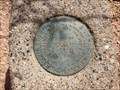
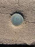 view gallery view galleryW25.6 km |  Wolley - Arizona - DU2052 Wolley - Arizona - DU2052
in U.S. Benchmarks Benchmark DU2052 on the Florence-Kelvin road in Pinal County, Arizona.
Triangulation station disk, set into the top of a square, with rounded corners concrete monument. posted by: T2D location: Arizona date approved: 11/29/2020 last visited: never |
 view gallery view galleryNW25.7 km |  ASARCO Grupo Mexico Ray Mine - Kearny, AZ ASARCO Grupo Mexico Ray Mine - Kearny, AZ
in Mines This is an open pit copper mine northwest of Kearny, Arizona. posted by: rjmcdonough1 location: Arizona date approved: 10/16/2018 last visited: never |
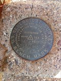
 view gallery view galleryW26.6 km |  WOLLEY - Arizona WOLLEY - Arizona
in Azimuth Benchmarks Azimuth marker associated with Benchmark DU2052 and two reference markers on the Florence-Kelvin road in Pinal County, Arizona. posted by: tugies location: Arizona date approved: 10/08/2014 last visited: 10/08/2014 |
 view gallery view gallery SE29.9 km SE29.9 km
| Blessed Sacrament Church - Mammoth, AZ in Roman Catholic Churches A Catholic Church located along W Church Drive. posted by: HiFiLZ location: Arizona date approved: 05/27/2008 last visited: 05/17/2008 |
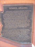 view gallery view galleryNW30.3 km | Sonora, Arizona in Arizona Historical Markers Sonora was demolished to make way for the open-pit mine that Kennecott Copper Company started about 1958. posted by: leadhiker location: Arizona date approved: 12/20/2010 last visited: never |
 view gallery view galleryN32.3 km | El Capitan Pass in Arizona Historical Markers Pass that Gen. Kearny used to take his army to California in 1846. posted by: Dalphin location: Arizona date approved: 02/28/2010 last visited: 02/25/2010 |
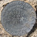
 view gallery view galleryW33.3 km | USGS 5DM 1963 Benchmark in U.S. Benchmarks USGS 5DM 1963 Benchmark Elevation 2672 Feet Above Sea posted by: tincanbits location: Arizona date approved: 09/20/2013 last visited: 02/08/2014 |
 view gallery view galleryW39.3 km | USGS 3DM 1963 Benchmark in U.S. Benchmarks USGS 3DM 1963 Benchmark Elevation 2344 Feet Above Sea posted by: tincanbits location: Arizona date approved: 09/15/2013 last visited: 06/05/2017 |
 view gallery view gallery S39.4 km S39.4 km
|  Ghost Bike - Oracle, AZ Ghost Bike - Oracle, AZ
in Ghost Bikes Ghost bike located near Oracle, AZ on the south side of Highway 77 at mile marker 99.6 posted by: T2D location: Arizona date approved: 08/29/2022 last visited: never |
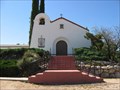 view gallery view galleryS40.1 km | St. Helen's Mission Church - Oracle, AZ in Roman Catholic Churches A historic Catholic Mission Church located near the intersection of W American Ave & Maplewood Dr. posted by: HiFiLZ location: Arizona date approved: 05/27/2008 last visited: 03/19/2011 |
 view gallery view galleryS40.2 km | All Saint's Church - Oracle, AZ in U.S. National Register of Historic Places The All Saints Church was built in 1901. This building was placed on the National Register of Historical Places on May 3, 1984. posted by: leadhiker location: Arizona date approved: 05/25/2010 last visited: 08/28/2022 |
 view gallery view galleryS40.2 km | Acadia Ranch - Oracle AZ in U.S. National Register of Historic Places Today the Acadia Ranch serves as a museum devoted to the Oracle area's rich history, as well as the headquarters of the Oracle Historical Society. posted by: leadhiker location: Arizona date approved: 05/25/2010 last visited: never |
|