 view gallery view gallery N8.4 km N8.4 km
|   Old Rock Jail - Rockford, AL Old Rock Jail - Rockford, AL
in Alabama Historical Markers Located at the corner of Alabama Highway 22 and Jackson St., this marker notes the old brick stone jail as the oldest one in Alabama. posted by:  hoteltwo hoteltwo location: Alabama date approved: 04/09/2019 last visited: 06/24/2023 |
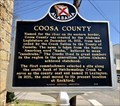 view gallery view galleryN8.4 km | Coosa County - Rockford, AL in Alabama Historical Markers Rockford, where this marker is located, is the County Seat of Coosa County. The marker is just west of the County Courthouse on Alabama Highway 22. posted by: hoteltwo location: Alabama date approved: 04/09/2019 last visited: 06/24/2023 |
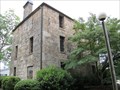 view gallery view galleryN8.4 km |  Coosa County Jail - Rockford, AL Coosa County Jail - Rockford, AL
in U.S. National Register of Historic Places Old Coosa County Jail posted by: wmize location: Alabama date approved: 05/16/2011 last visited: 06/24/2023 |
 view gallery view gallery SW14.3 km SW14.3 km
|  Titus, Alabama 36080 Titus, Alabama 36080
in U.S. Post Offices Post Office is located in a very rural unincorporated community of Titus, Alabama at 5999 Titus Road. posted by: hoteltwo location: Alabama date approved: 03/22/2014 last visited: never |
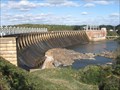
 view gallery view gallery W20.4 km W20.4 km
|  Mitchell Hydroelectric Generating Plant - Verbena, AL, US Mitchell Hydroelectric Generating Plant - Verbena, AL, US
in Hydroelectric Power Stations Located on the Coosa River, near a location called Duncan's Riffle, the hydroelectric plant, straddles the Chilton and Coosa County line. It houses, as part of the Mitchell Dam, the 2nd oldest of Alabama Power Company's hydroelectric plants. posted by: hoteltwo location: Alabama date approved: 03/24/2014 last visited: never |
 view gallery view galleryW20.4 km |  Mitchell Dam - Verbena, Alabama Mitchell Dam - Verbena, Alabama
in Water Dams Located on the Coosa River near a location called Duncan's Riffle, the dam straddles the Chilton and Coosa County line. It houses the 2nd oldest of Alabama Power Company's hydroelectric plants. posted by: hoteltwo location: Alabama date approved: 03/25/2014 last visited: never |
 view gallery view gallery S21.2 km S21.2 km
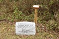
|  Identification markers for Swayback Bridge Trails Identification markers for Swayback Bridge Trails
in Eagle Scout Project Sites Eagle Scout project which placed identification markers along the Swayback Bridge Trail. Markers identify plants and also animal tracks one might encounter along the trail. posted by:  OHail OHail location: Alabama date approved: 01/19/2012 last visited: never |
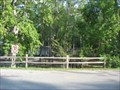
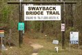 view gallery view galleryS21.2 km |  Swayback Bridge Biking and Hiking Trails Swayback Bridge Biking and Hiking Trails
in Mountain Bike Trailheads Trailhead of the Swayback Bridge trails near Lake Jordan. Trails are for hikers and bicyclists. posted by: OHail location: Alabama date approved: 01/20/2012 last visited: 01/19/2012 |
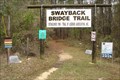 view gallery view galleryS21.2 km |  Swayback Bridge Trail Swayback Bridge Trail
in Hiking and walking trailheads Trailhead of the Swayback Bridge trails near Lake Jordan. Trails are for hikers and bicyclists. posted by: OHail location: Alabama date approved: 01/19/2012 last visited: 01/19/2012 |
 view gallery view galleryS21.2 km | Directional arrows and signs for Swayback Bridge Trails in Eagle Scout Project Sites Eagle Scout Project which provided directional arrows and signs for the Swayback Bridge Trails. posted by: OHail location: Alabama date approved: 01/19/2012 last visited: never |
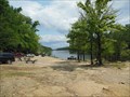
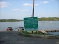 view gallery view galleryW21.6 km |  Lake Mitchell Public Boat Ramp Lake Mitchell Public Boat Ramp
in Boat Ramps Public boat launch for beautiful Lake Mitchell in central Alabama. posted by: Lazer location: Alabama date approved: 09/17/2007 last visited: never |
 view gallery view galleryW21.7 km |  Higgins Ferry Park - Chilton County, AL Higgins Ferry Park - Chilton County, AL
in Municipal Parks and Plazas A park located on the edge of beautiful Lake Mitchell in central Alabama. posted by: Lazer location: Alabama date approved: 09/21/2007 last visited: never |
 view gallery view gallerySW21.9 km | Holtville School - Holtville, AL in Alabama Historical Markers Provides the early history of the many accomplishments of this award winning school located on Alabama Highway 111 in Holtville. posted by: hoteltwo location: Alabama date approved: 01/08/2014 last visited: never |
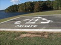 view gallery view galleryS21.9 km |  Jordan Dam Helipad - Wetumpka, AL Jordan Dam Helipad - Wetumpka, AL
in Helicopter Landing Pads This helipad is located in a grassy area on the east side of the Jordan Dam. It is marked for private use. posted by: xptwo location: Alabama date approved: 01/17/2013 last visited: never |
 view gallery view galleryS22 km | Jordan Hydroelectric Generating Plant - Wetumpka, AL in Hydroelectric Power Stations The Alabama Power Company began work on Jordan Dam in 1926. It began service on December 31, 1928, providing hydroelectric power to the state of Alabama as part of a series of stations built in the early part of the 20th Century. posted by: xptwo location: Alabama date approved: 11/04/2012 last visited: never |
 view gallery view galleryS22 km | Jordan Dam - Wetumpka, AL in Water Dams The Alabama Power Company began work on Jordan Dam in 1926. It began service on December 31, 1928, providing hydroelectric power to the state of Alabama as part of a series of dams built in the early part of the 20th Century. posted by: xptwo location: Alabama date approved: 11/06/2012 last visited: never |
 view gallery view galleryS22.4 km |  Coosa River - Wetumpka, AL Coosa River - Wetumpka, AL
in Canoe/Kayak Trips There is a public launch point for canoes and kayaks just below the Jordan River Dam. The trip has some easier rapids and can go as far as Wetumpka. posted by: xptwo location: Alabama date approved: 05/30/2013 last visited: never |
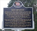 view gallery view gallery NE23.8 km NE23.8 km
| Socopatoy - Kellyton, AL in Alabama Historical Markers In the early 1800s, Socopatoy included a Native American village, frontier fort, and pioneer town. posted by: hummerstation location: Alabama date approved: 08/05/2016 last visited: never |
 view gallery view gallerySW23.8 km |  Opelika Depot CM0652 - Opelika, AL Opelika Depot CM0652 - Opelika, AL
in U.S. Benchmarks This benchmark is embedded in the wall on the track side of the old Opelika Depot, which has been restored and is used by The Arts Association of East Alabama. posted by: xptwo location: Alabama date approved: 07/24/2013 last visited: never |
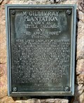 view gallery view galleryS24 km | McGillivray Plantation - Near Wetumpka, AL in Alabama Historical Markers By the mid-1740s, McGillivray was well established as a fur trader and established a fur trading post and plantation at Little Tallassee (aka Little Tallase) near today's Wetumpka. posted by: hoteltwo location: Alabama date approved: 03/12/2024 last visited: never |
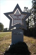 view gallery view gallery SE24.1 km SE24.1 km
|  Eclectic (Alabama)- Star of Elmore County Eclectic (Alabama)- Star of Elmore County
in Welcome Signs Welcome to Eclectic sign as one is traveling south into town from Lake Martin on AL 63. posted by: OHail location: Alabama date approved: 12/14/2011 last visited: 06/10/2021 |
 view gallery view gallerySW24.5 km |  West Holtville Alabama Water Tank West Holtville Alabama Water Tank
in Water Towers Fairly new water tower far out in the country. posted by: HotRod205 location: Alabama date approved: 09/12/2010 last visited: 08/04/2011 |
 view gallery view gallerySE25.1 km | Star of Elmore County - Eclectic, Alabama in Welcome Signs The Welcome to Eclectic "Star of Elmore County" is one of five such signs. This one is located on Highway 170 and can be seen as one heads north toward the town. posted by: xptwo location: Alabama date approved: 12/17/2011 last visited: never |
 view gallery view gallerySE25.1 km |  Star of Elmore County - Eclectic, Alabama Star of Elmore County - Eclectic, Alabama
in Artistic Welcome Signs The Welcome to Eclectic "Star of Elmore County" sign incorporates their slogan and their history as the place where "stars fell on Alabama." posted by: xptwo location: Alabama date approved: 12/19/2011 last visited: 12/25/2011 |
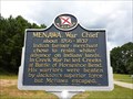 view gallery view gallery E25.4 km E25.4 km
| Menawa, War Chief - Alexander City, AL in Alabama Historical Markers Marker located near the entrance to Wind Creek State Park, describes the Indian warrior Menawa. posted by: hoteltwo location: Alabama date approved: 08/23/2013 last visited: 03/14/2015 |
|