 view gallery view gallery NE0.6 km NE0.6 km
|   Eagle Eye Views in Madeira Eagle Eye Views in Madeira
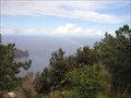
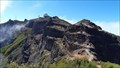
in Scenic Hikes A three hour energetic hike which takes you to a geodesic mark on the highest point of Penha de Aguia where you can enjoy scenic views. posted by:  patanddave patanddave location: Arquipélago da Madeira, Portugal date approved: 02/17/2006 last visited: 02/05/2015 |
 view gallery view gallery NW1.3 km NW1.3 km
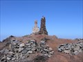
|  Miradouro, Faial, Madeira Miradouro, Faial, Madeira
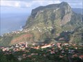
in Scenic Roadside Look-Outs There is an excellent scenic viewpoint giving views of the town of Faial and Eagle Rock (Penha do Aguia) along the rugged north east coast of Madeira. posted by:  arby101ca arby101ca location: Arquipélago da Madeira, Portugal date approved: 12/03/2010 last visited: 02/05/2015 |
 view gallery view gallery SE1.4 km SE1.4 km
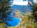
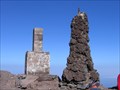
|  Penha D'aguia Penha D'aguia
in Mountain Summits [PT]
Penha d'aguia, um rochedo com 590m de altura que oferece uma vista esplendorosa.
[ENG]
Penha d aguia, a rock with 590 m in height that offers a splendid view posted by: RRV1982 location: Arquipélago da Madeira, Portugal date approved: 09/26/2014 last visited: 04/10/2018 |
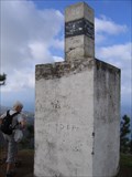 view gallery view galleryNW3.1 km |  Pico da Boneca Geodetic Point, Santana, Madeira, Pt Pico da Boneca Geodetic Point, Santana, Madeira, Pt
in Portugal Geodetic Points At Pico da Boneca, near Santana on the north coast of Madeira is a Portuguese Geodetic Point. posted by: arby101ca location: Arquipélago da Madeira, Portugal date approved: 11/04/2010 last visited: 12/18/2013 |
 view gallery view galleryNW3.9 km |  Santana - Madeira, Portugal Santana - Madeira, Portugal
in City and Town Halls Santana is a city located in the northern part of the Madeira Islands, Portugal. posted by: manchanegra location: Arquipélago da Madeira, Portugal date approved: 04/21/2009 last visited: 01/11/2020 |
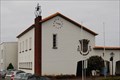
 view gallery view galleryNW3.9 km |  Santana - Madeira, Portugal Santana - Madeira, Portugal
in Town Clocks Clock mounted on the facade of Santana City Hall.
Santana is a city located in the northern part of the Madeira Islands, Portugal. posted by: manchanegra location: Arquipélago da Madeira, Portugal date approved: 11/02/2011 last visited: 01/11/2020 |
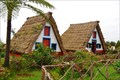 view gallery view galleryNW3.9 km |  Santana Triangular houses - Madeira, Portuga Santana Triangular houses - Madeira, Portuga
in Wikipedia Entries Situated on the north coast of Madeira about 36 km from Funchal lies the municipality of Santana, between the rugged central mountains and the northern sea. posted by: manchanegra location: Arquipélago da Madeira, Portugal date approved: 08/08/2011 last visited: 10/11/2022 |
 view gallery view galleryNW3.9 km |  Santana Triangular houses - Madeira, Portugal Santana Triangular houses - Madeira, Portugal
in Official Local Tourism Attractions Situated on the north coast of Madeira about 36 km from Funchal lies the municipality of Santana, between the rugged central mountains and the northern sea.
posted by: manchanegra location: Arquipélago da Madeira, Portugal date approved: 04/23/2009 last visited: 10/11/2022 |
 view gallery view galleryNW3.9 km |  Santana Traditional houses - Madeira, Portugal Santana Traditional houses - Madeira, Portugal
in Philatelic Photographs Situated on the north coast of Madeira about 36 km from Funchal lies the municipality of Santana, between the rugged central mountains and the northern sea. posted by: manchanegra location: Arquipélago da Madeira, Portugal date approved: 04/26/2009 last visited: 10/11/2022 |
 view gallery view gallery SW6 km SW6 km
| Peak Chiqueiros da Queimada in Mountain Summits [PT] Um pico com um nome invulgar muito pouco conhecido
[ENG] A peak with an unusual name too little known posted by: RRV1982 location: Arquipélago da Madeira, Portugal date approved: 09/20/2014 last visited: never |
 view gallery view gallery E6.1 km E6.1 km
| Ponta do Espigão Amarelo, Porto da Cruz, Madeira in Portugal Geodetic Points At Ponta do Espigão Amarelo. (Yellow Point), half way along the sea cliff trail from Porto da Cruz to Boca do Risco is a stone block. This stone, painted black and white, is an obvious waymark, a Portuguese geodetic marker. posted by: arby101ca location: Arquipélago da Madeira, Portugal date approved: 12/03/2010 last visited: never |
 view gallery view gallerySW6.3 km | A view to behold in Scenic Hikes This walk is suitable for all family members and should take less than one hour. The path is clear and flat but the views are breath taking. posted by: patanddave location: none listed yet date approved: 02/17/2006 last visited: 01/16/2020 |
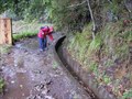
 view gallery view gallerySW6.4 km |  Lavada do Furado trailhead, Ribeiro Frio, Madeira Lavada do Furado trailhead, Ribeiro Frio, Madeira
in Hiking and walking trailheads The Levada do Furado trail starts at Ribeiro Frio on ER 103 and continues 11 km along levadas to Portela on ER 102. This is one of the classic levada hikes on Madeira. posted by: arby101ca location: Arquipélago da Madeira, Portugal date approved: 11/10/2010 last visited: 01/16/2020 |
 view gallery view gallerySW6.4 km |  Posto Aquícola do Ribeiro Frio - Santana, Madeira , Portugal Posto Aquícola do Ribeiro Frio - Santana, Madeira , Portugal
in Fish Hatcheries Aquaculture Station of Ribeiro Frio, with its nurseries of Rainbow Trout (Oncorhynchus mykissWalbaum) aim at the production of trout to replenish the water lines of Madeira. posted by: RuiJSDuarte location: Arquipélago da Madeira, Portugal date approved: 11/11/2011 last visited: 01/16/2020 |
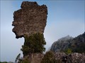 view gallery view gallery W6.9 km W6.9 km
|  Cabeça do Indío - Santana, Madeira, Portugal Cabeça do Indío - Santana, Madeira, Portugal
in Nature's Balanced Rocks Impressive rock formation with the name Indian head on the island Madeira. posted by: Windschattenwanderer location: Arquipélago da Madeira, Portugal date approved: 03/29/2019 last visited: never |
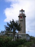 view gallery view galleryNW7.7 km |  Ponta de São Jorge Farol, Madeira Portugal Ponta de São Jorge Farol, Madeira Portugal
in Coastal Lighthouses At Ponta de São Jorge (St George Point) on the central north shore of Madeira is a fairly modern lighthouse built in 1959. posted by: arby101ca location: Arquipélago da Madeira, Portugal date approved: 11/03/2010 last visited: 07/14/2023 |
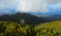
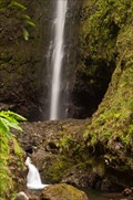 view gallery view galleryW8 km |  Caldeirão Verde Caldeirão Verde
in Waterfalls Starting at the Parque Florestal das Queimadas (Santana) and finishing at Caldeirão Verde Waterfall, has an extension of 6 Km and it is at 990 meters high. posted by: ajsa location: Arquipélago da Madeira, Portugal date approved: 09/26/2011 last visited: 08/30/2022 |
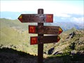 view gallery view galleryW8.7 km |  Pico Ruivo direction sign, Madeira, Portugal Pico Ruivo direction sign, Madeira, Portugal
in Direction and Distance Arrows A three direction sign in a walking trail in Madeira posted by: RuiJSDuarte location: Arquipélago da Madeira, Portugal date approved: 10/30/2011 last visited: 10/11/2022 |
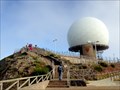 view gallery view gallerySW9 km |  Radar dome on Pico Arieiro 1818m (5965 feet) - Funchal - Madeira Radar dome on Pico Arieiro 1818m (5965 feet) - Funchal - Madeira
in Geodesic Domes Radar dome on the Pico Arieiro 1818m (5965 feet) posted by: franketmuriel location: Arquipélago da Madeira, Portugal date approved: 10/31/2017 last visited: 12/29/2021 |
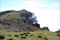 view gallery view gallerySW9 km | Pico do Arieiro, Madeira, Portugal in Mountain Summits Pico do Arieiro is the 3rd highest peak in Madeira with 1818 mts high (5965 ft). posted by: manchanegra location: Arquipélago da Madeira, Portugal date approved: 07/04/2011 last visited: 12/02/2015 |
 view gallery view gallerySW9 km | Pico do Arieiro, Madeira in Portugal Geodetic Points On the busy summit of Pico do Arieiro, Madeira is a classic Portuguese geodetic point waymark. This prominent summit is not the highest peak at 1818 m, but it gets the most visitors as it is easily accessible by road. posted by: arby101ca location: Arquipélago da Madeira, Portugal date approved: 11/04/2010 last visited: 01/23/2023 |
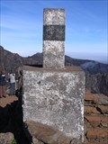
 view gallery view galleryW9 km | Pico Ruivo, Madeira in Portugal Geodetic Points Pico Ruivo is the highest peak in the volcanic island of Madeira. As you would expect, there is a triangulation mark at the summit. posted by: arby101ca location: Arquipélago da Madeira, Portugal date approved: 11/12/2010 last visited: 10/11/2022 |
 view gallery view galleryW9 km | Pico Ruivo, Madeira in Scenic Hikes Pico Ruivo at 1862 m or 6109 ft is the highest point on the volcanic island of Madeira. The hike to the summit is great scenic hike. This route is the easiest of the three approaches, the hike up from Achada do Teixeira posted by: arby101ca location: Arquipélago da Madeira, Portugal date approved: 11/17/2010 last visited: 10/11/2022 |
 view gallery view gallerySW9 km |  Pico do Arieiro - L'archipel de Madère, Portugal Pico do Arieiro - L'archipel de Madère, Portugal
in Volcano Watching [FR][FR]Le Pico do Arieiro culmine à 1818 m et forme le 3ème sommet de l'île de Madère.
[EN] The Pico do Arieiro rises to 1818 m and forms the 3rd peak of Madeira Island.
[PT]O Pico do Arieiro sobe para 1.818m e forma o 3ème cume da ilha da Madeira. posted by: Tromel location: Arquipélago da Madeira, Portugal date approved: 11/25/2019 last visited: 08/30/2022 |
 view gallery view galleryW9 km | Pico Ruivo Scenic Overlook in Scenic Overlooks The Red Peak, in Santana, Madeira Island is the third highest mountain in Portugal. posted by: RuiJSDuarte location: Arquipélago da Madeira, Portugal date approved: 12/02/2011 last visited: 10/11/2022 |
|