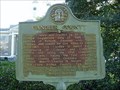
 view gallery view gallery E7.7 km E7.7 km
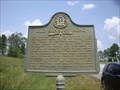
|   Candler County-GHM 021-1-Candler Co Candler County-GHM 021-1-Candler Co
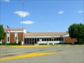
in Georgia Historical Markers Courthouse in Metter posted by:  Sprinterman Sprinterman location: Georgia date approved: 12/20/2009 last visited: 04/05/2003 |
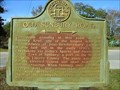
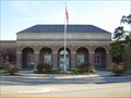
 view gallery view galleryE7.9 km |  Candler County Courthouse - Metter, Georgia Candler County Courthouse - Metter, Georgia
in U.S. National Register of Historic Places Located in the center of Metter, Georgia. posted by: Sprinterman location: Georgia date approved: 12/29/2009 last visited: 11/29/2009 |
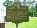
 view gallery view galleryE7.9 km |  Candler County Courthouse-Metter, Georgia Candler County Courthouse-Metter, Georgia
in Courthouses Located in downtown Metter. posted by: Sprinterman location: Georgia date approved: 12/26/2009 last visited: 11/29/2009 |
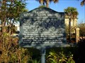
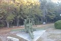 view gallery view gallery SE8.7 km SE8.7 km
|  VFW Post 5893 AA Gun - Metter Georgia VFW Post 5893 AA Gun - Metter Georgia
in Static Artillery Displays An AA Gun on display at the VFW Post in Metter, Georgia. posted by: Manville Possum location: Georgia date approved: 12/01/2010 last visited: 12/30/2019 |
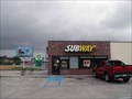 view gallery view gallerySE8.9 km |  Subway # 1257 - South Lewis Street - Metter, GA Subway # 1257 - South Lewis Street - Metter, GA
in Subway Restaurants This Subway is located on South Lewis Street (GA 23) just north of I-16 in Metter, GA. posted by: Lat34North location: Georgia date approved: 04/09/2012 last visited: 03/24/2012 |
 view gallery view gallerySE8.9 km | Old Sunbury Road-GHM 021-2-Candler Co in Georgia Historical Markers On Ga 23 2 miles south of I-20 interchange posted by: Sprinterman location: Georgia date approved: 12/20/2009 last visited: 04/05/2003 |
 view gallery view gallerySE8.9 km |  McDonald's 11011 - Lewis St. - Metter, GA McDonald's 11011 - Lewis St. - Metter, GA
in Wi-Fi Hotspots McDonald’s on S Lewis St in, Metter GA. North of I-16. posted by: Lat34North location: Georgia date approved: 03/22/2013 last visited: 03/18/2013 |
 view gallery view gallerySE8.9 km |  McDonald's 11011 - Lewis St. - Metter, GA McDonald's 11011 - Lewis St. - Metter, GA
in McDonald's Restaurants McDonald’s on S Lewis St in, Metter GA. North of I-16. posted by: Lat34North location: Georgia date approved: 03/19/2013 last visited: 03/18/2013 |
 view gallery view gallery NW19 km NW19 km
| Old Sunbury Road - GHM 053-5 - Emanuel Co., GA in Georgia Historical Markers Another marker showing the Old Sunbury Road through Georgia. Located at US 1 intersection with Ga 57 6 miles south of Swainsboro, GA. posted by:  Markerman62 Markerman62 location: Georgia date approved: 02/02/2013 last visited: 07/26/2012 |
 view gallery view gallery S20.3 km S20.3 km
| Cedar Creek Primitive Baptist Church-GHM 132-2-Tattnall Co in Georgia Historical Markers approx. 6 miles north of Collins, Ga. on Cedar Creek Church Rd. approx. 2 miles from intersection with Ga.121/Ga.57 posted by: Sprinterman location: Georgia date approved: 09/10/2010 last visited: 05/02/2010 |
  NE21.7 km NE21.7 km
|  Camp Goldhead - Portal, GA Camp Goldhead - Portal, GA
in Boy Scout Camps This camp has many trails and areas of interest. posted by: novabomb141 location: Georgia date approved: 01/21/2006 last visited: never |
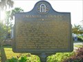
 view gallery view galleryNW26.7 km | Emanuel County Courthouse-Swainsboro, Georgia in Courthouses A modern courthouse with historic roots. posted by: Sprinterman location: Georgia date approved: 12/06/2009 last visited: 11/28/2009 |
 view gallery view galleryNW26.7 km | Home of George Leon Smith, II 1912-1973-Emanuel Co in Georgia Historical Markers on south side of public park on the old courthouse square in downtown Swainsboro posted by: Sprinterman location: Georgia date approved: 12/06/2009 last visited: 08/22/2000 |
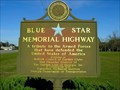
 view gallery view galleryNW26.7 km |  US 80-City Park-Swainsboro, GA US 80-City Park-Swainsboro, GA
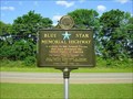
in Blue Star Memorial Highway Markers Located in the park in the center of Swainsboro, Georgia. posted by: Sprinterman location: Georgia date approved: 12/07/2009 last visited: 07/26/2012 |
 view gallery view galleryNW26.7 km | Blue Star Marker-GCG-Swainsboro-Emanuel Co in Georgia Historical Markers Located in the small park in the center of Swainsboro. posted by: Sprinterman location: Georgia date approved: 12/06/2009 last visited: 07/26/2012 |
 view gallery view galleryNW26.7 km | Emanuel County-GHM 053-1-Emanuel Co in Georgia Historical Markers Located on the former Emanuel County Courthouse square, Swainsboro, Ga. posted by: Sprinterman location: Georgia date approved: 12/06/2009 last visited: 07/26/2012 |
 view gallery view gallery N27 km N27 km
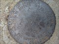
|  Little Patsiliga Little Patsiliga
in U.S. Benchmarks Standard stamped brass disk. Set in concrete on bridge. posted by: mtnboyjp location: Georgia date approved: 09/03/2011 last visited: never |
 view gallery view galleryS27.4 km |  Collins Volunteer Fire Department Collins Volunteer Fire Department
in Firehouses City of Collins Fire Department posted by: gmurphy00@gmail.com location: Georgia date approved: 02/12/2014 last visited: never |
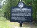 view gallery view gallerySE28.8 km | Croatan Indian Community - GHS 16-1 - Bulloch Co., GA in Georgia Historical Markers A historical marker about the Croatan Indian Community is located on Adabelle Rd at US 301 in Bulloch County, Georgia. posted by: Marine Biologist location: Georgia date approved: 08/01/2008 last visited: 12/20/2009 |
 view gallery view gallery SW29.8 km SW29.8 km
| Toombs County Courthouse-Lyons Georgia in Courthouses Located in downtown Lyons posted by: Sprinterman location: Georgia date approved: 11/27/2010 last visited: 05/02/2010 |
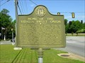
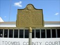 view gallery view gallerySW29.8 km | Toombs County-GHM 138-1-Toombs Co in Georgia Historical Markers Courthouse in Lyons, US 280 posted by: Sprinterman location: Georgia date approved: 11/27/2010 last visited: 07/26/2012 |
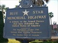
 view gallery view galleryE30.3 km | Blue Star Memorial Highway-GCG-Bulloch Co in Georgia Historical Markers Ogeechee Technical Institute, US 301, south of Statesboro posted by: Sprinterman location: Georgia date approved: 12/20/2009 last visited: 11/29/2009 |
 view gallery view galleryE30.3 km | US 301-Statesboro, Georgia in Blue Star Memorial Highway Markers In front of Ogeechee Technical Institute, US 301, south of Statesboro, Georgia
This area is landscaped very well. Even in November it looked nice. posted by: Sprinterman location: Georgia date approved: 12/20/2009 last visited: 11/29/2009 |
 view gallery view gallerySW31.7 km | Home of the Vidalia Sweet Onion-GHM 138-3-Toombs Co in Georgia Historical Markers Highway 280 3.7 mi east of Ga 29 intersection in Vidalia posted by: Sprinterman location: Georgia date approved: 11/27/2010 last visited: 05/02/2010 |
 view gallery view gallerySW32.2 km | Blue Star-Lyons-Toombs Co in Georgia Historical Markers US 1 at roadside park about 1.5 miles S of Lyons posted by: Sprinterman location: Georgia date approved: 11/27/2010 last visited: 10/24/2010 |
|