 view gallery view gallery NE45.7 km NE45.7 km
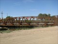
|   San Luis Small Truss Bridge - San Luis, Arizona San Luis Small Truss Bridge - San Luis, Arizona
in Truss Bridges Small farm equipment bridge over a canal..... posted by:  GIDEON-X GIDEON-X location: Arizona date approved: 07/24/2008 last visited: 07/25/2008 |
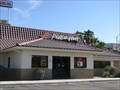 view gallery view galleryNE46 km |  Pizza Hut - San Luis, Arizona Pizza Hut - San Luis, Arizona
in Pizza Hut Restaurants Located on San Luis Plaza Drive, off Juan Sanchez Blvd. posted by: GIDEON-X location: Arizona date approved: 07/23/2008 last visited: 07/25/2008 |
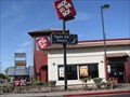
 view gallery view galleryNE46.2 km |  McDonald's San Luis - San Luis, Arizona McDonald's San Luis - San Luis, Arizona
in McDonald's Restaurants On Main Street....no crusiing here, to much traffic posted by: GIDEON-X location: Arizona date approved: 07/25/2008 last visited: 07/25/2008 |
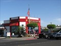
 view gallery view galleryNE46.2 km |  Jack In The Box - San Luis, Arizona Jack In The Box - San Luis, Arizona
in Jack In The Box Hot Spot On Main Street........Just A Few Blocks From The Boarder posted by: GIDEON-X location: Arizona date approved: 07/23/2008 last visited: 07/25/2008 |
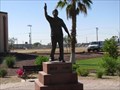 view gallery view galleryNE46.7 km |  Cesar Chavez - Founder Of The United Farm Wokers Cesar Chavez - Founder Of The United Farm Wokers
in Statues of Historic Figures The Statue looks over the hwy. coming into San Luis posted by: GIDEON-X location: Arizona date approved: 07/23/2008 last visited: 02/12/2018 |
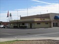
 view gallery view galleryNE47.5 km |  San Luis Police Department - San Luis, Arizona San Luis Police Department - San Luis, Arizona
in Police Stations In the new city complex on Union Street posted by: GIDEON-X location: Arizona date approved: 07/23/2008 last visited: 07/25/2008 |
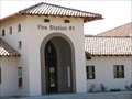 view gallery view galleryNE47.5 km |  San Luis Fire Station #1 - San Luis, Arizona San Luis Fire Station #1 - San Luis, Arizona
in Firehouses On McCain Street off Union Street.... posted by: GIDEON-X location: Arizona date approved: 07/23/2008 last visited: 07/25/2008 |
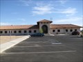
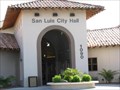 view gallery view galleryNE47.5 km |  San Luis, Arizona San Luis, Arizona
in City and Town Halls In the new city complex on Union Street posted by: GIDEON-X location: Arizona date approved: 07/24/2008 last visited: 07/25/2008 |
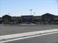 view gallery view galleryNE47.5 km |  Wal Mart Main Street (HWY 95) - San Luis, Arizona Wal Mart Main Street (HWY 95) - San Luis, Arizona
in WAL*MART Stores New Super Store In San Luis (HWY 95) posted by: GIDEON-X location: Arizona date approved: 07/24/2008 last visited: 07/25/2008 |
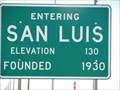 view gallery view galleryNE48.1 km |  San Luis Elevation Sign - San Luis, Arizona San Luis Elevation Sign - San Luis, Arizona
in Elevation Signs HWY. 95 South (West Side) Approx. 2 miles from the US / Mexico Boarder. posted by: GIDEON-X location: Arizona date approved: 07/23/2008 last visited: 02/12/2018 |
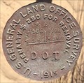 view gallery view gallery N56 km N56 km
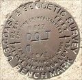
|  U.S. General Land Office Survey S. C. T16S S35 R18E S36 DOT Disk - Felicity, CA U.S. General Land Office Survey S. C. T16S S35 R18E S36 DOT Disk - Felicity, CA
in U.S. Benchmarks One of many benchmarks on old U.S. 98, just west of Yuma. posted by:  bluesnote bluesnote location: California date approved: 02/02/2016 last visited: 02/02/2016 |
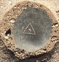
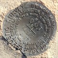 view gallery view galleryN56 km | U.S. Coast & Geodetic Survey H60 Reset Benchmark - Felicity, CA in U.S. Benchmarks One of many benchmarks on old U.S. 98, just west of Yuma. posted by: bluesnote location: California date approved: 02/02/2016 last visited: 02/02/2016 |
 view gallery view galleryN56 km | U.S. Coast & Geodetic Survey W613 Benchmark - Felicity, CA in U.S. Benchmarks One of many benchmarks on old U.S. 98, just west of Yuma. posted by: bluesnote location: California date approved: 02/02/2016 last visited: 02/02/2016 |
 view gallery view galleryN56.2 km | CalTrans End Triangulation Station Disk - Felicity, CA in U.S. Benchmarks One of many benchmarks on old U.S. 98, just west of Yuma. posted by: bluesnote location: California date approved: 02/02/2016 last visited: 02/02/2016 |
 view gallery view galleryN56.2 km | CalTrans End Reference Mark No. 1 - Felicity, CA in U.S. Benchmarks One of many benchmarks on old U.S. 98, just west of Yuma. posted by: bluesnote location: California date approved: 02/02/2016 last visited: 02/02/2016 |
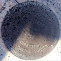 view gallery view galleryN56.2 km | National Geodetic Survey Q1362 Vertical Control Mark - Felicity, CA in U.S. Benchmarks One of many benchmarks on old U.S. 98, just west of Yuma. posted by: bluesnote location: California date approved: 05/09/2016 last visited: 05/09/2016 |
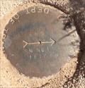
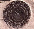 view gallery view galleryN56.8 km |  DROP DOT 1959 Azimuth Benchmark , Holtville, CA DROP DOT 1959 Azimuth Benchmark , Holtville, CA
in Azimuth Benchmarks This is the azimuth mark for triangulation station DROP, in Holtville, CA, Imperial County. posted by: Poehunters location: California date approved: 08/09/2013 last visited: 02/27/2015 |
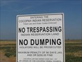 view gallery view galleryNE57 km |  Cocopah Reservation - Yuma County - Arizona Cocopah Reservation - Yuma County - Arizona
in Nations Within Nations Follow the signs out of Somerton posted by: GIDEON-X location: Arizona date approved: 08/05/2008 last visited: 02/12/2018 |
 view gallery view galleryN57.3 km | T16SR18E in U.S. Benchmarks US General Land Office Survey - 1915 - T16SR18E S29/S28,S32/S33 DOT posted by: philbeer location: California date approved: 06/06/2012 last visited: 02/25/2015 |
 view gallery view galleryNE57.5 km | Cocopah Tribal Police - Cocopah Reservation - Yuma County, Arizona in Police Stations Best to Google it for location....it's on the res. posted by: GIDEON-X location: Arizona date approved: 08/05/2008 last visited: 01/23/2009 |
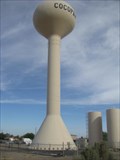 view gallery view galleryNE58.6 km |  Cocopah Water-Tower on the Cocopah Reservation - Yuma County, Arizona Cocopah Water-Tower on the Cocopah Reservation - Yuma County, Arizona
in Water Towers On the ditch bank....drive to it posted by: GIDEON-X location: Arizona date approved: 08/05/2008 last visited: 01/23/2009 |
 view gallery view galleryNE59.4 km | Somerton, Arizona in City and Town Halls On Main Street a block south of Somerton Avenue posted by: GIDEON-X location: Arizona date approved: 08/06/2008 last visited: 02/12/2018 |
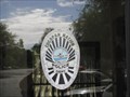
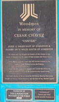 view gallery view galleryNE59.4 km |  Woodmen IMO Cesar Chavez Memorial--Somerton, Az Woodmen IMO Cesar Chavez Memorial--Somerton, Az
in Woodmen of the World Grave Markers/Monuments This plaque commemorates the birthplace, life and work of Cesar Chavez. posted by: bronco busters location: Arizona date approved: 08/25/2008 last visited: 01/23/2009 |
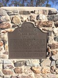 view gallery view galleryN59.5 km |  Plank Road - Felicity, CA Plank Road - Felicity, CA
in Cairns A CA state marker, just a few hundred feet north of the Mexican border. posted by: bluesnote location: California date approved: 06/02/2018 last visited: 12/24/2022 |
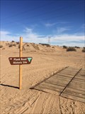 view gallery view galleryN59.5 km |  Plank Road - Felicity, CA Plank Road - Felicity, CA
in American Guide Series plank road, in the middle of the sand dunes of south eastern California. posted by: bluesnote location: California date approved: 06/29/2017 last visited: 12/24/2022 |
|