 view gallery view gallery SW8.2 km SW8.2 km
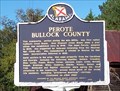
|   Perote Bullock County - Perote, AL Perote Bullock County - Perote, AL
in Alabama Historical Markers Perote, settled during the mid-1830s, was first called Fulford’s Cross Roads, then Missouri Cross Roads when a post office was established here in 1846, was renamed Perote in 1850. posted by:  hummerstation hummerstation location: Alabama date approved: 11/13/2012 last visited: 07/13/2022 |
 view gallery view gallery W8.5 km W8.5 km
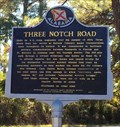
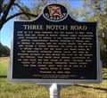
| Three Notch Road - Blues Old Stand, AL in Alabama Historical Markers Located at the corner of US Highway 29 and County Road 19 in the community of Blues Old Stand, this marker notes the building of a antebellum road thru Alabama. posted by:  hoteltwo hoteltwo location: Alabama date approved: 10/27/2015 last visited: 07/13/2022 |
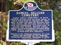 view gallery view galleryW11.1 km | Samuel Sellers Cemetery - Blues Old Stand, AL in Alabama Historical Markers Samuel Sellers (1788-1857) came to Alabama from North Carolina in 1835. posted by: hummerstation location: Alabama date approved: 11/13/2012 last visited: never |
 view gallery view gallery NW11.6 km NW11.6 km
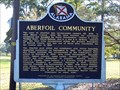
| Aberfoil Community - Aberfoil, AL in Alabama Historical Markers Aberfoil was the first town incorporated within the present boundaries of Bullock County, and was one of three sites considered for the county seat in 1867. posted by: hummerstation location: Alabama date approved: 11/11/2012 last visited: 07/13/2022 |
 view gallery view galleryNW11.6 km |  First - Town Incorporated in Bullock County - Aberfoil, AL First - Town Incorporated in Bullock County - Aberfoil, AL
in First of its Kind The town of Aberfoil was incorporated January 26, 1839, in then Macon County. When county boundaries were changed Aberfoil became the first town incorporated within the present boundaries of Bullock County. posted by: hummerstation location: Alabama date approved: 11/25/2012 last visited: never |
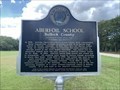 view gallery view galleryNW11.9 km | Aberfoil School - Bullock County - Aberfoil, Alabama in Alabama Historical Markers Located at on Alabama 239, 1/2 mile south of U.S. 29, Aberfoil posted by: Markerman62 location: Alabama date approved: 08/12/2022 last visited: never |
 view gallery view gallery NE14.2 km NE14.2 km
|  Merritt School - Midway, AL Merritt School - Midway, AL
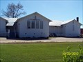
in U.S. National Register of Historic Places The Midway Colored Public School was built in 1922 with matching funds from the Julius Rosenwald Fund. posted by: hummerstation location: Alabama date approved: 12/02/2012 last visited: never |
 view gallery view galleryNE14.2 km |  Old Merritt School - Midway, AL Old Merritt School - Midway, AL
in Former Schools The Old Merritt (Midway Colored Public) School was built in 1922 with matching funds from the Julius Rosenwald Fund. It is now the Old Merritt Midway Community Center. posted by: hummerstation location: Alabama date approved: 12/30/2012 last visited: never |
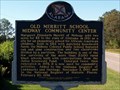 view gallery view galleryNE14.2 km | Old Merritt School Midway Community Center - Midway, AL in Alabama Historical Markers Margaret Elizabeth Merritt of Midway sold two acres for $5 to the state of Alabama in 1921 as a site for an elementary school for African-American children. posted by: hummerstation location: Alabama date approved: 11/06/2012 last visited: never |
 view gallery view galleryNE14.2 km |  Old Merritt Midway Community Center - Midway, AL Old Merritt Midway Community Center - Midway, AL
in Municipal Community Centers The Old Merritt Midway Community Center is located in the Old Merritt (Midway Colored Public) School. posted by: hummerstation location: Alabama date approved: 01/01/2013 last visited: never |
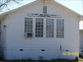
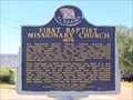 view gallery view galleryNE14.2 km | First Baptist Missionary Church 1875 - Midway, AL in Alabama Historical Markers First organized in 1875, Second Baptist was built on a one-acre site officially deeded to the church by Taylor N. Cox and wife, M. C. Cox, on April 9, 1885. posted by: hummerstation location: Alabama date approved: 11/08/2012 last visited: never |
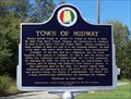 view gallery view galleryNE14.2 km | Town of Midway - Midway, AL in Alabama Historical Markers The town of Midway was incorporated on February 23, 1870. posted by: hummerstation location: Alabama date approved: 11/06/2012 last visited: 07/30/2019 |
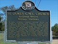 view gallery view galleryNE14.3 km | St. James C.M.E. Church - Midway, AL in Alabama Historical Markers St. James Christian Methodist Episcopal Church was founded by Reverend Jack McMillan, a former slave of Midway’s Daniel McMillan. posted by: hummerstation location: Alabama date approved: 11/06/2012 last visited: never |
 view gallery view gallery N15 km N15 km
| Three Notch Road - Three Notch, AL in Alabama Historical Markers Located at the corner of US Highway 82 and County Road 35 in the community of Three Notch, this marker notes the building of a antebellum road thru Alabama. posted by: hoteltwo location: Alabama date approved: 10/27/2015 last visited: never |
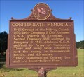 view gallery view galleryNE15.1 km | Confederate Memorial - Midway, AL in Alabama Historical Markers Older United Daughters of the Confederacy marker located at corner of U.S. Highway 82 and Main Street in Midway that describes former drill grounds. Marker appears to have just recently been installed, despite it's age. posted by: hoteltwo location: Alabama date approved: 10/27/2015 last visited: never |
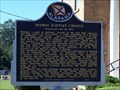 view gallery view galleryNE15.3 km | Midway Baptist Church - Midway, AL in Alabama Historical Markers Midway Baptist Church was organized in 1852 as the Baptist Church of Five Points. By April 1855, the Five points church was being referred to in its own records as the Baptist Church of Midway. posted by: hummerstation location: Alabama date approved: 11/06/2012 last visited: never |
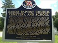 view gallery view galleryNW17.9 km | Sardis Baptist Church (1850) - Union Springs, AL in Alabama Historical Markers This marker is located in front of the inactive Sardis Baptist Church on the corner of Highway 223 and County Road 22 south of Union Springs, Alabama. posted by: hoteltwo location: Alabama date approved: 07/29/2013 last visited: never |
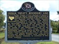 view gallery view galleryNW18.7 km | Indian Treaty Boundary Line - Union Springs, AL in Alabama Historical Markers The Treaty of Fort Jackson of August 9, 1814 established a boundary line between the Mississippi Territory and the Creek Nation. This is the marker located south of downtown on US HWY 29. posted by: hummerstation location: Alabama date approved: 11/11/2012 last visited: 07/13/2022 |
 view gallery view gallery SE20 km SE20 km
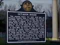
| OCTAGON HOUSE - Clayton, AL in Alabama Historical Markers OCTAGON HOUSE Historic Marker, Clayton, AL posted by: hummerstation location: Alabama date approved: 03/21/2010 last visited: 01/13/2022 |
 view gallery view gallerySE20 km |  Petty-Roberts-Beatty House - Clayton, AL Petty-Roberts-Beatty House - Clayton, AL
in Victorian Style Architecture Petty-Roberts-Beatty House (Octagon House), Clayton, AL posted by: hummerstation location: Alabama date approved: 02/14/2012 last visited: 01/13/2022 |
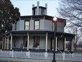 view gallery view gallerySE20 km | Petty-Roberts-Beatty House - Clayton, AL in U.S. National Register of Historic Places Petty-Roberts-Beatty House, Clayton, AL posted by: hummerstation location: Alabama date approved: 12/04/2011 last visited: 01/13/2022 |
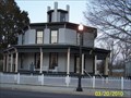 view gallery view gallerySE20 km |  OCTAGON HOUSE - Clayton, AL OCTAGON HOUSE - Clayton, AL
in Octagon Buildings OCTAGON HOUSE (Petty-Roberts-Beatty House) in Clayton, AL posted by: hummerstation location: Alabama date approved: 03/22/2010 last visited: 01/13/2022 |
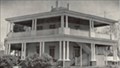 view gallery view gallerySE20 km |  Petty-Roberts-Beatty House 1920 - Clayton, AL Petty-Roberts-Beatty House 1920 - Clayton, AL
in Photos Then and Now The Petty-Roberts-Beatty House, Clayton, AL is the only surviving Antebellam octagonal house in Alabama. posted by: hummerstation location: Alabama date approved: 02/14/2012 last visited: 01/13/2022 |
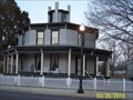 view gallery view gallerySE20 km |  Petty-Roberts-Beatty House - Clayton, AL Petty-Roberts-Beatty House - Clayton, AL
in Wikipedia Entries Petty-Roberts-Beatty House, Clayton, AL posted by: hummerstation location: Alabama date approved: 11/29/2011 last visited: 01/13/2022 |
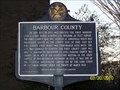 view gallery view gallerySE20 km | BARBOUR COUNTY - Clayton, AL in Alabama Historical Markers Historic Marker on the Barbour County Courthouse lawn in Clayton, AL. posted by: hummerstation location: Alabama date approved: 03/21/2010 last visited: 01/13/2022 |
|